In the summer of 2025 I hiked the Swiss Via Alpina. The trail took me from the Lichtenstein border in the East to Montreux at Lake Geneva in the West. Seventeen days of some of the best scenery in the Alps, (wild) camping most of the time!
Via Alpina (Swiss Alpine Pass Route)
Start: Sargans (480 m / 1,575 ft)
End: Montreux (396 m / 1,300 ft)Highest point: Hohtürli Pass, (2.778 m / 9,114 ft)
Distance: 358 km (222 miles)
Total Elevation Gain: 20.800 m (68,250 ft)
Total Elevation Loss: 21.700 m (71,200 ft)
Accomodation: (wild) camping, mountain huts, hotels
Time: 17 days
Hiked: August 2025

What is the Via Alpina 1?
The Swiss Via Alpine or Swiss National Route 1 is part of the greater Via Alpina that runs 2.600 km (1,600 miles) from Triest (Italy) to Monaco (France), crossing all 8 countries in the Alps. The central Swiss part covers the highest part of the Alps and some of the most iconic mountains, like Eiger and Jungfrau.
The trail was formerly known as the Swiss Alpine Pass Route. This older route differs in some of the last stages (day 15–17) from the newer route. There is hardly any difference in lenght or elevation change between the two, but the old route is somewhat more desolate. That’s why I chose the older route via the village of Gsteig. During the hike I also chose to hike alternative routes, especially in the Grindelwald region, skipping some of the more crowded parts of the trail.
At the start of the Via Alpina you must decide wether or not to include the ‘Prelude’: a stretch of trail starting in Lichtenstein, descending into the Swiss village of Sargans. I skipped the prelude and started in Sargans to avoid hiking half a day on asphalt through a business park East of Sargans.
Via Alpina Trail Overview

Overview of my itinerary on the Via Alpina / Alpine Pass Route
Accomodations on the Via Alpina 1
For this thru-hike I didn’t plan any hotel or camping, except the hotel at the end in Montreux. For this hike I decided to wild camp as much as possible, because it gives me the most freedom possible. Although booking campings, huts or hotels was not needed, this hike did require a different kind of planning. I spent lost of time studying my digital maps and trip reports by other hikers to find possible wild camp spots.
In the end, I made a bivouac (wild camp) 8 times, and stayed at an official camping 4 times. On one rainy night I took shelter in a mountain hut, the rainy days in the Grindelwald region I stayed in a hotel 2 times.
The choice of hotels was limited though. If you do not want to sleep in a tent, book your accommodation well ahead. Also note that wild camping is not strictly legal everywhere in Switzerland, but there are many, many opportunities as long as you do not camp in Nature Reserves and close too the villages.

Hotel Bären in Gsteig, on day 15 (Alpine Pass Route variant)
Getting to the trailhead (and home)
The Via Alpina is an A to B type of trail, so you will need two different airports to fly to and froom. I took an early morning flight from Amsterdam to Zürich and two subsequent trains to Sargans, so I cloud start my hike directly on Day one. At the end of the trail in Montreux I used one of the many daily trains to the airport of Geneva.
During the hike, there will be many villages with a bus- or train connection, in case you have to bail out early.
Via Alpina Books and maps
I would recommend Cicerone’s Swiss Alpine Pass Route – Via Alpina 1 by renowned Kev Reynolds. The book describes the entire route old and new. As usual I ripped out probably 1/3 of the pages to save weight and bulk.

In all my previous hikes I always carried paper maps. But this route is so long, that you would need 7 to 9 different maps to cover it all. This was too much for me and being quite familiair with Switzerland and the two languages by now, I considered it safe enough to go without paper maps and only use my GPS app on my phone. If this is your first long hike in the Alps and you don’t speak German of French it might be wise to bring paper maps as a back up for you GPS. You could buy two or three maps at the time in the villages and send them home when you’re on the next map, to save on weight and bulk.
Gear for the Via Alpina
With every hike since I started thru-hiking in 2017 I have made smaller or bigger changes to my gear list. But my 2021 gearlist from the Kesch-Bergell Trek is actually still valid. Apart from the paper maps I did not take, I only tried a shirt of a different brand and I used a new ultra light stove.
When you arrive in Switzerland by airplane in Zürich, my advice is to buy gas canisters when you transit at the Zürich Hauptbahnhof (railway station). About a 5 minutes walk South-West from the station, across the Postbrücke there is a big Transa Flagship Store that has everything a hiker could need.
Another money-saving tip. I wanted to send some fresh clothing to my hotel at the finish in Montreux. Instead of sending my package from the Netherlands, I brought it with me to Zürich and send it from within Switzerland (from the post office next to the Transa store). In this way you avoid very high international postal taxes, since Switzerland is not part of the EU.

My Zpacks Duplex, reinforced with red duct tape at the corners after 8 years of use.
At the end of the Via Alpina though, I had to say farewell to the two most important pices of gear I had: my Zpacks Duplex tent and my Zpacks ZPacks Arc Air 50L backpack. My pack started to leak seriously and on day 15, one of the carbon frame ribs was poking in my back after it got loose. The damage was beyond repair.
I have used my Duplex tent every year since 2018 and beginning in 2023 it started to show more and more wear. The upper layer was peeling off at the corners and the tent started leaking from the roof (see Part 2, Day 6).
Doing a quick calculation: 8 years of tenting, with an average 4 weeks a year, makes 225 nights in my tent. The Duplex cost me $600 (in 2018), that’s $2.66 per night. A bargain, I would say.
The Swiss Via Alpina, part 1 (day 1–3): Sargans – Rossmättli

Day 1: Sargans – Weisstannen
Start: Sargans Bahnhof (Sankt Gallen), 480 m (1,575 ft)
End: Zeltplatz Weistannen, 1006 m (3,300 ft)
Distance: 14,5 km (9 miles)
Elevation gain: 716 m (2,350 ft)
Elevation loss: 200 m (655 ft)
Highest point: Eselweg, above Mühleboden, 1.058 m (3,471 ft)Time: 3:45 hrs moving time, 4:30 hrs total time
Date: August 11, 2025
After a flight from Amsterdam to Zürich, and a train to Sargans, I arrived at 2:30 pm in suffocatingly hot village, where the tarmac felt sticky on my shoes. In the distance some mountains were visible as I hiked out of the village in half an hour.

Sign at Mels, just before ascending into the Seez Valley
Although it was a sweltering day, there was plenty of shade once I reached balcony trail above the Seez Valley. This is a high and narrow valley with steep walls. A sometimes raging river called the Seez flows through it.

Halfway up the climb, a few minutes after the highest point of the day (1.058 m (3,471 ft), I found an odd little cupboard on a pole, looking like a little birds house without an entrance. Opening a little door there appeared to be a bottle of Honey Schnapps inside! Delicious, how kind of the Swiss to leave this for the weary hiker. I wanted to leave a small donation but I had no change in my pocket.

Arriving in the village of Weisstannen, I stopped at the Hofladeli (farm shop), where you can take something from a refrigerator and then leave money in a box. I bought some yogurt, Swiss cheese, and cola. The hot sun had set early behind the mountains (thankfully) when I arrived at the primitive Zeltplatz of Weisstannen, area 10 minutes west of Weisstannen.

The Weisstannen Zeltplatz
The primitive (and free) camping (a grassy area with one pit toilet) was apparently set up to keep the many hikers out of the village. And primitive it was! There is NO WATER at this site, I was happy that I filled up all my bottles up to the max (2.5 liters) to last me until next morning.
Day 2: Weisstannen – Elm
Start: Weistannen, 1006 m (3,300 ft)
End: Zeltplatz Elm, 982 m (3,222 ft)
Distance: 22,5 km (14 miles)
Elevation gain: 1.274 m (4,180 ft)
Elevation loss: 1.292 m (4,239 ft)
Highest point: Foo-pas (2.215 m) (7,267 ft)Time: 6:35 hrs moving time, 10:25 hrs total time
Date: August 12, 2025
In the morning I had a talk with Loris, a young Swiss hiker who also followed the Via Alpina for a couple of days. We would meet every now and then during the day, each walking and resting in our own pace.
Today’s stage of the VA started with a two-hour climb ut of the Seez Valley to Walabütz, the last hamlet before the final ascent to the Foo Pass. Even early in the morning it was hot in the narrow valley. The heat made me asking myself every now and then: ‘Why was I doing this again?’
The remainder of today’s hike gave me a few good answers indeed.

Hiking along the Seez river towards the Foo Pass
I left the official trail somewhere below Walabütz, because I spotted a family campfire site just off the trail, with a picnic table and some shade. A good spot to put my tent to dry for a while, and to eat a handful of salted nuts and water.I needed some extra energy for the next four hours to the pass.
Later, after another two hours of climbing in the heat, I felt true bliss when I discovered a waterfall next to the trail, just below Alp Foo. It had a perfect 1.5-meter-deep pool carved out at the base of the waterfall, like an infinity pool. I couldn’t swim in it, but I could fully immerse myself in the cold water.

Waterfall from the Foobach, where it flows into the Seez river
Reborn from the water, I climbed another few mnutes to reach Alp Foo, an old farm where bottles of drinks were waiting in a wooden cupboard mounted on the stone wall. I had a truly refreshing Apfel Spritz.

Alp Foo’s lovely surprise
It was about 1:30 pm, so I took my time to relax for a while. Doing so in the shadow of the old farm, I observed various hikers going up or coming down from the pass.

Ascending towards Foo Pass
After another two hour’s walk to the pass, a magnificent view of the mountains greeted me. These were the real alpine mountains I had been longing for. High, rocky summits with patches of snow that would accompany me for the next two weeks.

View from the Foo Pass, with Hausstock peak (3.159m / 10.364 ft) just left of the center.
After the pass, I descended to Alp Ramin within half an hour. Alp Ramin is a far and simple shop for cheese and drinks and they served the very best drink on earth: Möhl apple cider (alcohol-free). What a wonderful way to quench my thirst.

Alp Ramin
Another half hour break before moving on. The last two hours of descending to Elm though a forest were long. However, I did see two beautiful waterfalls on the other side of the valley. One of them, the Surenfall is more than 200 meters (675 feet) tall.

View from Raminer Wald of the Surenfall and Stafelbachfall
My day ended on another Zeltplatz, this time behind Hotel Segnes in the village of Elm. Again, not a real camping, but a way of dealing with Via Alpina hikers who can’t afford €150 hotel rooms every night. Each hiker had to pay 20 Francs though, but in return there were toilets, a washing room and showers. These were actually located in a bomb shelter! All Swiss villages have such a bunker, even though the country has been free of war for 200 years.

Elm camping spots behind the hotel.
At the campsite I met with Loris again, and made a new friend: Sita, a young woman from the Netherlands. Next to my tent there was also a group of teenage boys who are audibly entertaining each other on TikTok. I fell asleep with a set of earplugs later.
Day 3: Elm – Rossmättli
Start: Zeltplatz Elm, 982 m (3,222 ft)
End: Rossmättli (Glarus), 1.381 m (4,530 ft)
Distance: 18 km (11.2 miles)
Elevation gain: 1.470 m (4,823 ft)
Elevation loss: 1.097 m (3,600 ft)
Highest point: Richlettipass, 2.260 m (7,418 ft)Time: 6:15 hrs moving time, 10:40 hrs total time
Date: August 5, 2022
This morning, my hiking companion Loris had already left, probably because a challenging hike was planned for today. Starting at 7 a.m. I was probably half an hour behind him. Leaving the campsite, I talked to a local hiker who emphasized that today would be even tougher than the day before.

View of the village of Elm in the late morning
Fortunately, this day turned out to be not bad at all. Although there was more ascent over a shorter distance, the trail was less challenging because the ascent and descent alternated. And with fewer trees to block the view, there were many beautiful sights from the trail.

Berghaus Bischofalp
Starting with a steep trail out of the village, I arrived at the Berghaus Bischofalp two hours later. An apple ciders of a different brand was also very good. Next to my table onder one of the yellow parasols was also a power outlet that I used for some extra phone charging, you never know when the next opportunity arrives.

Hengstboden
The mountains in this part of Switzerland aren’t high enough to be covered with snow, but they are still impressively steep and rocky, with green coverings of trees or grass. A collection of wooden huts at Hengstboden was picturesque. And the yellow diamond, which marks the Via Alpina route, now displayed the the coat of arms of the canton of Glarus (I had left Sankt Gallen unnoticed at the Foo Pass yesterday).

Coat of arms of Glarus on a sign at Hengstboden
A long, but not unpleasant, hike to the Richletti Pass followed. By then, Sita from Zeltplatz Elm had joined me. While I had been spending time enjoying my apple cider, she made up for her late departure by ignoring the restaurant. Unfortunately, I didn’t see Loris again; he was apparently still about an hour ahead.
Together (that is to say, I was walking about a 100 meters ahead most of the time, the trail was narrow), Sita and I walked towards the next pass: Richletti. It was a bright day, and the views were becoming more and more spectacular. The pass was visible from far away, so much better than the day before when we struggled on the steep trail through the woods.

View of the high valley below the Richletti Pass from an unnamed saddle
On an unmarked saddle before the pass I met a German woman and her dog who were resting for a while. Franceska (that was her name; the dog’s name was Thali) had already been walking for four and a half months, coming from Slovenia, Austria and Germany. And she still had two and a half month to go to hike down the GR5 to Nice.
She gave me a tip for a bivouac spot in the next valley, where she had just come from that morning. This would turn out to be a Golden Tip at the end of the day.

Cooling down at an unnamed stream
On the way to the pass, we crossed a stream: a perfect spot for a break. We took an ice-cold foot bath and enjoyed a snack. Refuelled we reached the grassy pass forty-five minutes later.

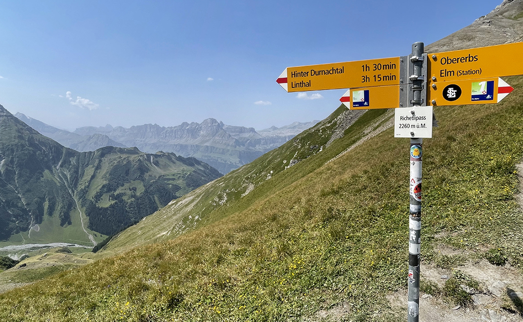
Richlettipass, 2.260 m (7,418 ft)
The descent from the Richletti Pass took about two hours. It was hot, and the winding path magically seemed to get even longer after every turn. When we finally approached the Durnagel valley, we came to a narrow path on mountain ridge called Geissruggen (Goat’s Back), according to my GPS. This was exactly how it felt, with a steep grass hill on both sides of the tral.
The reward awaited us in the form of an ice-cold waterfall at the bottom of the path, with another one of those ‘pools’ underneath (I have a knack for them). I sat under the ice cold water drenching my clothes for a good 10 minutes until Sita arrived and she took her her turn. We took another long break, coocking some noodles.

Bunker site at Rossmättli
We thought of putting up our tents right at the cool stream, but Sita noticed that this seemed to be a cattle crossing – which proved right the next morning.
Fifteen minutes further on, passing a small farm, we found Franceska’s bivouac site on a grassy area near a bunker/air raid shelter, acrss the Durnagel river. While it was close by the river, it was impossible to reach. We used the water from one of the metal drains across the road, which worked totally fine.
Exhausted from this more than 10 hour hiking day we retreated into our tents right after a simple rehydrated meal.
> Next: The Swiss Via Alpina part 2
0 Comments