Stage 4 of the GR5 was the last stage of this thru-hike that I would walk this year. It marked the transition to the Mediterranean Alps, where the weather was hotter and drier. The landscape turned more and more empty until I reached the city of Briançon where my journey ended.
GR5 Trail Overview Stage 4 (day 12–14)
For this trip report of the GR5/Grande Traversée des Alpes I use the 7 stages as defined in the Cicerone guidebook. This fourth stage of the GR5 starts in Modane, south of Vanoise National Park. I hiked this stage until the city of Briançon, roughly halfway of the entire GR5 trail. From Briançon stage 4 of the GR5 continues to Ceillac, but my time was up and I had to travel back home. Note that there are different routes between Roubion and Briançon: I followed the alternate GR5C to Lac de Cristol and then I took yet another variant that avoids the Grande Peyrolle, a high altitude and demanding crest trail.
For more general information about the GR5, read my Planning the GR5.

GR5, day 12 to 14: from Modane to Briançon (note the North is left)
Day 12: Modane to Pont de la Fonderie
Start: Modane, 1.062 m (3,484ft)
End: Pont de la Fonderie, 1.914 m (6,280 ft)
Distance: 18,2 km (11.3 miles)
Elevation gain: 1.409 m (4,623 ft)
Elevation loss: 555 m (1,820 ft)
Highest point: Col de la Vallée Etroite, 2.434 m (7,986 ft)Time: 5:40 hrs moving time, 7:20 hrs total time
Date: August 11, 2023
My Modane B&B studio was actually in Fourneaux, an adjouring village grown into the west side of Modane. So it made sense to follow the short western variant of the GR5, as I was actually already on it. A long and hot climb eventually brought me to one of the most beautiful bivouac spots of the entire GR5: Pont de la Fonderie.
Climbing out of Modane/Fourneaux
Getting back into the mountains from the low elevation of Modane/Fourneaux was not an easy task. Not only because the trail was steep and humid, but also because the Fourneaux variant trail happened to be demolished by enormous construction works above the city. They were replacing the high viaduct that snaked around the mountains and it was impossible to cross the E70 highway without a long detour further west. But I sneaked between the gates and crossed the terrain underneath the highway, climbed up, negotiated another gate and 10 minutes later I was back on track.

View above Fourneaux/Modane of the Vanoise in the north
I ascended further into the woods and after 1.5 hours since the start I reached the junction with the main GR5 trail, south of Valfréjus. This was a nice spot for a break: picnic tables, a toilet and a cool stream at my feet (Ruisseau de Charmaix). I had to get used to being alone on the trail again and I ate my early snack in silence.
Le Lavoir
Continuing uphill on a wooded trail, steeply zigzagging, I arrived at the Le Lavoir about an hour later. There was a huge fort up the hill, some hydroelectric works and a parking lot. Apparently this was the starting point for day hikes to Refuge du Thabor. Below the parking was a wonderful stream with a small shaded riverbank. An ideal spot for refreshing my body and spirit before resuming my ascent to Col de la Vallée Étroite – at 2.434 m (7,986 ft) the high point of today’s hike.

Approaching La Loza
I hiked another short but steep section until I was out of the woods completely as I reached La Loza and the dramatic mountains began to show themselves.
I encountered an elderly couple whom I helped taking a photograph of themselves (and they returned the gesture). The man told me that he once hiked the entire GR5 as a young man and now only made day hikes. I admired them for doing this at their age, but it seems to be not exceptional for the French to keep hiking in old age.

A lonesome shed at Replanette
From this part of the GR5 trail the landscape and climate was drastically changing. The general colors around me were now yellow (of the dried grass) and light grey (of the limestone rock). And all around me the crickets were chirping as a lukewarm wind blew around my head.

Pic Thabor, the pyramid top on the right, and the refuge below
Col de la Vallée Étroite
It was a long way to the col, but never steep: just a gradual ascent. Far away the Refuge du Thabor was visible, below spectaculair mountains. I considered making a 30 minute detour and visit the refuge for lunch (it was past noon after all), but I didn’t feel like it now I was alone on the trail.
With each step I could see the trail bend more to the left until I finally saw the Col de la Vallée Étroite ahead of me.
The col marks the official beginning of the Hautes Alpes, one of the least populated French departments – and it showed. Looking south from the col I saw a barren landscape, accentuated by the harsh sunlight in the middle of the day. I was surprised to find a herd of cows at this altitude.

Col de la Vallée Étroite
It had been two hours since I left Le Lavoir and my water supply was dwindling. Contrary to all the intel I gathered beforehand, there was no water at all here. The lake that I had seen on a photograph in the guidebook was dried up completely and the streams on the map were non existent. For the first time on the GR5 I experienced a slight problem with drinking water.
The descending trail was in bad shape: too many people had hiked the fragile limestone and it was really hard to get down safely. This area was Italian once, and the landscape seemed to want to confirm this by looking so similar to the Italian Dolomites. Eventually I reached a more level part of the trail at Plaine de Tavernette. The sight of multiple glinstering streams made my heart jump: ‘Water!’ I shouted inside of my head like in a silly cartoon. As soon as I reached the stream I submerged myself in it. I filtered 2 liters of drinking water, while I ate some of the cheese I still carried from Landry!

At the end of Plaine de Tavernette, just before the steep drop into La Fonderie
From now on, cool water was close by s0 my spirits were high the rest of the day. At 3 p.m., about 1.5 hours from the col, the Plaine ended quite abruptly above a steep ravine. A narrow path with some switchbacks led to a more forested area.
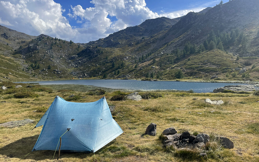
Bivouac at Pont de la Fonderie
Shortly after I saw a wooden bridge across a wild stream. Around it were a few flat, green little meadows, sheltered by pine trees. Intuitively I immediately decided: this would be my bivouac for tonight. Although I had planned to hike further to the ‘Three Magi’ village (about 30 minutes south), I had never seen such an idyllic spot before: just above the bridge, next to a small waterfall I picked a little solitary spot.

Ruisseau de la Vallé Étroite flows to the bridge at La Fonderie
It was 3:30 p.m. so I had plenty of time for cooling off in the water before setting up my tent. I spent the rest of the day reading, writing my journal, preparing one of my dehydrated meals and just looking at the endless stream of water. Another lovely end of a day in the mountains.
Day 13: Col du Palet to Lac du Cristol
Start: Pont de la Fonderie, 1.914 m (6,280 ft)
End: Lac du Cristol, 2.251 m (7,385 ft)
Distance: 19,6 km (12.2 miles)
Elevation gain: 1.181 m (3,875 ft)
Elevation loss: 857 m (2,812 ft)
Highest point: Lac du Cristol, 2.251 m (7,385 ft)Time: 6 hrs moving time, 7:30 hrs total time
Date: August 12, 2023
Day 13 was an another hot day on the trail, with two tough ascents. I followed a variant of the GR5, called the GR5C in a more direct route towards Briançon, instead of the main route via Plampinet and Montgenèvre.
The 3 Magi
Half an hour downstream from Pont de la Fonderie is a small village that mainly consists of two different huts: Rifugio Terzo Alpini (the three mountains) and Refuge I Re Magi (the Three Wise Men). Both names refer to the three distinctive mountain tops in the Stretta Valley, seen behind the village: Balthazar, Melchior, and Caspar Peak.
The morning walk to the village was pleasant and easy: the valley was still in the shade and the temperature comfortable. I skipped both huts and the Edelweiss café, as I had just had my breakfast. I rambled through the tiny village in search of a toilet building that should be somewhere according to my digital map. Eventually I found it a few minutes down the road to a parking lot, where I also saw many designated camping spots at the river.

Mont Thabor (left) and Le Grand & Petit Seru
From the village there was a steep trail in south-eastern direction heading straight up the mountain. I followed the sign to Lac Chavillon/Col de Thures to reach a higher and more level trail. Although it was still long before noon, the heat was already wearing me out. I looked forward to the big lake at the next col: Lac Chavillon.
Lac Chavillon
Lac Chavillon was a bummer. Two hours into my hike, I had been looking forward so much to take a plunge in the lake. But the entire lake was covered in brown leaves. The banks were obstructed by long green grass and the water was murky, the bottom of the lake was muddy. Of course the views were beautiful, but I couldn’t really enjoy it in the heat.

Lac Chavillon with the Three Magi
I continued on the trail, passed the actual Col de Thures a few meters south of the lake. And just like the day before I had miscalculated my water supply. Hiking in the southern part of France is really different from the northern Alps. Before me lay a vast field of dry land, a plateau of crispy yellow grass with nothing but crickets.
Chalet de Thures
Again I consulted my digital map, on which I had marked a spot at an isolated little building called Chalet de Thures. Less than an hour later, the little building turned out to actually exist, and so did the water source!

Approaching Chalet des Thures
There it was, a wooden trough with a simple black plastic hose above it on a pole. I totally drenched myself under the pouring , ice cold water. I drank and I drank and filled both of my bottles in infinite gratitude to whoever put up this source in such a desolate place. I wondered where the endless stream of water was actually coming from, there was not a stream in sight.

Demoiselle Coiffée
Soon I arrived at the end of the high plateau where a steep set of switchbacks descended into the woods. The scenery changed again. Now I was walking in a pine forest on a rocky limestone track. Typical limestone artifacts appeared, one striking rock was called Demoiselle Coiffée (the coiffed lady) but I couldn’t see the resemblance.
Lower down towards the valley I passed a wooden forestier hut with a fire place, but no water source.
Roubion
Following the crumbly tracks further downstream, the high yellow walls and debris on both sides of the river indicated that this could be a raging stream in springtime. But now the river (Torrent de Roubion) was only a trickle. I was approaching the hamlet of Roubion. I hoped to find the little grocery there open – it was almost past noon by now and my experience with French village shops is that they always close between 12 and 3 p.m.

Roubion
From the bottom of the valley the village looked like a little pioneer town in Colorado. All the houses were made of dark wood and lay scattered around a field that was dotted with dark green pine trees. I expected to see a herd of buffalo any moment.
The grocery store (Epicerie Nev’alpine) was still open – probably the large campground 50 meters further down the road provided enough clientele to keep the shop running all day. I bought yoghurt and fruit and ate my lunch on a little plastic chair in the shadow of the shop’s front. While I rested, I mentally prepared for the next step: getting out of this valley again.

Nevache as seen from above the trail to Lac du Cristol
There is a large and somewhat crowded camping (La Lame) at Roubion, at the river La Clarée. I did not consider to stay there: first of all it was way too early in the day and secondly, I had plans for something much better: a night at Lac de Cristol. So I walked downstream to Nevache, where a trail junction would lead me up the mountains.
Lac de Cristol
Nevache has an elevation of 1.580 meters and Lac de Cristol sits at 2.250. The necessary 670 m. ascent to reach the lake consisted of a steep and humid forest trail. After a while of uphill hiking I met a couple of hikers sitting on a tree, exhausted by the steep climb. They told me this was their first climb (starting in Nevache) and it was clear they had totally underestimated this trail.
But when I finally reached a more open area, after zigzagging for 1.5 hours, I discovered I had underestimated this final section as well. A wooden sign said it was still another 50 minutes to the lake.
The rest of the trail was more level but there were many ‘false cols’ that disappointed me. I also passed a few dry ponds, and I feared that Lac de Cristol would be the second bummer of the day.

Lac de Cristol
But eventually all worked out fine: there it lay in all its glory: the magnificent blue-green lake, surrounded by impressive mountain tops. And many excellent bivouac opportunities.
But before doing anything else, I stripped to my underwear and jumped into the lake. Cooling off in this one split second was so good. I swam around for a while, submerging my head and body until I was getting cold. I dried up in the afternoon sun, sitting on my folding chair and I loved my life and the GR5.

Bivouac with Thilo
After a while I heard someone call my name. It was Thilo, the last one of our ‘hiking group’ – that I actually never had met. He had joined our Whatsapp-group after he had met Christophe a week earlier and that’s how he had contacted me about bivouac opportunities at this lake. He brought a wonderful present: two ice cold cans of beer (from Rubion) that he had kept cool packed inside his backpack.
We set up our tents and drank the beer in front of our tent until it was time for one last swim, food and sleep.
Day 14: Lac du Cristol to Briançon
Start: Lac du Cristol, 2.251 m (7,385 ft)
End: Briançon, 1.215 m (3,986 ft)
Distance: 20,2 km (12.6 miles)
Elevation gain: 445 m (1,460ft)
Elevation loss: 1.480 m (4,856ft)
Highest point: Porte de Cristol, 2.483 m (8,474 ft)Time: 5:20 hrs moving time, 6:25 hrs total time
Date: August 13, 2023
Day 14: the last day on the GR5 – for the time being. After a short climb in the morning, the rest of the trail was heading all the way down to the hot and busy city of Briançon.
Porte de Cristol
Although the clouds had been menacing later in the evening, the night passed without rain or storm. My tent was soaking wet though, because of the condensation that comes with a bivouac near a lake. It was 6 o’clock and Thilo and I began packing our tents and we ate our breakfasts. My food bag was now almost empty. I had brought about 7 self made dinners and 7 breakfasts to the GR5. On day 14 all of my meals were eaten except 1 breakfast. I praised myself for planning so accurately.
At the present altitude it was too cold for a morning swim so up the first (and last) col we went.

Lac du Cristol from above
The col, Porte de Cistol, was not far away. We covered the 200 m. of ascent within half an hour. At 2.483 m we had a beautiful view back to Lac de Cristol on one side and to the mountains of Le Queyras on the other side. I looked at the Queyras with both delight and sadness: ahead lay the other half of the GR5 and I was excited to have come this far. I was sad because below those mountains I saw the outskirts of Briançon, marking the end of my hike this year.

View of the next mountain range: Le Queyras
At Porte de Cristol Thilo and I said goodbye. He was a very fast hiker and I just I couldn’t keep up with his pace (he had hiked the GR5 so far in 9 days, as opposed to the 13 days I needed). Moreover Thila planned to hike the Crête de Peyrolles, a route that I wanted to avoid because of the demanding and daunting path on a crest.
The next hour I descended to Col de Granon, a col that is famous for Tour de France history, interesting for cyclists but not for hikers. There was a good public toilet (the buvette was closed) and I continued my descent..

Crête des Peyrolles
A dark and high wall was visible to the left of the trail: La Grande Peyrolle. Obviously following that trail would have rewarded me with breathtaking views, but I didn’t have the stamina nor the guts to do it.
The alternative trail to the west of the Peyrolle was no easy stroll either. The trail was extremely steep at times and, once again, very dry. The streams visible on my map were all dry in reality. Finally, two hours after Col de Granon I arrived at a house on a junction with a gravel road with a water fountain: the Source de Serre-Lan. A typical French scene: the fountain emptied into a large stone basin in which two bottles of white wine were floating along with fresh leaves of lettuce. On the other side of the road a woman was welcoming a family while another was preparing a table for lunch in the shadow of a big fruit tree.

View of Briançon, below Croix de Toulouse
Hydrated and cooled down I followed the trail for 40 minutes until I reached Croix de Toulouse, another viewpoint above Briançon. From here the old Vauban city was clearly visible and I was eager to get there now as soon as possible.
Descending further I passed one last fountain, la Fontaine de Bon Repos, a ‘holy’ Roman source. Which made me wonder: has this source been flowing for the past 2000 years, and where does the water come from? I gulped down the holy water, soaked my shirt and I filled my bottles again. Now I arrived at lower elevation, the French the heat wave started to hit.

Briançon Vauban
About an hour later I arrived at the Briançon city limit. The GR5 runs straight through the old Vauban town. A beautiful and impressive medieval town but after more than 6 hours on my feet the sudden change in scenery was a bit too much for me. Quickly I moved on and to my delight the GR5 followed a a path through a wooded and shady park, until it reached the Dranse river. For one last time I indulged in the cold water. Then I found my B&B close by and my hike was definitely over.
GR5 (stage 1–4) Hiking Statistics
Total distance: 307 km (191 mi)
Total time: 89 hours of hiking (14 days)
Total ascent: 16.957 m (55,633 ft)Total descent: 16.011 m (52,530 ft)
Highest point: Col de la Leisse, 2.761 m (9,058 ft)Highest bivouac: Col du Palet, 2.600 m (8,530 ft)
Bivouac/ wild camp: 8 x
Camping: 2 x
Refuge: 2x
B&B: 2 x
< Previous: GR5 stage 3: Landry to Modane
> Raad also: Planning the GR5/Grande Traversée des Alpes
Thank you for posting such a helpful and detailed hiker blog for the GR5. We plan to hike the trail this summer from Chamonix to Nice. The elevation gain and loss each day is a bit sobering.
You’re welcome! The elevation gain and loss is indeed a lot every day. Once you get into the rhythm it will be easier every day. The last part to Nice is a challenge because of the lack of water sources combined with the southern heat (have not walked it myself but learned from my fellow hikers later). Have fun, it’s a beautiful trek!