The second stage of the GR5 shares about 40 km trail with the Tour du Mont Blanc. I skipped a crowded part on an alternative, higher trail above Les Contamines. After two days I left the TMB, turning South into the breathtaking Beaufortin. There I crossed the Col du Bresson, another highlight of the GR5.
GR5 Trail Overview Stage 2 (day 6–8)
For this trip report of the GR5/Grande Traversée des Alpes I use the 7 stages as defined in the Cicerone guidebook. The second stage (3 days) starts in Les Houches and ends in Landry, the gateway to the Vanoise National Park. For more general information about the GR5, read my Planning the GR5.

GR5, day 6 to 8: from Les Houches to Landry (note the North is left)
Day 6: Les Houches to Le Bon Nant
Start: Les Houches, Gîte Michel Fagot, 1.000 m (3,280 ft)
End: Le Bon Nant, TMB bivouac area, 1.512 m (4,960 ft)
Distance: 27,2 km (16.9 miles)
Elevation gain: 2.305 m (7,562 ft)
Elevation loss: 1.783 m (5,850 ft)
Highest point: Col de Tricot, 2.120 m (6,955 ft)Time: 8:25 hrs moving time, 10:30 hrs total time
Date: August 5, 2023
Day 6 of the GR5 was the second longest day in hours or distance, but it won a gold medal for the record high elevation gain of 2.305 m (7,562 ft) in one day. I followed a variant TMB/GR5-route via Col de Tricot and continued on a high route to Refuge Tré la Tête, to avoid TMB crowds in the valley. Eventually I would join the TMB hikers on beautiful bivouac spot at the Bon Nant river.
Les Houches
It was the second time for me in Les Houches, since I started and finished the Tour du Mont Blanc in this small town in 2019. I visited the Carrefour supermarket in the afternoon of day 5 to stock up on snacks for the next days (I also found a copy of Albert Camus’ novel L’Étranger to brush up on my French in the evenings).
The next morning (day 6 on the GR5) the breakfast room of Gite Michel Fagot was as crowded as the evening before, so I and my fellow solo hiker Gaëtane decided not to wait for the scrambled eggs and we set off at 7.30 a.m.
It took about 15 minutes of road walking before we turned left on a wooden stairway up the mountain, away from the village. It was dry, but cloudy. The Mont Blanc and many other peaks were hidden in a white veil. The trail was still quiet and empty. The first part of the trail to Col de Voza was familiar to me, and still steep at stages. As usual, Gaëtane was hiking much faster the way up and soon I lost sight of her.

View of Les Aiguilles from above the Les Houches ski lifts
Col de Voza
After about an hour (and 640 m. of ascend) the trail leveled out and I approached Col de Voza (1.653 m). Either I was getting higher or the clouds were getting lower – in any case visibility dropped to no more than 10 meters. The small wooden hut/restaurant at the col I visited 4 years ago had disappeared (or was I misguided by the fog?). I continued on the trail along the railroad tracks to Hotel Bellevue, where I hoped to find an opportunity for a hot drink.
I found the hotel completely deserted and surrounded by thick gray fog, which gave it an eerie appearance. I did see something much more impressive though. Two short-tailed weasels (a.k.a. ermines or stoats) came hopping towards me, stopped, put their cute nose in the air, looked at me with their tiny coal black eyes and ran off in the bushes.
Just like the weasels I left the railroad trail and entered a forest, following a steeper trail. The fog was so thick now that you might as well call it rain: I was getting soaked with tiny droplets accumulating in my hair, on my face and on my clothes.

Bridge above Torrent de Bionnassay with TMB traffic jam.
The trail began to fill with TMB groups now. Dozens and dozens of hikers emerged from nowhere so it seemed (I understood later they all had just arrived with the train that passed me close to Bellevue). Especially at the suspension bridge above the Torrent de Bionnassay there were Mount-Everest-style waiting lines to pass. And this was a less popular variant of the TMB!
Col de Tricot
The many hiking groups (Korean, Russian, Italian, American and what have you) were an incentive for me to hike faster. I challenged myself to pass as many of the groups as I could. Which was not easy because in front of every series of multi colored hiking jackets I found another string of Goretex advertising, all aiming for the top of Col de Tricot.

View towards Chalets de Miage from Col de Tricot (2.120 m / 6,955 ft)
At 11.15 I finally reached the Col de Tricot (2 hours from Col de Voza). The amazing guidebook views were absent, although as I descended towards the Chalets de Miage the the fog slowly dissolved. The descending track was extremely muddy, trampled by millions of boots. It was so slippery it occurred to me that it would be faster and safer to run down from one rock to another clump of grass. Which I did, passing many a startled TMB hiker and within 30 minutes I was down at the valley floor.
The Chalets de Miage turned out to be a professionally run drink and food facility with many guests efficiently served by countless waiters. It was here where I met Gaëtane again and we decided to hike together to the next col, below Mont Truc – another steep climb, that took us about half an hour.

Crossing a wild side stream of the Nant d’Armancette (photo Gaëtane Costes)
We passed Auberge du Truc, a refuge that seemed worth a visit for the excellent views – but not today. We still had a long trail before us to Refuge Tré la Tête. We hiked for another 45 minutes when we arrived at Les Granges de la Frasse, the junction with a trail to the village of Les Contamines. We ignored this trail and headed further up for half an hour to the Nant d’Armancette, on a tough but quiet trail. The river crossing was somewhat spectacular, using a narrow wooden beam right through the whitewater.
Refuge Tré la Tête
From this point we proceeded on a two hour long and exhausting ascend. We encountered a couple of French locals who advised us to take the high (left) trail to the refuge, that might be just a bit longer, but offered an escape from the hot and viewless forest. Another 350 m. of ascent, but with beautiful views now, followed. And then the refuge emerged from the mist, sitting on a ridge ahead.

Refuge Tré la Tête
We held a half hour break with hot chocolate and a view into the Contamines valley – and finally some sunshine. It had already been a very long day with 8,5 hours of hiking behind us, but now we had to descend to the valley again, where there should be a TMB bivouac at a small stream. Gaëtane was the first to leave while I took some extra time to fill my water bottle.

Cascade de Combe Noire
From the top of the trail there was a view of tomorrow’s Col du Bonhomme but soon I was hiking in the forest again, on a steep and rocky path. Nearby streams were flooding the path every now and then. The slippery rock demanded caution with each step. Closer to the valley I crossed a wooden bridge and passed the magnificent Cascade de Combe Noire. It looked like a lovely swimming hole, but the water was impossible to reach. And besides, I was dead tired by now and I just couldn’t wait to set up my tent and lie down.
Bon Nant Bivouac
I found Gaëtane again beside the track in a sunny meadow and together we hiked a final 10 minutes before we found the Bon Nant bivouac area.

Bivouac at Bont Nant river
The area was already quite full at the other side of the river, so we picked nice spots close to the water on the east side. The area would be filling up with more and more little tents all evening. The next morning I would count 35 tents! But for now I was happy to sit in my light weight folding chair, boots off, my body drying from a dip in the Bon Nant, my new warm puff jacket on and cooking one of my self made rehydrated meals, while sharing chunks of cheese with Gaëtane. We contacted our friends Christophe, Vincent and Max, who were all spread out in different places around the valley. We planned to meet the next day at Col de la Croix de Bonhomme, where we would also finally leave the TMB crowds behind us.
Day 7: Le Bon Nant to Plan de la Lai
Start: Le Bon Nant, TMB bivouac area, 1.512 m (4,960 ft)
End: Refuge du Plan de la Lai, 1.810 m (5,938 ft)
Distance: 18,2 km (11.3 miles)
Elevation gain: 1.208 m (3,963 ft)
Elevation loss: 905 m (2,969 ft)
Highest point: Crête des Gittes, 2.536 m (8,320 ft)Time: 5:30 hrs moving time, 9:40 hrs total time
Date: August 6, 2023
Day 7 on the GR5 was a day of mist, snow and rain. Leaving the Tour du Mont Blanc trail we hiked into the thickest fog, obscuring an otherwise excellent view. But we stuck together and found solace in our little hiking group.
Refuge de la Balme
The sound of a light but constant drizzle on my tent woke me up at 5 a.m. After six days on the trail I was not quite alarmed anymore by a few drops of rain and I turned to my other side to have some more sleep. When I woke up again, I noticed it was dry. But a look outside told me that another shower would soon be upon us, so I started packing, keeping one eye on the clouds above. Gaëtane was also awake and collecting her stuff. We decided to postpone our breakfast and get going as quick as possible before we would be soaked in another cloudburst. I stuffed al my belongings in my waterproof bag liner, closed it carefully and stuck my wet tent above it into my backpack.

Looking back into the valley, above Refuge La Balme
It was only a short hike (about 45 minutes) to Refuge La Balme, where we sought shelter under a broad plastic shelter in front of the building. How lucky we were: as soon as we arrived a serious downpour started, and we sat down at one of the dry picnic tables provided by the hut owners. While we prepared a breakfast, filled our bottles and visited the public bathrooms outside of the building, the rain subsided.
We left La Balme, abandoning our idea to pay a visit to the off-trail Lacs Jovet, one of the highlights of my TMB tour in 2019. Because of the fog there would be no chance to observe the beauty of that place. Instead, a steep 600 m. (2,000 ft) ascend lay ahead of us to Col du Bonhomme, the first of three mountain passes today. As usual Gaëtane was much faster when we were climbing, so I lost sight of her once more.
Col du Bonhomme
The snow field that I crossed below Col du Bonhomme four years ago had melted away this year. It was early in the morning, but already lots of hikers were to be seen on the trail. The tracks just below the col were seriously damaged and in some places the meadows were completely destroyed by too many off-trail hiking. The overuse of the TMB trail is nowhere as obvious as here. STAY ON THE TRAIL, folks!

View from below the pass: Col du Bonhomme (2.329m /7,641 ft)
For a moment the sun shone through the clouds, giving me hope of a good view from the pass above. But when I arrived at the col, it was even more foggy than before. Snow was falling – in fact it was blowing into my face horizontally. There was nothing to see anymore on both side of the col, what a pity.
Refuge de la Croix du Bonhomme
I continued on the trail, passing a rock slab with TMB – GR5 painted in red on the grey surface. Although this part of the trail is relatively flat and easy, with the fierce wind and the snow cover building up, I had to walk slowly and concentrate on where I put my feet. Visibility was reduced with every step.
At one point I had to cross a stream through a rocky slope which posed some difficulties in this weather. Once I scrambled up the rocks above the stream I saw the distinctive pile of rocks of the Col de la Croix du Bonhomme ahead.

Approaching Col de la Croix du Bonhomme
From this second col it was only 5 minutes to the Refuge, but by now the fog was so dense that I couldn’t even see the hut until it was just 50 meters ahead of me. I walked around the building to the back where I found the entrance. Below the deck were two donkeys seeking shelter as well. I took off my snowy shoes outside of the hut and stepped into blue plastic clogs provided by the hut. And there was Gaëtane again welcomimg me at the door. Soon Vincent, Maelys and Christophe all arrived at the hut as well. While the hut was getting more and more crowded, we wondered if our friend Max might arrive. We always lost him ont the trail, but he would also appear out of nowhere every time. But not today.

Leaving Refuge de la Croix du Bonhomme
It was getting so crowded in the refuge now (the warden kept calling: no shoes, no hiking poles inside the refuge!), we decided it was time to leave and get ourselves on top of the Crête de Gittes: a narrow ridge with steep drops on either side. On sunny days this should be one of the highlights of the GR5. On this snowy day we were mostly worried not to slide down the steep sides.
Crête de Gittes
The crête was shrouded in thick fog so instead of inspiring views ahead all we saw were the steep drops on our sides. A fierce snowstorm was blowing so we all walked in silence, considering every step with great care. Although this part of the trail was not what we hoped for, hiking along the ridge together was exiting en memorable.

Crête des Gittes
The weather was getting worse and at one point hail stones were blowing in my eyes and I had problems moving on. But soon the path was descending with a few hairpin curves and suddenly we had arrived at Col de la Sauce, which happened to be one of those cols again that was at lower elevation than were the trail started.
Plan de la Lai
From Col de la Sauce we descended further on a broad gravel track, called piste blanc in French, as I learned from my hiking companions. That was one of the nice things about this hike: I was picking up on the French language that I learned at school so many years ago. After a week I was beginning to understand most of what they said in their native tongue (speaking it myself is a whole different thing).
For a short while the clouds were blown away a little and below the tiny settlement of Plan de la Lai came into view.

View towards Plan de la Lai
There are three refuges in the village of Plan de la Lai: first we passed Chalets du Plan de la Lai, then Refuge du Plan de la Lai and finally Refuge Plan Mya. Only the last two offered limited space for tents. All of the huts were booked full when we arrived, and unfortunately, so were the bivouac spots. After we tried unsuccessfully at Plan Mya, we walked back to Refuge du Plan de la Lai where we were allowed – thanks to negotiations by my French friends – to bivouac in a large orange dome tent that they had just set up the day before. There was just enough room to set up our 4 tents inside the dome tent.

Explaning another hiker how we managed to set up four tents inside one big one at Plan de la Lai.
We decided to use our tents instead of putting our sleeping pads on the ground, because the floor was muddy and overgrown with plants. We also needed some extra warmth, as a heavy rain storm had begun so fiercely that the wind was blowing inside the dome tent as well.
The people at the refuge were extremely nice. They let us camp and use the bathroom for free and they served us an excellent dinner (only €20). We stayed in the warmly heated hut the whole evening, trying to dry socks, insoles and underwear around a red-hot wood stove, together with another 25 guests. At one point the area around the stove was completely surrounded by a mountain of boots and clothes.
We met two new hikers: Flore from Marseille and Emily from Paris, soon to be included in our group when we met them again the next day in Landry.
Day 8: Plan de la Lai to Landry
Start: Refuge du Plan de la Lai, 1.810 m (5,938 ft)
End: Landry, camping Canopée 790 m (2,592 ft)
Distance: 28 km (17.4 miles)
Elevation gain: 1.052 m (3,451 ft)
Elevation loss: 2.089 m (6,843 ft)
Highest point: Col du Bresson, 2.465 m (8,087 ft)Time: 8 hrs moving time, 9:50 hrs total time
Date: August 7, 2023
Day 8 on the GR5 turned out to be the longest day in distance (28 km) and also the most extreme in descent (more than 2.000 m). We crossed the beautiful Beaufortin, climbed one of the most impressive cols before a long descent to Landry, the end of stage 2 of the GR5.
Leaving Plan de la Lai
The night had been tempestuous and when I woke up to the sound of rain and wind raging, I was thankful for being safe inside my little tent inside the big dome tent at Refuge Plan de la Lai. But in the morning I discovered the downside of our setup: the heavy condensation on my tent was practically pouring down my face. The four of us were busy quite some time trying to get the moist off our tent fabric. When finally everyone had packed and eaten breakfast, it was already 8 a.m., which was quite late for the long trail ahead of us.
Gaëtane and I were ready to leave but we waited a while for the others. Meanwhile she was teaching me some more French and I learned the difference between J’entend and J’attend (I hear vs. I wait). Standing on a rock a bit higher than me (to catch the first sunlight in her face) she demonstratively said J’attend, not without a mild annoyance about the slow pace of the rest of the group.

Refuge du Plan de la Lai in the morning
Le Beaufortin
Leaving the village, we climbed the hills above the artificial lake Roseland. First we crossed Petit Berge, where a stone hut and the flat area around it provides an excellent bivouac spot. Later we passed by Grande Berge (you guessed: this was a bigger hill). Christophe was the only one to take the side trail towards to top for a good view of the lake below.
The sky was perfectly blue and we all were in good spirits. Our eyes focussed on the mighty mountains ahead of us: Pierre Menta and Pointe de Presset. But when we looked behind us, we were knocked off our shoes by an even more monumental sight: Mont Blanc.

Mont Blanc as seen from the Beaufortin
So now we finally saw the famous mountain that we had been so close to for two days without even catching a glimpse of it. We had what we called our ‘Brevent’-moment: a view of Mont Blanc that we completely missed two days prior when we had to skip the Brevent mountain top above Chamonix.
We crossed more green meadows, muddy and slippery from the rain, while the view in front of us became more and more impressive. The snow that fell yesterday still covered the mountains above the 2.000 meter contour line as if it has been dusted with icing sugar.

View of Pierre Menta (photo: Christophe Bellot)
But we would have to hike two more hours before we reached the foot of the mountains. First we descended a while, then followed a steep section with slippery rocks where the flowing stream and the trail were sometimes indistinguishable. I slipped and for the first time in many years I actually fell – hitting my shins on the sharp rocks. I injured one of my hands and almost lost one water bottle that was catapulted out of a side pocket of my pack. But while my hiking family looked worried at me, after a deep breath I could conform that all was well.
Col du Bresson
Shortly before we reached the snowy ascent of Col du Bresson, out of nowhere our friend Max came walking up to us from another trail, as if guided by a invisible force to make our hiking group complete again.

Col du Bresson ascend
We started our ascend together but soon we all dispersed along the track, depending on our personal hiking speed. Christophe lead up front of course, followed by Gaëtane and Max, leaving Vincent and me in the rear. The trail was steep and slippery with snow and soon I was hiking absorbed in my own thoughts, concentrating not to fall again.

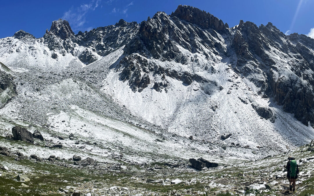
Our reunion on top of the Col du Bresson (2.465 m / 8,087 ft)
The final push to the col was rewarded with one of the best views on the GR5 so far (see photo on top of this page). We reunited again, admiring the views ahead of the Vanoise mountains, the next stage of the GR5. We had hiked for 4 hours since we left Plan de la Lai (it was exactly noon when I reached the col), halfway through our hiking day.
Refuge La Balme
On such a long day, it’s always important to set a next goal nearby. For now this was Refuge La Balme, about 1.5 hours down in the valley (this refuge being the third La Balme refuge I have ever visited. Still my French friends could not tell me what a balme actually is).

Stream below Col du Bresson
I was hiking down fast through rocks and muddy grass until I reached a lovely stream. It was time for a refreshing bath in the ice cold water! I catched up with Gaëtane and Vincent again and before we knew we already reached the refuge. The weather was splendid and the hut offered all kinds of irresistible food: I ate two pieces of lemon pie and a big omelette, gulping down a can of Coke Zero and lots of water from the hut’s fountain.

View down the valley from Refuge de la Balme
Meanwhile we unpacked our tents to dry in the warm meadow, along with socks and other wet clothing. We stayed at the refuge for more than an hour until our stuff was dry and our bellies were full – ready for the final descend to Landry at 2.30 p.m.
Vazelan
The descend through the valley was beautiful, following the river l’Ormente together with Christophe. Now I was hiking down I could easily keep up with his speed. The trail diverted from the stream after an hour, going up a hill from which there was an excellent view of the Vanoise and the valley of the Isère below.

View above Vazelan of the Vanoise
Next stop: Vazelan. This took us little less than an hour. It was awkward to be back in civilization: paved roads, cars, traffic signs, people in normal clothing. And a lot of water fountains! I used every single one to to immerse myself in the ice cold water.
From Vazelan, we reckoned we’d reach the town of Landry pretty soon, but little did we know that we had a quite challenging hike of 1.5 hours ahead of us.
Landry, Camping Canopée
When you hike high in the mountains, you get used to the cool air at higher elevation so much that you can forget about the normal summer heat in this part of France. We had descended as low as 735 m (coming from the col at 2.465 m) when we reached Bellentre at the bottom of the Isère valley and it was HOT.
And it was in this heat that we had to cover the last 40 minutes on melting asphalt, but we made it all the way to Landry after a total of 8 hours of walking. I found a good spot at Camping Canopé, a camping that I highly recommend for GR5-hikers. The staff is extremely friendly and although the camping was fully booked, they still offered me a nice spot, and even when Gaëtane and Max arrived later, two more tents were squeezed in.

My spot at Camping Canopé behind the owners trailer
Moreover, the campsite has good showers, a food truck, a cluster of sockets to charge phones and an electric water cooker. There is also a small grocery store around the corner, so I stocked up on cookies, chocolate and a huge chunk of Beaufortin cheese.
The evening was spent together on the deck next to the food truck, where we had delicious meals and drinks. The comradely get-together with all the rest of our hiking group – totaling 7 now– had a sad side though. We had to part with Gaëtane, who would be taking a train back to Paris the next morning. The sun had already set when we all gave her our final goodbyes and hugs as if losing a life long friend. Time, distance and people: it’s all different on the trail.
< Previous: GR5 stage 1: Lac Léman to Les Houches
> Next: Gr5 stage 3: Landry to Modane
cool! will do it this summer : ))
Nice!