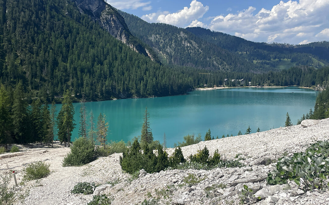
Lago di Braies (also known as Pragser Wildsee in German) is the famous starting point for the Alta Via 1 thru hike across the Italian Dolomites. But there are also various shorter trails starting at the azure blue lake. Here are three day hikes that I hiked at Lago di Braies.
Day Hikes from Lago di Braies
Below I have listed three day hikes in the Lago di Braies area, rated from easy to difficult:
- Grande Apostolo: 2 hrs out and back, 450 m (1,476 ft) elevation gain/loss. Easy
- Hochalm: 6 hrs round trip, 1.570 m (5,150 ft) elevation gain/loss. Moderate
- Sella dei Camosci (Gamssattel): 5 hrs roundtrip, 1.075 m (3.527 ft) elevation gain/loss. Difficult

Although the second hike (Hochalm) is longer and has more elevation gain than the third (Sella dei Camosci), I would rate only the last one as difficult, because of the exposed ascent on a scree slope towards the saddle.
The first hike – to the Grande Apostolo – coincides with the beginning of the third hike, as you can see on the map above. Note: another very short hike in the area (the one around the lake) is described in a previous post: the Prologue to the Alta Via 1.
The various trails, mountain tops and saddles around Lago di Braies are know by both German and Italian names, as these are the languages spoken in this part of Italy. Most of the trail signs will display both the Italian and German names. But it can still be confusing, because sometimes different synonyms in the same language are used. For example the German sattel = scharte (saddle, pass) and alm = alp (high meadow); or the Italian Ütia = Malga = Rifugio (mountain hut).
In the text below, as well as in the maps will use the most common, which can be in either language.
Day Hike 1: Grande Apostolo
Start/End: Lago di Braies (Pragser Wildsee) 1.496 m (4,908 ft)
Route number: 58
Distance: 6,6 km (4.1 miles) round trip
Elevation gain/loss: 450 m (1,476 ft)
Highest point: Grande Apostolo (Großer Apostel), 1.995 m (6,545 ft)
Time: 2 hrs
Rating: EasyHiked: July 10, 2023

Overview of Day Hike 1: Grande Apostolo
Waking up in Hotel Lago di Braies is a memorable experience. When I opened the curtains of our room on a sunny july morning, I saw the azure blue water with the Grande Apostolo towering above. This mountain top at almost 2000 meter elevation was my goal for today. After enjoying a delicious Italian breakfast, I took off for trail nr. 58, which starts at the northern shore of the lake.

Lago di Braies and the Seekofel as seen from the north side of the lake.
The trail was already a bit busy at this hour (9 a.m.) but within a few minutes I found the trail junction to the left on the other side of the lake. From that point I had the trail all to myself.

Ascent to the Grande Apostolo, view of Herrstein mountain top
After a few curves through a wooded area, I arrived on a typical Dolomiti trail of dusty, white chalk. The path wound through a scree slope that seemed to be a dry river bed. The mountain top called Herrstein/Sasso del Signore (The Lord’s Rock) was towering above me. The sun was still hidden behind the mountains.

View of Monte Nero (center) and Hochalpenkopf (far right)
After a steep stretch the trail opened up to wonderful views to the west and north. In the west Monte Nero (Black Mountain, although it is more green than black) was visible. Lago di Braies sits directly at the foot of this mountain. Beyond Monte Nero lay the high alpine meadows (Hochalp) and the tilted crust of rock Hochalpenkopf. I tried to get a good look at the area, for this was where the trails would lead me the next day would (see Day Hike 2).

View north into Austria
To the north – looking behind me –the high mountain tops all the way into Austria were visible. And although these views were all amazing, I was especially anticipating the moment that I would finally corner the mountain and Lago di Braies would come into view.
Viewpoint from Grande Apostolo
Eventually I arrived at a saddle where the views were hidden behind trees again. The 58 trail turned left, but on my right hand was a path uphill: an unsigned path to the Grande Apostolo top. Full of expectations I turned right and soon I was rewarded with a dramatic view of the lake below and all the mountains ahead.

View from the top of Grande Apostolo: Grünwaldtal, Monte Nero, Hochalpkopf and Lago di Braies (+ hotel)
At the top of Grande Apostolo I found a pleasantly positioned wooden bench. It was quite nice to sit down there after more than an hour of climbing. I enjoyed the view and I tried to catch the attention of my wife who was sitting at the sunny balcony of in the hotel below. But to her I was completely invisible, high up the mountain.
From the top op Grande Apostolo it’s an easy hike down, back to the lake. But I decided to continue – on a more strenuous hike – to the Sella dei Camosci / Gamssattel (see Day Hike 3 below).
Day Hike 2: Hochalm
Start/End: Lago di Braies (Pragser Wildsee) 1.496 m (4,908 ft)
Route numbers: 19 – 6- 61a – 61
Distance: 18,3 km (11.4 miles) round trip
Elevation gain/loss:1.570 m (5,150 ft)
Highest point: Hochalp, 2.368 m (7,769 ft)
Time: 6:15 hrs hiking time, 7:30 total time
Rating: ModerateHiked: July 11, 2023

Overview of Day Hike 2: Hochalm
This day hike is more challenging than the hike described above, especially because it is a very long day hike: more than six hours of walking. So this day I got up as early as possible and I enjoyed another excellent breakfast with all the other hiking guests already in their hiking clothes.

The early 20th-century Lago di Braies Chapel
I followed the first part of the Alta Via 1 along the western shore of Lago di Braies, passing the famous chapel, to the junction with the Grünwaldtal. There I left the AV1 and headed west into a valley with green woods, as you might have guessed from the name.
Grünwaldtal
The path followed the banks of a broad, but completely dry, river bed (Ru Fosch). There were many beautiful picnic spots between the trees. After 40 minutes I arrived at the Grünwald Alm, a restaurant where the staff was busy laying the tables for future guests. I passed a cool water fountain and then followed the trail along the dry Ru Fosch. I took me about an hour before I eventually reached a point where there was water flowing in the river, close to a solitary mountain hut in a green meadow.

View of the Grunwaldtal and Ru Fosch
The trail split in two at this point, and I followed the sign to the right, up into the mountains. From this point the trail was steep – and hot. After 45 minutes there was a very welcome ice cold waterfall in the river beside the trail, a lovely opportunity to get my shirt and hat soaked. This was the boost I needed for the final ascend to a green plateau, where I found a few wooded houses scattered in the field. Around the corner of these sheds sat the Ütia Fojedöra: a group of farming buildings and a mountain hut/restaurant.

Ütia Fojedöra farm and mountain hut
Ütia Fojedöra
The farm lay in a deep green bowl between high rock walls. It was 10:30 a.m., too early for lunch, but the hut was irresistible: before the hut a young woman was baking bread in an outside wood fire oven. About two dozen of freshly baked loaves lay outside on large trays, spreading their wonderful scent. Around the hut grazed cowes, donkeys and some goats. Pigs and chickens roamed freely. It was one of these typical family run huts where you see a mother and a few daughters peeling a massive amount of apples when you step inside to place an order for a drink.

Ütia Fojedöra as seen from the higher part of trail nr. 19
I drank a huge glass of Johannisbeersaft (red currant juice) – they don’t do Coca Cola here – before I continued on my hike. I followed the last part of the route nr. 19 and turned right on the 6 the reach the Hochalm (high meadow). Once at high elevation, the trail went up and down towards the Flatschkofelscharte from where I continued on route nr. 61a.

View from Hochalp route 61a.
The trail 61a crosses the high plateau of the Hochalp (or Hochalm) on a narrow balcony trail with amazing views into the Italian Dolomites. To reach the high trail, you must cross a steep section of scree slope below the tops of the Mauerkopf and the Hochalpkopf. This was certainly the most challenging part of the hike.

Pragser Furkel with a view of Croda Rossa on the far right
Pragser Furkel
Later I passed a junction with a side trail to the summit of the Hochalpkopf, but I decided to let that opportunity pass – this hike was already long enough. In the distance the Pragser Furkel came into view: the ridge of the tilted mountain that I was walking on. Along the ridge a long rock fence had been built, probably to keep goats from falling into the abyss beyond.

View from below the Pragser Furkel, with the Herrstein above Lago di Braies
The trail descending from the Hochalp was zigzagging extremely steep through low bushes and rocks. I was hiking very slow and it took me about an hour to reach the Kaser Alm, a former cheese farm that recently renovated into a restaurant and bar. Although the lounge music they played annoyed me terribly, I was so tired and thirsty that I spent some time with a drink on their deck, that offered a splendid view to the Grande Apostolo.

Hotel Lago di Braies as seen from the west side
The last 45 minutes of trail consisted of partly entirely new tracks that were not even on the map yet. But it was easy to find my way back to my hotel. It was 15.30 p.m. when I arrived ‘home’ again to join my wife Christine, who had just finished her remote work on her laptop. Time for a jump into the cold lake! And after the swim an Aperol Spritz, today’s fashion drink, which I would highly recommend after a long and hot hike.
Day Hike 3: Sella dei Camosci / Gamssattel
Start/End: Lago di Braies (Pragser Wildsee) 1.496 m (4,908 ft)
Route numbers: 58 – 28 – 4 – 1 (Alta Via 1)
Distance: 14,2 km (miles) round trip
Elevation gain/loss: 1.075 m (3.527 ft)
Highest point: Sella dei Camosci (Gamssattel), 2.434 m (7,986 ft)
Time: 5 hrs moving time, 6:40 hrs total time
Rating: Difficult
Hiked: July 10, 2023

Overview of Day Hike 3: Sella dei Camosci / Gamssattel
I actually improvised this hike as an extension of Day Hike 1 to the Grande Apostolo (see above). When I arrived at the mountain top of Grande Apostolo, I felt it was way too early to return to the hotel (it was only 10 a.m.). So I consulted my map and GPS to see if there was another route. If I’d continue to the Gamssattel I would eventually connect with the Alta Via 1 (a well know trail to me) from where I could hike in opposite direction back to the lake.

Lago di Braies seen from the East
So I set off towards the Weisslahnsattel, a saddle below the Herrstein mountain. I followed a balcony trail (still on route 58) with a whole new view of the lake, which seemed to be heart shaped from this angle.

An exposed section of route 58
The trail was contouring the mountains with little elevation change, but there was one rather exposed section. The path had been destroyed by rockfall and firm wooden beams made it possible to cross the steep scree slope.

Route 58 towards the Weisslahnscharte
Weisslahnsattel
Later, the trail led me through dense shrubs and trees for a while, but soon I reached a barren gravel area. A familiar scene of grey-white Dolomite gravel. Rocks were towering above me while I tried to catch a glimpse of the saddle in the distance.

Weisslahnsattel, end of route 58
Arriving at the saddle, it was 11 a.m. – two hours into my hike. From this point there was also the possibility to ascend the adjacent mountain top Herrstein (2.447 m / 8,028 ft). But the route to the double summit of Herrstein is a more of a mountaineering route, not a hiking route. So I hiked further on route 28, but not without hesitation. The trail ahead was a thin line cutting through a steep scree slope. These kind of slopes can be treacherous. So I decided that I would only continue on this trail as long as the path was three boots wide at minimum.

Herrstein as seen from the trail to Sella dei Camosci (Gamssattel)
Sella dei Camosi
The path cut trough the grey-white slope was surprisingly good: level and three boots wide all the time. There was only one instance that rockfall had destroyed the trail: I had to scramble very carefully some rocks and gravel to get to the trail again. But is was not really dangerous, because the slope was not very steep yet.

Approaching Sella dei Camosci (Gamssattel)
I counted about 35 switchbacks before I got sight of the actual pass. One tiny yellow flower had managed to grow in this barren landscape, just below the pass.
When I finally made it to the pass, the view to the southern side was quite different from what I left behind me. Instead of the white and empty rock fields, the were green meadows ahead, with what seemed like a good and trustworthy path across.

Sella dei Camosci (Gamssattel)
Directly to the left of the pass was the trail to the summit of the Grosser Rosskopf (Sasso Rosso), to the right a narrow path to it’s sibling the Kleiner Rosskopf. I had no intention of hiking (or climbing) up to either of them, I was eager to move to a safer trail.

Croda Rossa seen from the trail 28
I continued on the trail 28, a typical Dolomite trail through green meadows, with white stones scattered all around and the occasional herd of cows. In the distance the Croda Rossa was visible, with the distinctive red slopes.

Seekofel as seen from the east, with AV1-route Forno below
Alta Via 1
Eventually I reached a junction of various trails, where I followed trail nr. 4 back to Lago di Braies. To the west I saw Seekofel and the Alta Via 1 section called Forno (the Furnace), a notoriously hot trail that leads to the Biella Hut. I descended a pleasant the trail towards a little lake (Lago del Giovo/Seabl) that I had noticed the year before when I hiked the Alta Via 1. From a distance the lake did not look attractive: with the yellow-brown color it seemed to be a muddy pool.

Lago del Giovo (Seabl)
When I reached the lake however, I discovered the lake had very clear and clean water. It was mainly the ubiquitous vegetation that colored the lake. I stopped for a break – I had been hiking for about 5 hours now and I cooled my feet in the lake while I ate my last bits of the hotel’s breakfast that I had taken with me. Such a nice spot, and I had the place all to myself – as a matter of fact I had not met a soul during the entire hike so far.

Following the Alta Via 1 back to Lago di Braies
Lago di Braies
About 15 minutes later I connected with the Alta Via 1, which was a completely different experience descending, compared to the steep ascent when I hiked it in opposite direction last year. I took me more than an hour to reach the lake again. I was slowed down because my knee began to hurt seriously from the steep descent. When I eventually reached the lake I was rather overheated and as soon as I reached the shore, I took of my clothes and jumped right in. The water seemed to hiss as I immersed my glowing body in it. Within 1 minute I was completely revived, and I hiked around the lake, back ‘home’, in another 20 minutes.
Splendid pictures and great advice. Thank you so much.
Thank you!