The Hermit Trail is a mostly unmaintained (but well defined) trail into the Grand Canyon. It’s a historic trail, the first constructed for tourists in the Grand Canyon. I made a two-day hike with my 4 children to Hermit Creek and back, in the springtime of 2025.
I chose the Hermit Trail for several reasons. Firstly, I had not hiked this trail before (after Havasupai, Bright Angel and the Escalante Route it would be my 4th time in the Canyon). Furthermore, the Hermit Trail has less traffic than the corridor trails, like Bright Angel, which makes Hermit a peaceful and quiet hiking experience. Finally, in the 2024-25 season the main trails from Grand Canyon Village were all (partly) closed due to the Transcanyon Waterline project. This left me not much choice but this trail.
Grand Canyon Backcountry Permit
All overnight hikers in the Canyon must get a backcountry permit through Recreation.gov. In previous years Grand Canyon used a rather inefficient permit procedure (using fax machines!), but now it’s all online and easy. But obtaining a permit is still a lottery. I registered for this lottery about 4½ months in advance. (see Grand Canyon National Park Service for details). With two adult children, we entered the lottery simultaneously three times for better chances. We managed to get exactly the permit we wanted.
Camping in the Grand Canyon
There are two designated campsites within the Hermit Creek drainage. These are the Hermit Creek (with pit toilet) and Hermit Rapids, right at the Colorado River. When you get acces to the lottery, you specify which camp you want to stay at. We opted for Hermit Creek. The creek is still 1.5 miles (2,4 km) away from Hermit Rapids at the Colorado River. It takes an hour to hike from the creek to the river. Do not underestimate this last ‘oh it’s just another hour’-hike. After a 4000 ft (1.200 m) descend into the Grand Canyon, nothing is easy anymore.

Overview of the Hermit Trail to Hermit Creek, Grand Canyon National Park
Getting to the Trailhead
The Hermit Road to Hermits Rest is closed to all private traffic from March to December. There is a free shuttle bus (Red Line) to Hermits Rest about every 10 minutes from Grand Canyon Village. But permit holders are allowed to drive the road: a 4 digit code which is printed on the permit gives acces at the gate. At the end of Hermit Road (8 miles west) you’ll find a large bus parking at Hermits Rest. Continue on the dirt road ¼ mile to the hikers parking at trailhead.
Water sources
There is a good water faucet at the trailhead (close to the toilet building). There is only one tiny water source between the trailhead and the campsite at Hermit Creek, at Santa Maria Spring, 2.5 miles in. So we stocked up on water, about 2 liters each before heading down. Looking back, I’d recommend to bring about 3 liters per person.
At the Hermit Creek campsite, the creek is a permanent water source that flows all the way to the Colorado River. Of course, if you would hike further, the Colorado is another water source. Note that all water must be filtered.
Gear in the Grand Canyon
As a father I know the physical limits of my youngest, so I carried most of the gear for her. She only had to carry a small daypack with sleeping bag & pad, a few clothes and a bottle of water. Her brother carried their 2-person tent, while I had all the food for 5 persons/2 days, which alone weighed about 13 lbs (6 kg).

The essential gear for a Grand Canyon hike in one picture: dried food, food protection, waste bag, stove, boots… and water, water, water, water.
For the rest of the gear, take a look at my Escalante Route Gearlist. You’ll find all info on protecting your food (I carried a bear canister) and other bare necessities in the Canyon.
With Kids… Really?
Although the National Park Service explicitly notes For experienced desert hikers only on their website, I hiked the Hermit Trail with my four children, none of whom were experienced desert hikers. But they all had done serious hiking in the French and Swiss Alps, and I have spent more than a few days in the Grand Canyon myself. This experience gave me confidence that our group of five would be safe on the trail.

My family / fellow hikers aged 16, 25, 27 and 12, ready for further descend on the Hermit Trail
I believe the Hermit Trail is doable for kids from about 12 years and up, provided that they have hiking experience and particularly a lot of stamina.
Safety on the Hermit Trail with Kids
Hermit Trail is no comparison to the Bright Angel Trail: it is really rough, and sometimes not a trail at all. It makes sense to wear sturdy hiking boots and to use trekking poles for stability. Make sure to know how to use them and practice beforehand.
Take note that the mostly level section between Santa Maria Spring and the Cathedral Stairs might give a false feeling of safety. Although basically flat, the trail has some exposed parts, where great care is needed. As a leader of your group, make sure everyone stays 100% focussed. This means:
- only take photo’s during rest stops – never while walking
- never run
- don’t listen to music through earpods etc.
- stay on the trail
- stay within sight of each other
Apart from these warnings, keep in mind that the National Parks Service tends to exaggerate the dangers of most Canyon hikes in order to scare off inexperienced (or sometimes plain ignorant) tourists.
Sections of the Hermit Trail
To make this trip psychologically more feasible for children (but actually for adults as well) we divided the trail into 5 imaginary sections. Every time we completed a section we were motivated to continue on the next, despite fatigue. The sections were: 1. Coconino Stairs; 2. Stairs to Santa Maria Spring, 3. Santa Maria to Lookout Point; 4. Lookout Point to Cathedral Stairs; 5. Tonto Trail.
Day 1: Descent to Hermit Creek Campsite
Start: Hermit Trailhead 2.024 m (6,640 ft)
End: Hermit Creek Campsite 900 m (2,953 ft)
Distance: 12,1 km (7.5 miles)
Elevation loss: 1.196 m (3,924 ft)
Elevation gain: 68 m (223 ft)Hiking time: 4:52 h (7:00 total time)
Rating: Moderate- strenuousHiked: April 27, 2025

The ‘OPTIONAL / MANDATORY’ sign at the trailhead, 2.024 m (6,640 ft)
Section 1: the Coconino Stairs
We parked our car right at the trailhead. It was about 8:30 a.m., somewhat later than I had originally planned. The drive from the village to the trailhead had taken us half an hour, which was more than expected. Although the distance was not that great, Hermit Road is winding and has a strict speed limit. Adding time for the last adjustments to our shoelaces, trekking poles and backpack, it was 9.15 a.m. when we made our first steps on the Hermit Trail. It was an intensely cold morning and we all wore fleece jackets, hats and mittens.
The first landmark we reached a few yards ahead was the ‘Getting to the bottom OPTIONAL / Getting to the top MANDATORY’-sign. Being very well prepared, the sign didn’t instill any fear to us.
We descended a long series of switchbacks, some sections were still paved with the original slabs from a century ago. An interesting thought that so many hands once worked so hard to lay this pavement. Nowadays the slabs are heavily eroded, and they were not always easy to walk on.

The first great viewpoint at the head of the Hermit Creek Gorge
At the end at the switchbacks, after one hour hiking through the yellow Coconino Sandstone, the trail changed into the rusty red rock of the Hermit Formation. One of my sons was surprised we had already hiked for that long: ‘Feels like just 5 minutes!’
Section 2: to Santa Maria Spring
Now we could see deeper into the canyon for the first time. From this point on, the views would become more and more spectacular. And hotter: we all shedded one or two layers from our outfit.
The next 4 hours of hiking turned out be relatively easy: all more or less flat trail all the way to the Catheral Stairs. But I’m getting ahead of the story. First we hiked a bit further down into the Hermit Creek drainage.

View of Santa Maria Resthouse
We descended into the walls of red Supai Group. From a distance the Santa Maria Resthouse was already visible on the ledges. The sight of the resthouse enlightened our spirits and we hiked the next half hour in anticipation of resting on a bench in the shaded shelter.
We had reached the resthouse in less than 2 hours from the trailhead, about 1,600 ft (500 m) lower in elevation. We all cheered: we had made it to the first milestone of the trip. Also, we were excited to find some shade. The cold air had been replaced by hot sun by now.

Santa Maria Spring and Resthouse, 1.507 m (4,944 ft)
We found a bench for 3 of us and a rocking chair for one lucky hiker (my youngest daughter). When I presented her the Record Book from the metal box, she immediately started writing and drawing her impressions of the hike so far. My other daughter enjoyed the sun in front of the shed while my sons relaxed at the bench. Meanwhile I took a look at the spring.
The Santa Maria spring is perennial, but be aware that it’s nothing more than a drip coming from a tiny tube in the rocks. It drips so slowly that it would take several hours to fill a bottle. Instead, you might scoop up water from the trough – but the water was quite dirty and filled with tadpoles! Now we still had a lot of water and were optimistic enough not to fill up here. We actually got lucky when the second half of the day would be overcast without direct sunlight. Otherwise we would have been quite thirsty at the end of the day.
Section 3: to Lookout Point

Supai Traverse: the long and winding part of the Hermit Trail; my sons waiting at a 12 foot Century Plant.
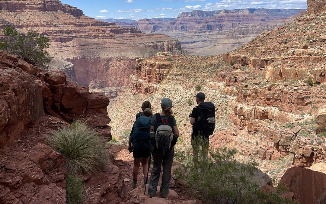
The next hour we hiked along the contours of the red walls, until we would reach Lookout Point. The trail was partly in the shadow, well defined and flat. We said: ‘Is that all there is to the Canyon?’, but we would be disproven later when fatigue would kick in at the Tonto Plateau. Anyhow, this part of the trail was quite easy and pleasant (but beware: the trail is just a feet away from a nasty fall at some points – stay focussed!).
We descended to a saddle above a distinctive red pyramid of Supai rock. Lookout Point: an expanded view into the canyon with the Tonto Plateau and the Hermit Creek visible in the distance. Lookout Point is roughly halfway to Hermit Creek, as well in time, distance and elevation change. An excellent point for a longer rest.

Lunch, Lookout Point, 1.452 m (4.764 ft)
The saddle itself was full of boulders. A few huge ones to climb for better views and smaller ones to serve as our picnic spot. We brought calorie-loaded food for lunch: leftover pizza from the Maswik Food Court and a dry frozen dinner each heated boiling hot water from our two stoves.
After an hour the sky became more and more overcast and we decided to move on.

View of the Colorado River and the Tonto Plateau
Section 4: to Cathedral Stairs
We followed the traversing trail along the walls, slowly descending to the rock layer that is called the Redwall. Now the Colorado River was clearly visible, as well as the massive Tonto Plateau. But before reaching the plateau, we had pass two major obstacles: a huge rockfall and a steep ‘DESCENT OF DEATH’ as my 12 y.o. jokingly referred to it.
My eldest daughter struggled with her knees though. Although well trained, she somehow wasn’t prepared for the constant and tough descent; the heavy pack didn’t help either. I gave her one of my trekking poles and she pursued bravely.
Half an hour from Lookout Point, the path has been swept away by a rock slide. Interestingly, the slide is all yellow rock, meaning that it must have fallen from the Coconino Sandstone layer high above. For several yards there is no trail at all, and careful bouldering is required to find the path again. The section is not particularly difficult, but focus and hands will be necessary.

Crossing the Yellow Rockfall
Just ahead of the rockfall, we finally saw a glimpse of the campsite at Hermit Creek. Especially two brightly shining solar panels (on top of the pit toilet) caught our eyes. Seeing our camp for the night was exiting for all of us, although we all wondered how on earth we could reach the place.
Breezy Point
Shortly after the rockfall, the trail became even more spectacular. We had arrived at a turn in the trail called Breezy Point. Being more than halfway into the Canyon, the views both up and down were breathtaking.

Breezy Point, 1.353 m (4,439 ft)
Our team got more and more dispersed by now: my two sons further ahead, me and my 12 y.o. daughter in the middle and my eldest in the back, fighting gravity and the pain in her knees.
Cathedral Stairs
We rested for a while at the saddle above the Cathedral Stairs, making sure to descend as a group again.

Descending the Cathedral Stairs, 1.332 m (4,370 ft)
The Stairs were not too bad: yes it was steep, and yes it looked scary, but in fact is was no more than 10-15 minutes on a solid set of switchbacks. Caution is needed and we all watched our footing carefully. Once at the bottom of the stairs, we looked up and we saw the landscape below us. The world was completely different now. Open, flat, and grayish-green. We had arrived at the Tonto Plateau.
Section 5: the Tonto Plateau to Hermit Creek
Just as we set foot on the somewhat dusty soil of Tonto, we met a mother and her teenage child who were climbing up. It was already past 3 a.m. and with only 5 hours of daylight left, I worried if they would make it to the rim before dark. Pro-tip: Don’t do this.
After traversing the slopes below Cope Butte for a while, a long zig-zagging path led us to the junction with the Tonto Trail.

Hermit Creek/Monument Creek Junction, 966 m (3,169 ft)
There is a wooden marker at the junction, pointing left (west) to Hermit Creek. I found my two youngest waiting at the sign. By this time the sky had become more and more overcast. I kept an eye on the clouds every now and then, hoping there would be no rain.
I also calculated that we had a maximum of 4 hours of daylight left. It was almost 4 p.m. and we were 30 minutes away from the campsite at Hermit Creek. The trail from our campsite all the way to the Colorado River and back would take us at least 2.5 hours (3 miles / 5 km out & back). This left us just about 1 hour of ‘fudge’ time and I did not want to take that risk, especially with most of us in the team being dead tired. So I decided Hermit Creek would be our journey’s end.

the Tonto Plateau.
We crossed the dry riverbed of an unnamed tribituary of Hermit Creek. Then we made one last long turn along a grey hill untill we saw the campsite close by. I made one last descent and then I saw my two youngest already smiling at the outhouse.
Hermit Creek Campsite

Hermit Creek Campsite, 900 m (2,953 ft)
Including rest stops it had taken us 7 hours to reach camp. I was proud of all my children and so happy to be in the Canyon with them – a long lived dream had come true after all.
Close to the outhouse were two group sites so we walked a bit further to a beautiful place near a huge rock, protected by two trees. We put our packs down and I changed my boots for flip-flops as quickly as I could. While others followed my example, I scouted for the best place to reach the creek below us. But my eldest son had already discovered a small trail down tot the water, a few yards downstream.
All our water supplies had run out by now, so we all scrambled down to the creek on flip-flops (a perfect and stupid way to sprain your ankles – which luckily didn’t happen).

Filtering Water at Hermit Creek
We took turns filtering creek water with the two Platypus Quickdraw Microfilters I brought (another pro-tip for canyon hiking: take two filters AND a Potable Aqua tables as a back up). The creek was beautiful and we all sat on the banks, listening to the babbling of the stream and enjoying the crisp cold water on our feet.

Hermit Creek Campsite
We went back to our camp to set up our tents (three in total) and designed a makeshift round table and chairs from the rocks. We ate our rehydrated meals is if we were starved, drank liters of water and decided to call it a day. Before 9 p.m. we all were sound asleep.
Day 2: Ascent to Hermits Rest
Start: Hermit Creek Campsite 900 m (2,953 ft)
End: Hermit Trailhead 2.024 m (6,640 ft)
Distance: 12 km (7.5 miles)
Elevation loss: 1.180 m (3,871 ft)
Elevation gain: 57 m (187 ft)Time: 4:46 h (8:00 h total time)
Rating: StrenuousHiked: April 28, 2025

Leaving Hermit Creek Campsite
I was the first to wake up at 6 a.m. I checked my bear canister to determine that our food and toiletries had not been eaten by mice or squirrels. I went down to the creek again to fetch water for breakfast, slowly waking my family in the process. We took our time for a good breakfast, feasting on various freeze dried cereals with oats and blueberries. We packed our tents, some of us took a mother nature’s shower in the creek and we filled our water bottles again, totaling 10 liters (2 liters each).
Section 5: Hermit Creek to Cathedral Stairs

Leaving the Tonto Plateau
By 8:30 everyone was ready to go. Our backpacks were technically lighter, as we had eaten a total of 10 meals by now. But we felt gravity pulling our packs with every step up the grey rocks. Leaving Tonto was especially hard, because a hot and fierce sun beat down on us, even at this early hour in springtime.
Section 4: Cathedral Stairs to Lookout Point
We returned to the Cathedral Stairs and we were actually happy to climb them, because they were mostly in the shadow. Now we knew the stairs were nothing to be afraid of and we made it up quickly.

View from the saddle above Cathedral Stairs, the Cope Butte ridge on the foreground left. Isis Temple and Buddha Temple far away.
At the top of the saddle we quenched our thirst. The first 2 liters of water must have been gone by then. Looking back we had an amazing view, much better than yesterday when clouds obscured the canyon. Behind the walls of Cope Butte an entire Canyon world was visible, with some major landmarks visible, like Isis and Buddha Temple 6 miles (10 km) or more away. The giant red rock was a perfect echo-wall and we started hollering funny words for a while until I reminded my kids and myself that it’s no good trail etiquette to make noise.

Yellow rockfall section
We made it back to the Yellow Rockfall. Coming from below, the complete streak of yellow rocks from above was better visible than the previous day. Knowing what to expect, the scrambling was easier and faster. But we needed much more time to rest and drink. I think we made twice as many hydration stops as on the descent.
Exactly at noon we arrived at Lookout point, again a perfect time for lunch. We all ate another complete rehydrated ‘dinner’, except me because I devoured a pound of cheddar cheese that was left.
I became somewhat worried about our water supply. We knew we were half way up, but we already drank way more than half of our water.
Section 3: Lookout Point to Santa Maria Spring
We began our Red Wall traverse, which was a nice variation from all the climbing before. But it seemed like the number of bends in the trail had doubled overnight. I told my children to hold on for just another 10 minutes, expecting the Santa Maria Resthouse just around the next corner. But it took us more than an hour (which is still a very good time for canyon hiking, by the way).

Red Wall traverse above Lookout Point
At the Santa Maria Resthouse my daughter took the Record Book and finished the drawing she began yesterday. The other rested on the wooden bench, while I was trying to figure out our water problem. We had no more than about one liter left by now and a long ascent before us.
I decided to filter the water from the spring. I placed a water bag under the slowly dripping pipe just to witness what I had known already: it would take far too long to fill the bag directly from the source. I needed to scoop up the water from the through below the source. The water in the trough was filled with strands of plant life and a hundred tadpoles. I scooped up the water very carefully, making sure none of these things would end up in my baf of water. I filtered four liters for the remainder of our hike. My kids made clear that NO way they were going to drink that stuff (but I knew they would).
Section 2: Santa Maria Spring to the Coconino Stairs
We had eaten the last of our supplies (nuts, cookies and Pringle Chips) at the resthouse except for a handful of gummy bears that would be life savers later on. We returned to several beautiful viewpoints we remembered from the day before – just one day, it felt like a whole week.
It was beginning te get really hot now: it was past noon and the trail provided less shelter. When we came to the paved stairway into the Coconino Sandstone, we optimistically thought the end of the trail was near.

At the bottom of the switchbacks
We arrived at the switchbacks about 45 minutes later. The canyon rim was clearly visible, but we had to hike for more than an hour to get there.
Section 1: Coconino Stairs

Original paved section of the Hermit Trail
This last section was gruesome for all of us. Even my two sons, who had struggled undisturbed throughout the entire hike, had now reached their lowest energy levels. They could hardly move anymore. But me and my youngest daughter were slower than ever and we sought shelter from the sun under every tree we passed.

Almost there!
On our last break together we all drank from the tadpole water and we ate my last gummy bears like they were manna from heaven. The last half hour was about to start.

Made it back to the Trailhead!
My sons arrived at the trailhead within 20 minutes. When I finally arrived with my 12 y.o., 15 minutes later, the other three of my children welcomed us with a COLD can of Coke (kept in the icebox in our car). That this was one of the best drinks in my life, goes without saying.
And thus ended one of the most impressive hikes of my life.
Read also: Grand Canyon, Escalante Route

0 Comments