The Fishermen’s Trail is an impressive coastal path in the south of Portugal, especially suitable for winter hiking. I did a beautiful hike from Porto Covo to Odeceixe in four days, where I found steep cliffs, sand in all colors and the deep blue Atlantic Ocean on my side all the time.
The Fishermen’s Trail (Trilho dos Pescadores)
Location: South Portugal
Start: Porto Covo
End: Odeceixe
Distance: 59,4 km (37 miles)
Elevation change: no more than 150 m (500 ft) per day
Time: 4 days (17,5 hours)
Hiked: February 2022
What is the Fishermen’s Trail?
Word has it that the Fishermen’s Trail (Trilho dos Pescadores) is the most impressive coastal path in the world. That might just as well be true. This multi-day hike in the south of Portugal is part of the Rota Vicentina, a collection of trails along the coast as well as inland. Originally the trail ran from Porto Covo to Odeceixe (this is the part that I hiked). Later it was extended all the way down to Sagres/Cabo de Sao Vicente, the southernmost point of Portugal.
Are you planning some epic coastal hiking? Keep in mind that Portugal is extremely hot and dry in summer and the trail has virtually no shade. I would absolutely not hike this trail between June and September. And while seawater is close by constantly, there are almost no water sources along the trail. I only crossed one tiny sweet water stream in 4 days, and found only 1 fountain – in the very last village. For your water supply you must rely on the guesthouses, restaurants and shops.

Overview of my 4 day Fishermen’s Trail itinerary.
Where to stay?
There are but a few campsites along the trail, and not always close to the trail. And do not expect to wild camp. Not only because it is mostly forbidden – even if you really want to, there are not many suitable spots near the trail and there are no water sources at all. So I stayed in guest houses and hotels and took my new ultralight frameless Zpacks Nero backpack with not much more than some clothing. Most guesthouses are easily booked online.
What to Pack?
I brought a light weight stove and some dehydrated food. I would be staying in guesthouses (all easily booked with Booking.com), but I wanted to be independent from shops and restaurants – which was a fine idea, so I discovered on day 3. Of course I could not bring gas in the airplane, but I found a store 15 minutes walking from the Sete Rios Bus terminal in Lisboa. Do not expect to find any other brand than the blue Camping Gaz – which will not fit your typical ultralight stove! I carried a small Camping Gaz stove instead, which was quite a bit heavier and bulkier than what I am used to.
The most important piece of gear was, as usual, my two water bottles. I filled them the first morning at my accommodation. But then I discovered I don’t like bleach water very much, so I switched to buying drinking water in shops – whenever I could find a shop that was open.
A reminder: I you go hike this trail, carry at least € 200 cash money, as not all guesthouses and shops will accept cards or sometimes the electronic payment just does not work.
Getting to the Trail

The easiest way to get to the trail is to fly to Lisboa (Lisbon) and take a bus to the village of Porto Covo. The bus terminal in Lisboa is called Sete Rios and can be reached from the airport by bus/metro, but I took a taxi for just € 10, which was worth it (really fast). From the bus terminal you can take the bus 78 to Sagres. Prepare for a long ride – the first stop is after 2 hours in Porto Covo.
My flight arrived in Lisboa at 4 pm, and I managed to get the last bus to Porto Covo, where I arrived at 8 pm, in an already dark village.
Day 1: Porto Covo–Milfontes
Start: Porto Covo
End: Vila Nova de Milfontes
Distance: 19,8 km (12.3 miles)
Time: 4:40 hrs hiking time, 5:50 hrs total time
Hiked: February 25, 2022
I stayed at the Calimaria Guest House located at the main road in Porto Covo, just a few minutes off the main village square. Breakfast was excellent: bread, fruit, eggs, yoghurt and even a special Portugese cake. I selected some of the food to take with me for lunch, before I took off on the trail.

Porto Covo village in the early morning light with the Atlantic Ocean at the end of the main street
I followed the road through the village until I reached the Atlantic Ocean. Welcomed by the powerful waves smashing on the rocks I headed south, starting the Fishermen’s Trail for real. I passed a tiny harbor and beach and climbed higher up the sand dunes.

The trail close to Praia Engardaceira, Porto Covo (the small island Ilha do Pessegueira in the background)
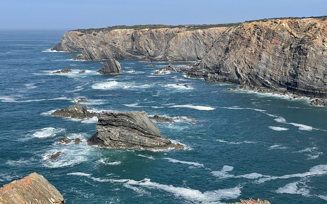
The trail passed many little beaches that were indicated on my GPS with a parasol-icon. In reality these beaches are sometimes not even accessible as they sit in very rough terrain. No parasols here! But the beaches are beautiful and impressive nonetheless. They reminded me of the steep cliffs at the island of Sark.
The trail turned to a broad and sandy beach for a while, where I passed the small island Ilha do Pessegueira and the old Forte da Ilha. Continuing higher up the cliffs again, I looked down at a violent sea pounding against the rocks so fiercely it terrified me.
The Fishermen’s Trail turns away from the seaside every now and then. The strange thing is: when you walk just 50 meters east (left), the landscape changes from fierce ocean cliffs to flat, pale green farmland. It gave me the feeling of hiking in my good old home country – not unpleasant, but after 30 minutes I got tired of it. So I checked my GPS to see if there was a trail closer to the ocean. I found an alternate trail and within minutes I was back in Portugal.

Praia dos Aivados
Later, when I came close to the Praia dos Aivados, the trail bent inland again. But again I found another trail that led me right to the beach, where I followed a straight sandy trail. Luckily the tide was low with the violent waves at a safe distance.
Following the beach trail, I arrived at the Praia do Malhao soon, where I caught up with the official trail again.

Looking back north at Praia do Malhao
Meanwhile it was getting really hot. My frameless Zpacks Nero backpack was small and light, but the foam back was sticking to my shirt with sweat and I began questioning my choice for this pack. My bigger and heavier 50 liter ArcAir that I have been carrying last year leaves plenty of room for breathing on my back (hence the ‘arc’). I learned that weight is not always everything.
Anyway, I passed more impressive bays, rocks and beaches until I arrived at Portos das Barcas, the long awaited and only restaurant on the route today. The restaurant was nice, but all the seats in the shadow were taken and after one drink I decided it was just too hot to sit here. I resumed my hike for one last half hour to Vila Nova de Milfontes, a little town where I had booked a room in the Duna Parc Beach Club. This room happened to be a complete apartment with separate bedroom, full kitchen, bathroom, private terrace and a shared swimming pool. Wonderful!
After jumping in the ice cold swimming pool I found a SPAR supermarket close by where I bought my dinner and tomorrow’s breakfast.
Day 2: Milfontes–Almograve
Start: Vila Nova de Milfontes
End: AlmograveDistance: 14,3 km (8.9 miles)
Time: 3:40 hrs hiking time, 5 hrs total time
Hiked: February 26, 2022
Accommodations along the trail can only be found in the villages, and these villages are all located about one day of hiking distance apart. This meant a short hike for today. The village Almograve is less than 4 hours away from Milfontes, while hiking on to the next village would take another 6 hours. So today would be a relatively easy day and I took all the time I wanted in the morning before leaving at 10 am.

Villa Nova de Milfontes
From the Beach Club I walked directly to the sandy beach and cornered a sandy bluff, from where I saw the village and the Rio Mira flowing into the ocean. I walked into the village passing the old fort, where a little boat took me to the other side of the bay for € 5. This saved me a one hour of asphalt hiking all the way around the bay, across a modern bridge. It also gave me the opportunity to see the village from the water, which made for a nice start of the day.

One of the many nameless rocky beaches along the trail that are impossible to reach.
On the other side the Praia das Furnas awaited me, with impressive black geological wonders next to the trail. I followed a meandering path away from the ocean, but as soon as I saw an opportunity I left the official trail to hike the much narrower path close to the ocean. The rocks were impressive: rough, crumbling and in all colors black, yellow, red. Halfway to the Brajo Largo, the broadest beach on the trail, I passed a tiny peninsula with a distinctive rock on top. I discerned a sandy path along the little isle, so I decided to look for a way to reach it.

The tiny rocky peninsula off-trail
I found a sketchy trail down to a narrow ridge that connected the land to the peninsula and in no time I climbed to the narrow top. I expected to see a birds nest, but I was all alone. Descending the pyramid I remembered that I have a fear of heights, so I made my descend as slow as I could.
Reaching safe grounds I searched for the trail and soon I found myself bushwhacking through dense vegetation. The trail was so much overgrown that I could not stand up straight and I had to use my trekking poles to clear the trail in front of me. I was happy when I saw the green-blue blaze, reassuring me I was doing o.k.

The green-blue blaze of the Rota Vicentina
Then the trail cleared out again and I found myself close to the long awaited beach of Brajo Largo. Climbing down a flight of green wooden stairs I soon reached the sands of a completely deserted beach. I found myself a shady spot next to the black rocks to change to my swimming trunks. The ocean was refreshingly cold but I did not dare to go in very deep. The waves were so high and powerful, I believe they could break a man in two.

The sandy beach of Brajo Largo
I spent half an hour on the beach before continuing the trail barefoot to the only exit point all the way south. There I dried my feet as good as I could and put on my boots to attack an almost vertical and slippery trail up. Back on the official Fishermen’s Trail I was less than an hour away from Almograve.

‘Vicentina Rooms’ in Almograve
In Almograve I stayed in a recently refurbished guest house ‘Vicentina Rooms’ – a name that quite accurately describes what it is. The friendly host gave me a choice between a big blue room or a smaller green one with a small shaded terrace. I chose the latter, longing for shadow. The room had a small fridge, but no facility to cook a meal. So I was glad I brought my stove and a home made dehydrated meal. A small shop in the village that opened up later in the afternoon provided me with yoghurt, sheep cheese, bread and fruit for breakfast.
Day 3: Almograve – Carvalhal
Start: Almograve
End: Carvalhal
Distance: 24 km (14.9 miles)
Time: 5:50 hrs hiking time, 7:10 hrs total time
Hiked: February 27, 2022
An early start: on the trail at 7 am. The morning air was quite a cold so after 10 minutes I donned my puff jacket and woolen beanie, only to put back in my pack once the sun had come out in full. I found a tiny trail close to the cliffs, that reminded me so much of the Californian coast.

Leaving Almograve on a sandy stretch of trail
The views of the cliffs were magnificent again. The sand was a brown-red which contrasted nicely with the dark green shrubbery on the side of the trail. The most common plant along the trail is the Hottentot Fig, which has thick green-and-pink leaves but has no relation whatsoever with a fig (nor Hottentots).

The Cavaleiro cutoff trail
When I came close to Cavaleiro, I wanted to avoid the long detour inland to the village. I tried an unmarked cuttoff trail to the bottom of a tiny canyon. I scrambled down along a steep path. At the bottom I crossed a small stream (the first fresh water along the trail) and I climbed back up to join the official trail again. I continued to the lighthouse Faro dol Cabo Sardao.
The next two hours I saw – aside from many secluded beaches and spectacular cliffs – a lot of storks sitting on high cliffs in the ocean and flying around in the fields. Before noon I finally reached the tiny harbor of Entrada da Barca.

Entrada da Barca harbor
A few minutes uphill from the harbor I came to the restaurant O Sacas, where I found shade and a cold drink. Unfortunately I was too early for the genuine Portugese dish of fried sardines I saw on the menu. Oh, I will just never get used to the southern European lifestyle where everything seems to happen in a different time-space-continuum. I enjoyed my Cola zero nevertheless and I let my feet rest for a while.
Leaving Entrade da Barca (not so much as a village but a cluster of restaurants and fishermen’s sheds) the toughest 2 kilometers of trail awaited me: a dead straight line of gravel directly next to the melting hot tarmac. The sun was at the highest point of the day and there was virtually no shade. No off-trail possibilities here so I just had to push on.

The road to Zambujeira do Mar
Shortly before arriving at Zambujeira though I found a side trail to the Pedra da Bica beach. I left the sweltering trail and ploughed my way through the sand dunes for half an hour to Zambujeira do Mar.

Cliffs close to Zambujeira do Mar
The village of Zambujeira do Mar was a bigger than the other villages so far and there were quite a few tourists around. I passed a lot of restaurants but I could hardly find a decent grocery store. A tiny and somewhat gloomy shop had some bananas and Coca Cola for me. I walked through the village to the beach where I had a short break, cooling my feet in the shallow stream that was finding its way to the ocean.
I ascended a steep cliff, taking off for the last 1.5 hours to today’s destination: Carvalhal. I wanted to go a bit further today, as to be sure to arrive at Odeceixe in time to catch my taxi and train back to Lisboa the next day.

Praia do Carvalhal
After hiking through a nice little coniferous forest I arrived at a wonderful lookout point with a panoramic view of the Praia da Carvalhal. A steep path brought me down to the beach, and then up again on a hot tarmac road to the resort of Monte Carvalhal da Rocha, where I had booked a room. The resort was all but deserted: I was the only guest and there were more stray dogs around than staff. But I was shown my room, an enormous tiled room with empty white walls and small windows. Not very beautiful, but the temperature was nice and cool. There was no kitchen though, and the restaurant and shop were closed at this time of the year. I felt very happy with the dehydrated food and stove I carried with me.
Day 4: Carvalhal – Odeceixe
Start:Monte Carvalhal da Rocha
End: Odeceixe
Distance: 14,3 km (8.9 miles)
Time: 3:20 hrs hiking time, 4 hrs total time
Hiked: February 28, 2022
A short day, but one with more elevation change, adding some variation to the hike. Sometime on rocky paths very close to the sea. At one point the trail went inland again, passing the estate of former fado-legend Amalia Rodriguez. A big white mansion, hidden behind trees. On the official trail sign a note was posted, stating that the next part of the trail was ‘dangerous’ and hence closed. There seemed to be no alternative trail however, so I decided to ignore the sign and I hiked on, using my Gaia GPS as a guide.

Praia da Amalia
The trail was a bit overgrown and had a moderately steep section, but there were no dangers (or closures as a matter of fact) of any sort. It was actually a very nice part of the trail, with a smal waterfall cascading from the rocks onto the sand of Praia da Amalia. Looking up, the Rodriguez mansion was visible, perched high on the cliffs.

Rota Vicentina sign indicating a narrow and more exposed trail off the main route.
A recurring theme of this trail was reconnecting with the official Rota Vicentina after a more interesting side trail. Again I rejoined the trail after the Amalia beach and I hike on the sandy trail along the cliffs.

Storks at Azenha do Mar
Soon I reached the small hamlet of Azenho do Mar, where I passed another restaurant (of course it was still closed at this hour). I walked down to the tiny harbor where I paused for a snack. I saw at least 6 storks nesting on the cliffs rising up from the sea.

On the cliffs of Praia de Odeceixe
It was only another hour of (off trail) hiking until I saw the ocean smashing the rocks for the very last time and I turned left, descending to the beach of Odeceixe. A mighty river cut off the beach, meandering into the ocean. I followed the trail to the river banks, where I took some time to cool off in the brackish water of the Rio Seixe.

Praia de Odeceixe-Mar
It took me another very hot hour of asphalt hiking to reach Odeceixe, because the trail winds all the way around the river to the only bridge crossing it, on the other side of the town. I arrived at the town square – with the one and only drinking water fountain – around noon, where I found a place to sit in the shade.

Odeceixe town square
I could not find any grocery shop within walking distance, but the water fountain and the last provisions in my pack were actually enough. I had made an appointment with Sílvia Novais Taxi a week before to take me to the nearest train station Santa Clara Saboia (about 45 minutes driving, € 50). Sílvia proved to be very trustworthy when she arrived at the town square exactly at 2 pm.
And thus ended my hike, driving through a hilly landscape with skinned cork oaks, yellow fields and faded sheds. The train took me to Lisboa in 2.5 hours, and when I was back in the crowded city streets I missed the silence of the ocean’s constant roar.
If you have any questions about this trail, please leave a comment below.
hi did you have to pre book guest houses or are the easy to book along the way
Hello Kieran,
I would recommend to pre book the guest houses. The distances between the villages are mostly a one day hike, there is no possibility to stay anywhere in between these villages (wild camping is not allowed, it’s a nature preserve). So you might as well plan ahead. Have fun! It’s beautiful!
Decathlon has all types of gas canisters now.
Wild camping is absolutely possible as many hikers do it.
Trail shoes plus short gaiters.
Thanks, good to know Decathlon has gas canisters!
As for wild camping: while it might be possible, I would not recommend it because it is illegal. The trail is inside the National Park Sudoeste Alentejano e Costa Vicentina and the environment is fragile, therefore I regard it not as resposible hiking to do so.
Hi I would like to do this trail the last week of Dec. Is it doable you think? In terms of weather, accommodation & restaurants. Thx S
Hello, I think the weather and temperature in December is comparable with February when I did this trail. Which is perfect for hiking.
Accomodations in the last week of the year might be either fully booked for Christmas and New Year – or they might be closed. I think you have to check that online. Have fun on the trail!
Thank you for the info. My daughter and I are doing trail from Porto Covo to Odeceixe. I do not have gps and wondered where you can get a map.
Hello Chris,
The trail is very well marked and because the trail is basically going all the way south, a detailed map will not be very practical or helpful in my opinion. 90% of the time there is only one way to go.
Instead of a map, I would recommend the Cicerone guide book “Portugal’s Rota Vicentina” (ISBN
9781786311436). It has a detailed description of the route plus simple maps of the route.
Have a nice hike!
What type of footwear did you wear for the Fisherman’s trail? I am concerned about the sand getting in my hikers and causing blisters.
Hello Laurie,
I wore high hiking boots. And you are right, sand coming into shoes is a real problem on this trail. The best protection will be to wear gaiters (I did not bring them unfortunately) and long sleeved pants. I had to empty my shoes at least twice a day!
Make sure to wear thick woolen socks in any case. Have fun, it’s a beautiful hike!
You inform me so well while you entertain me at the same time. That’s why I applaud for every blog you write.
Thank you so much!