Tiveden is one of 30 National Parks in Sweden. An old growth forest, strewn with huge boulders and dotted with smaller and bigger lakes, it offers good hiking opportunities. I combined four shorter loop trails to one bigger day hike.
Four Trails Tour in Tiveden
Location: Tiveden National Park, Sweden
Trails: Stenkälle-, Stigmans-, Oxöbergs- and Trollkyrkorundan
Distance: 12,2 km (7.5 miles)
Elevation gain/loss: 213 m (700 ft)Highest point: Trollportbergen (220 m /720 ft)
Time: 3:30 hrs walking time, 4:30 hrs total timeHiked: July 2021
How to Find Tiveden National Park
The park is situated between the two giant Swedish lakes Vänern en Vättern, on the border of the provinces of Västra Götaland en Örebro. It is close to the much smaller – but still vast – lake Unden, known for its amazingly clear waters.
The park is easily reached by car, from either the north-east or the south. You will see signposts from the highway. Be prepared to drive quite some distance on gravel road (but if you have been driving in Sweden for a few days, you should be grown accustomed to those rough roads by now).
There is no public transport to the park, without a car your only option would be a bicycle – or detouring from the nearby long distance trail Bergslagsleden.
The Trails
You can find detailed trail descriptions on the official trail map at the National Park’s website. Note however that the time required for each trail is highly overestimated on this map. For instance, 2 hours for the 2,2 km on the Stenkällerundan seems a bit odd. Even at a moderate pace you can easily cut in half the time mentioned in the description.

The official trail overview map of Tiveden National Park

I hiked a combination of 4 different smaller hikes to one solid day hike.
Main Entrance and Starting Point
The main entrance in the heart of the park has a small parking lot – make sure to arrive as early as possible, in any case before 10 a.m. The parking fills up quickly all days in summer. The word ‘Entrance’ suggests a physical entrance, with rangers and a ticket booth. But there is not even a simple fence; the park is free to enter, and so is parking your car.
There are (pit)toilets, visitor information on a big wooden wall, but no shop or restaurant or any other way to spend your money. But there is a water source to fill up your water bottle.

The Main Entrance of the park
Stenkällerundan
The Stenkällerunden (Stone Well Trail) is the shortest trail in the park. Marked as the yellow route, easy to find from the starting point, the trail offers some nice scrambling and short climbs in a terrain where trees and huge boulders intertwine.
The Stenkälle halfway the trail the is a little pool hidden under a massive glacial rock. The trail twists and turn underneath the boulder, and as you climb out you come to the short but steep side trail to the top of the rock, the Stenkälleklack. Unfortunately there are no real sights from the top, as the forest blocks all views.

Excellent waymarking throughout the entire park
Stigmansrundan
Halfway the Stenkälle trail turns around the rocks, where I followed the grey marked Stigman trail west. From here the trail was full of blueberry shrubs and swampy terrain. The trail is aided (and moss is protected) with wooden planks.

View of the lake Stora Trehörningen from the trail.
The trail leads to the Stigmans pass, which is confusingly marked on both sides of the gap in the rocks, where a gravel road passes through.
The pass also marks the junction with the next trail that I picked up, the blue Oxöberg trail.

The Oxöberg trail
The trail winds through the same mossy forest until the Tjäderskogen (wood grouse) waypoint. This information sign explains the grouse has an extremely loud and distinctive call. Until now I was woken up every morning by a loud cry, which must have the Tjäder. From here the trail slowly gets a bit less swampy and more rocky. Also the trees seem to open up a bit more, providing just a bit more views.
I passed the lake Gäddsjön, but could hardly see anything – all those trees in this forest!
But not much later I reached the beautiful Trollkyrkesjön, the largest lake on the Oxöberg trail. The lake is easily accessed from the trail all the way along its south -western shore. Because the temperature had risen quite a bit, I felt like going for a dive in the inviting clear blue water.

Trollkyrkesjön, a typical sky-blue Swedish lake, begging you to jump in.
Trollkyrkorundan
After a refreshing swim in the amazing lake, I connected with the last trail of this day, Trollkyrka trail, waymarked red. Trollkyrka means Troll Church, and the reason for this consists of two massive heaps of rocks along the trail. The first is very close and is called Stora (big) Trollkyrkan.

Stora Trollkyrkan is a huge pile of rocks in the forest.
I scambled up the Troll Church to find, to my disappointment, no view at all on the top. From here I began to meet more and more other hikers coming towards me, having started later in the morning, hiking counterclockwise.

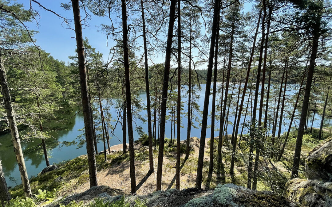
The rest of the Oxöberg trail reminded me of the first trail this morning, with some climbing, a lot of rocks and, at the end on the Oxöberg, finally something that can be called a view.
I arrived at the staring point just before noon put my head in the cold water of the water pump.
All in all, Tiveden National Park is a beautiful old growth forest. If you like hiking under the trees, the park offers excellent short hikes or day hikes, especially adventurous for the less experienced hiker. Personally, I missed hiking up to higher elevations, leaving the trees and reaching high passes with views miles away. But the lovely lake with swimming opportunity compensated for that.