Wilson Mountain is the highest mountain in the Sedona area. It is actually a mesa, and offers great views from overlooks at the north and the south side. I combined the North and South Wilson trails into one solid day hike.
Wilson Mountain Trail, Sedona
Location: Sedona, Arizona, USA
Trails: South Wilson, North Wilson
Distance: 11 miles (17,7 km)
Elevation gain: 2,660 ft (811 m)
Elevation loss: 2,450 ft (747 m)Highest point: Wilson Mountain South summit 7,011 ft (2.137 m)
Time: 5:15 hrs walking time, 6:30 hrs total timeHiked: November 6, 2022
Getting to the Trailhead
There are two trailheads for the Wilson Mountain trail: the North and South trailhead. The South trailhead has a small parking lot at the Midgley Bridge, the North trailhead has a bigger one at the Encinosa Picnic Area. Both parking areas are easy to reach from the US 179, but Midgely Bridge will fillup early.
If you want to hike a loop (you will have to hike on the US-179!), either one of the trailheads will do, but beware that the North trail is steeper than the South trail.

Overview of the Wilson Mountain trails
I did not hike a loop, but a point-to-point hike from the South trailhead to the North, visiting both of the Wilson Mountain overlooks at the plateau. I wanted to have my rental car at the end point (Encinosa Picnic Area), so I needed a ride from Encinosa to the trailhead Midgley Bridge early in the morning. This 3.4 miles of distance must be covered by car. It is only a 5 minute drive, and hiking would take an hour of dangerous road walking. The problem however was to find a reliable taxi service in Sedona. I had made an appointment with Sedona Quickrides but they just did not show up and despite the various messages I sent them, I never heard from them again.
So there I was at 7 a.m., my car parked on an almost empty parking lot with virtually no cell phone coverage. I waited about 20 minutes and I almost decided to change my plans for the day, when a white pick up truck parked close to me. Out came a man who walked in my direction, so I assumed he was the taxi driver. But he was actually just heading for the bathroom behind me. After explaining my confusion, he said he would take me to the South Trailhead at Midgley Bridge. The small but strong looking man introduced himself as Philip and in the 5 minute drive told me about his life as a native American, working as an electrician in Phoenix, 2 hours south, while his family lived at the Navaho reservation 2 hours north of Sedona.
Wilson South Trailhead

The South Trailhead of the Wilson trail is at the Midgley Bridge parking area.
Arriving at Midgley Bridge around 7.30, I looked around for the South Wilson trail sign. I found it just a few yards away from the Huckaby Trailhead, which leads down to the Oak Creek. The trail started on a quite steep path of red earth and rock, but soon followed the more gentle contours of the mountain. The colors of the ground beneath my feet seemed to change with every few steps. From red to yellow, then grey and brown.

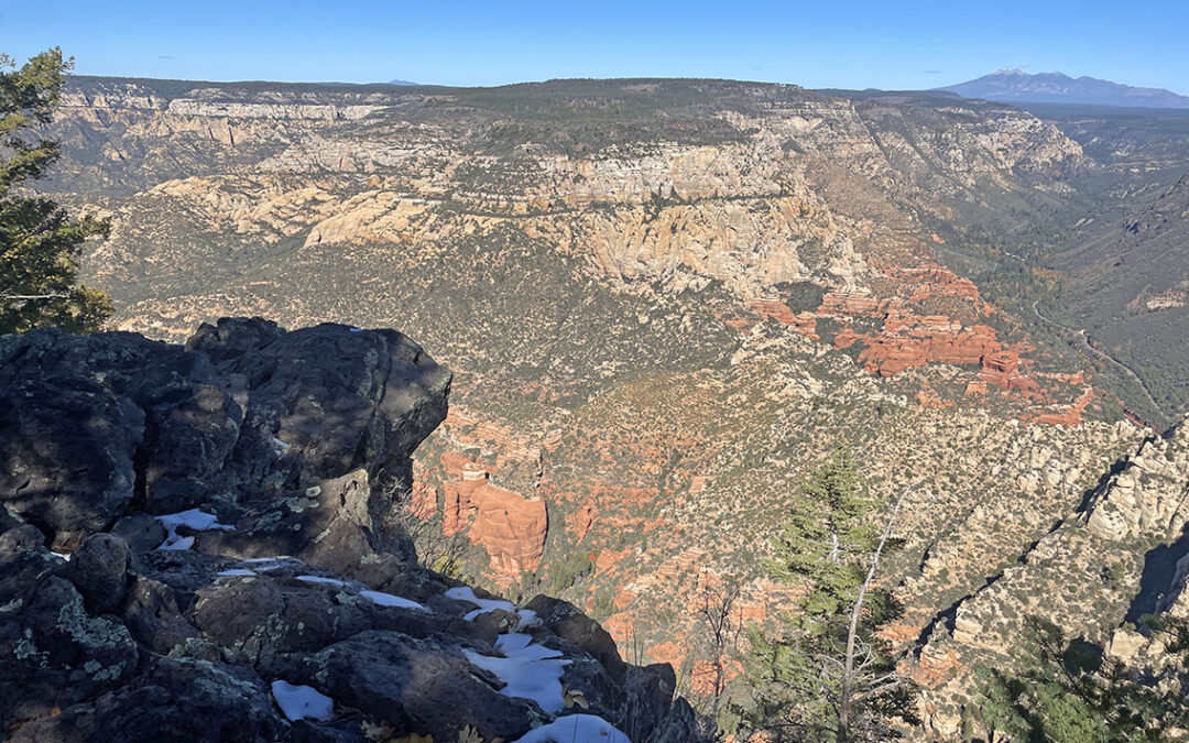
The Wilson Mountain plateau seen from the South
From the trail I saw the impressive Acropolis and Steamboat Rock to my left, touched by the first rays of sunlight on their golden-red walls. Around me: yellow grass, green shrubs on red earth and the pale green Agave plants. These Arizona colors will always stay with me vividly.
First Bench of Wilson Mountain
After 30 minutes or so the gradually ascending trail changed to more demanding switchbacks up to the higher plateau. I was hiking in the sun now and I stuffed my puff jacket into my backpack. In the distance, above me, I could see another hiker – the first of the day. While the Cathedral Rock hike the previous day had been somewhat crowded, today I was actually happy to meet someone else. After a while – the entire ascend took about 1.5 hour – I passed the man on the narrow trail. He was quite a bit older than me and I was somewhat worried about him at first (later I would learn he was a I very experienced hiker). We shared a short chat, but it was too hot to stand still here so I hike on to the top of the plateau.

San Francisco Peaks seen from the First Bench of Wilson Mountain
The top of the plateau, called the First Bench, is an enormous grassy field with only an occasional tree here and there. I stopped as soon as I reached one of these trees, providing me with some shade. I took off more layers of clothing, and rested a while sitting on a log.
To the north, the white snow caps of the San Francisco Peaks were clearly visible. These peaks are the highest in all of Arizona and together they are actually the remains of one giant eroded volcano. To the east the Oak Creek Canyon was visible. From this viewpoint it looks more like a canyon then when you’re inside of it, between the steep walls.
To the west the trail continued up to the next plateau, the actual Wilson Mountain top.

Trail close to the Wilson Mountain Summit
In half an hour I climbed up to the plateau on a narrow trail cutting through dense growth. There was snow on the shaded trail everywhere.
Sedona Overlook
The actual Wilson Mountain Summit is almost indistinguishable from the rest of the plateau. It is no more than a gentle knoll in the woods. But hiking on a bit further, I was rewarded with the spectaculair views from the South or Sedona Overlook.

Arriving at the Sedona Overlook (2117 m)
Coming out of the woods, the view was no longer obstructed by the pine trees and suddenly I could see 50 miles south all the way to the Mountains in Prescott National Forest, way beyond the city of Sedona just behind the red outcrops of Wilson Mountain.

View south from the Sedona Overlook
I sat down on a rock bench close to the ridge, looking down. I saw the Midgley Bridge in the distance and I couldn’t believe I had hiked all the way from there within 2.5 hours! Farther away, beyond the little specks of the Sedona buildings I saw Cathedral Rock, where I walked just a day ago. These are the magic moments of hiking: just sitting on a rock, looking around, noticing three black crows soaring on the rising currents of warm air.
North Overlook

Dead trees on the Wilson plateau.
Continuing the trail towards the northern overlook, I had to backtrack a short stretch of trail. Then I met the older hiker Craig from this morning again, and we hiked together all the way to the other side of the plateau. He told me he was 78 years old and had been living in a small truck for 16 years. He had been driving around the South West and hiking thousands of miles. He told me of his hikes in the Grand Canyon (10 days at the canyon floor!) and reassured me the the Tanner-Escalante Trail that I would be hiking next week would be very well doable.

North Overlook with San Francisco Peaks
From the North Overlook, the views were impressive again: the San Francisco Peaks in the distance and in the foreground the side canyon to Vultee Arch and Sterling Pass – where I would hike the next day. The terrain looked very difficult to negotiate. I studied the canyon for a while, trying to see a trail or the pass. I couldn’t find them but with help from Craig I did see the Vultee Arch, although from this viewpoint it was nothing more than a tiny slab of red rock.
North Wilson Trail
We backtracked to the trail junction to the First Bench. Craig would go back to the South Trailhead while I would return to my car at the North Trailhead. So our ways parted and soon I was heading down towards the other side of Wilson Mountain, and into side canyon of Oak Creek Canyon.

Descending from Wilson Mountain into Oak Creek Canyon
I descended on very steep switchbacks which demanded all of my concentration. But I had been hiking for 6 hours now and I was getting tired. I reminded myself to go slowly. Soon I reached a wooded area, which provided me some shade.

I followed a dry wash, under the cover of beautiful autumn shaded laves. Soon I could see the Encinosa Picnic Area with my car baking in the sun. The sight of a road and the sound of cars felt strange to me, as if I had been in the wilderness for much longer than just a day.
I found my car safe and sound and drove to the campsite, just a few minutes north on the US 179.

Manzanita Campground
This would be my first night at Manzanita Campground. I had made reservations a few months in advance, which was a good idea because the campsite was now fully booked. Still, it was not crowded and actually quite peaceful and calm. The camping hosts were very friendly and helpful and they kept the campsite really clean and neat.
I put up my Z-packs Duplex tent with the free standing kit: two long poles that keep the tent up as an exoskeleton. The ground was so rocky, I could not get any pegs in.
As soon as the sun disappeared behind the canyon walls – around 4 p.m. – the temperature dropped quickly and I needed two packs of fire wood to keep me warm until 7 p.m.
Thank you for this great map and your description of your hike! This is exactly what I am hoping to do. Do you think there are pros and cons of starting at the North Trail vs the South? Thanks so much!
The North trail is quite steep, and easier to descend than it is to ascend. Furthermore I feel that starting South makes for a more natural, slower approach to the top of the plateau. Descending North will be in the shadow at the end of the day, while the descend South will be sunny (this can be a pro or con depending on the season and your own preferences).
On the other hand, if you start North, and first visit the North Overlook, you will save the more dramatic South Overlook for the second half of your day.
Have fun!