The final part of the Kesch Bergell Trek was mainly a downhill hike, after the initial ascent to the Grevasalvas pass. From the pass I descended to an elevation of almost 2.000 m lower at my final destination in the village of Promontogno.
Trail Overview Part 4 (day 10–12)

Kesch-Bergell trek day 10 to 12: Julier Pass to Maloja, Vicosoprano and Promontogno.
Day 10: Julier Pass to Maloja
Start: Julier Pass, 2.233 m (7,326 ft)
End: Camping Plan Curtinac, Maloja, 1.800 m (5,906 ft)
Distance: 12,9 km (8 miles)
Elevation gain: 574 m (1,883 ft)
Elevation Loss: 1.009 m (3,310 ft)
Highest point: Fuorcla Grevasalvas, 2.688 m (8,819 ft)Time: 4:20 hrs moving time, 5:20 hrs total time
Date: August 24, 2021
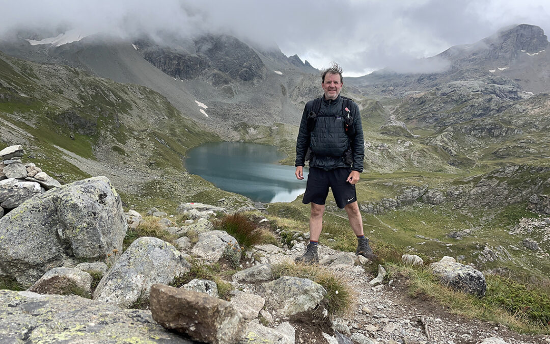
Lake Grevasalvas
Knowing that this last leg of my trek would be a lot less demanding, I slept in late, until 7:30 a.m. I had a grandiose breakfast in the dining room of Ospizio La Veduta, among the early truckers who were having their first coffee break. I collected bread and yoghurt for lunch, packed up and hit a foggy trail at 9 a.m.

Looking back to Ospizio La Veduta from the trail up to the Grevasalvas pass.
Crossing the road in front of the Ospizio, the trail winded steeply up into the green mountains. Due to the mist none of yesterday’s beauty was to be seen. At least I had witnessed it yesterday. Within an hour however there was more beauty to behold: the foggy mountains reflected in the lake Grevasalvas.

Leg Grevasalvas with Fuorcla Grevasalvas in the distance
The shiny blue water looked wonderfully tempting. I wanted so much to swim, but it was way too cold – I was wearing my hats and woolen gloves. The trail continued past the lake on a flat, swampy meadow, where I met the first other hiker of the day, a woman taking her time making photographs of the wildflowers. As I have experienced more often: the easier the terrain, the easier one picks the wrong trail. And so I lost track for a while, but finding the right direction was easy enough with the high pass ahead.
Grevasalvas Pass
The terrain changed from wet grassy meadows to steep rocks – but not too difficult, so the hike remained pleasant. The last ascent to the pass consisted of one giant pile of loose grey scree. A promising blue sky was awaiting me on the other side of the mountains, warming the Bergell valley.

Approaching Fuorcla Grevasalvas
It was 11 a.m. when I reached the pass Fuorcla Grevasalvas, two hours after leaving the La Veduta. The view was overwhelming, with an overview of the Bergell and the Bernina massif behind it. Low in the valley the blue water of the Silsersee could be seen, even today’s camping was clearly visible on its shore.
There was a comfortable wooden bench on the pass, on which I ate an early lunch, soaking up the view. Finally I saw in reality what I had been studying on the map so many times. So different from what I had imagined, and so much more impressive.

View from Fuorcla Grevasalvas (2.688 m / 8,819 ft)
Descending to Maloja
The descent from the pass was rough and rocky, with steep sections and huge boulders. It took quite some time to get through. Back on a easier trail, lower on the mountain, the scenery changed into a grassy meadow and a small black snake flew across the path. With each step the Bernina range slowly disappeared behind the walls of the Bergell. Herds of cows could be heard mooing and stood firmly across the trail later on.
I passed the sign to Duana lake and the Septimer pass. In earlier stages of the trek, I had considered hiking up there and to a hidden lake further on. That alternate, higher route in the Bergell is well worth mentioning though. Instead of hiking down to Maloja, the trail to the Lunghin lake (with wild camping options) will take you to the Lunghin pass. An interesting place, since it’s the only triple watershed in Europe, with water flowing to the Black see, Mediterranean sea and the North sea. From there, beyond the Septimer pass, a trail leads to the Duana lake (with more wild camp opportunities) and finally to Soglio.

View of the Silsersee from a lower trail
But, the weather forecast was very bad and already dense clouds were forming above me. So I decided to make the last part of my journey a bit easier for myself, and I continued on the path down to the hamlet Grevasalvas, a group of farms and stone sheds, with slates of granite for roofs.

Maloja at the Silsersee with Piz da la Margna above it
At lower elevation it was getting hotter and hotter; I was longing for a stream of cool water, but it seemed that I would have to wait until way down at the bottom of the valley, the Silsersee.
But after 2 full hours of descend, suddenly the trail went up again for half an hour. Luckily I found a roaring stream of cold water and I took off my shirt, soaked it in the water and directly put it on again. The best way to cool down and such a wonderful good feeling.

On the shore of the Silsersee
Then at 2 p.m. I stood at the Silsersee, exhausted from the last steep tracks. The sight of the town Maloja, with roads, cars, all the houses confused me a bit. The best I could do now was jump in the ice cold water of the lake – and I did.
A last kilometer of walking on the asphalt road led me to the camping Plan Curtinac, where I found a shaded but swampy spot, looking out to the mountains that I came from.

Camping Plan Curtinac at Maloja
Plan Curtinac is a hiker-friendly camping, with two general grassy fields for hikers to put their tents up. There are even some secluded spots in the woods. In the middle of all this sits a small café/restaurant with showers, and the middle part of the camping is packed with motorhomes and caravans. It can be a bit busy here, but the general atmosphere was good.
I relaxed the rest of the day with my book, food and drinks. In the evening I met another Dutch hiker who did lots of day hiking in the area. He told me his first thru hike had been a solo tour in the Himalaya (and now he runs a Himalayan Bag Shop). When the rain came we hurried inside the café for a drink and stayed until dark.
Day 11: Maloja to Vicosoprano
Start: Camping Plan Curtinac, Maloja, 1.800 m (5,906 ft)
End: Camping Mulina, Vicosoprano, 1.114 m (3,665 ft)
Distance: 11,6 km (7.2 miles)
Elevation gain: 35 m (115 ft)
Elevation Loss: 707 m (2,320 ft)
Highest point: Maloja, 1.836 m (6,024 ft)Time: 2:15 hrs moving time, 3:35 hrs total time
Date: August 25, 2021
From Maloja to Casaccia
The rain lasted all night and early in the morning it was still foggy and wet. I tried to stay in my tent as long as possible, knowing that this would be one of the shortest hiking day of my entire trip. When I had enough of reading and snoozing, I got up for a slow and relaxed breakfast. I brought all my gear to the covered area next to the café, where I reorganized and dried everything. The sun was chasing away the clouds and when I walked back to get my tent, the couple from the neighbouring tent had left a shiny red apple for me as a farewell present.

Latteria Maloja
My first goal was to find the one and only grocery in Maloja: the Latteria. The village feels like Italy and this tiny little shop had also adopted Italian opening hours: it closed from 12 to 3 p.m. I was late, but not that late, so I managed to provide myself with cookies and the usual yoghurt for lunch.
Now I was at the Maloja pass – an unusual pass, for it is completely flat on the east side and extremely steep on the west side. I followed the Sentiero Storico in the direction of Casaccia, a steep zig-zagging trail through dense pine forest.

San Gaudenzio ruins
Emerging from the forest I came to an asphalt road where I found a wooden picnic table beneath a big tree. These Swiss Italian cookies are truly irresistible, I found out during a short but high-caloric break. Continuing towards Casaccia I came along an impressive old ruin of a church, the early 16th-century San Gaudenzio. These kind of places always make me wonder: folks took such immense effort to build it, how come it was eventually abandoned?
Moving on, I passed the village Casaccia below me, and for the first time I could see deeper into the Bergell valley. Far in the distance the giant concrete wall of the artificial Albigna lake was visible. I followed a gravel road straight across a flat green meadow and turned right to reach the Sentiero Panoramico.
The Sentiero Panoramico

Sientero Panoramico, Maira river
The panorama trail turned left into the woods on the other side of the Maira river. I sat down in the shadow for a while and cooled down with my feet in the icy water. The rest of the trail made for a really relaxed hike with a moderate descend on a soft and shady trail through the woods.

Maira lake
I passed another nice surprise: the intense color of the Maira lake, which turned out to be a reservoir for power generation. But it was extremely beautiful nevertheless. Its shores were too soft and muddy to take a plunge though.

View from Roticcio on the Sentiero Panoramico
Along the Sentiero Panoramico there were indeed various panoramic views of the sharp edged granite mountains on the other side of the valley. Partly covered in clouds, they did not reveal their spectacular summits yet.

View of Vicosoprano and Mulina camping
And before I knew village of Vicosoprano was visible, with the Mulina camping in front of it, just a few minutes of hiking below me.
Vicosoprano
In fact I arrived so early (not even half past one), that the tiny campsite office was still closed for the siesta. But the weather was fine, the views were great and the campsite had an excellent shady shelter with tables and cold water flowing from a source. The ideal place to sit down and enjoy an afternoon of reading, writing and doing nothing.

Camping Mulina, Vicosoprano
I pitched my tent under a small maple tree, which gave me just enough shadow for my tiny tent. I noticed that there were many deciduous trees at this elevation (about 1.100 m / 3,500 ft). After all these days I had gotten used to pine trees so much, that I almost forgot the maple, birch and oak tree.
Day 12: Vicosoprano to Promontogno
Start: Camping Mulina, Vicosoprano, 1.114 m (3,665 ft)
End: Hotel Bregaglia, Promontogno, 823 m (2,700 ft)
Distance: 14,3 km (8.9 miles)
Elevation gain: 223 m (732 ft)
Elevation Loss: 509 m (1,670 ft)
Highest point: Vicosoprano, 1.114 m (3,665 ft)Time: 4 hrs moving time, 4:30 hrs total time
Date: August 26, 2021
Vicosoprano
Despite the idyllic setting I did not have a good night. Not only did I discover too late that my camping spot was not as level as I had perceived, the worst thing was the smoke. A lot of sites had fire pits, but few guests were able to build a good smokeless fire. The smoke was irritating my eyes and and some point late in the evening it felt suffocating.
Anyway, knowing that today’s hike would be short again, I could sleep in late. After a refreshing shower, I prepared my last self-made breakfast. My bag of food was empty now and I threw away my DIY Relfectix cooking pouch along with empty ziplock bags.

Vicosoprano
The campsite is actually situated 20 minutes walking distance from the actual village of Vicosoprano, a nice little hike trough the woods and meadows. Using Google Maps I found the village supermarket, which had just moved from a charming old building in the village to a newly built industrial and retail area south of the main road. I bought my lunch plus a local chestnut cake – this part of the valley is famous for chestnuts, they even sell ‘chestnut’ soap and body gels here.

Borgonovo
I followed the nice and easy trail mostly parallel to the Maira river and passed some interesting old villages, like Borgonovo. Today seemed to be more of a historic tour than a mountain adventure. Which was fine by me, for a last day on the trail.
Palazzo Castelmur

Palazzo Castelmur in Coltura
Halfway through today’s final goal, Promontogno, I came to the village Coltura, near Stampa. Another old and silent hamlet in the valley, with such an Italian feel to it, that it’s almost impossible to believe this is still Switzerland. I walked past an impressive pink castle, with crumbling stained walls. It had two towers, each with a piercing eye for a window in it. This was the Palazzo Castelmur. Later at home I found out that the castle was named after Giovanni Castelmur, who purchased the mansion around 1850. It was originally built in 1723. In 1961, the heirs sold the Castelmur property to the Coltura community and now it is a museum.

Ascending to Soglio, looking back to the Bregaglia mountain range
Leaving Coltura/Stampa, the trail went down easily. Because I was not really aware of the fact that Soglio was located a mere 200 m (660 ft) higher elevation, the final part of the trail proved to be unexpectedly tough.
A Last Steep Ascent to Soglio
To reach Soglio, one final steep ascent was to be conquered. Half of this consisted of steep rocky trail, and the other half were worn out stone stairs –about a thousand steps. In the meantime it had become extremely hot, and the shade of the trees brought only a modest solace.

Soglio with the Italian Alps in the background
But when I finally walked out of the woods I entered a green meadow, leading me to the lovely little village of Soglio. The white tower stood out firmly on a bluff, with grey-white thick walled houses around it.

Shady streets of Soglio
The village was quiet and empty at this hour. A few walkers were in search of the Hotel Palazzo Salis’ garden for a probably quite expensive lunch. I did not feel like mingling today and walked the narrow alleys of Soglio alone. I found the door of the high towered church open, and stepped inside the cool and even more silent sanctuary. A notable thing about this church is that it’s a reformed church, and was built in spite of strong opposition from the Salis family clan (yes, the Palazzo People).

View of Bondo and (left) Promontogno with Piz Cengalo in the right corner
It was time to leave Soglio and hike the last hour of my thru-hike to Promontogno, the twin village of Bondo. Descending another thousand steps, I came to a clearing whit a view of Bondo abd the Bondasca valley behind it. In 2017 a terrible disaster struck Bondo: a landslide from Piz Cengalo caused a massive river of mud and granite to sweep over the village, destroying many buildings, a bridge and all the trails up Val Bondasca. Eight hikers were killed in the events.
From up the mountain the village looked fragile and exposed to the giant mountains.
The End: Promontogno

Promontogno
Yesterday’s quietly babbling brook Maira had turned into a wild river now. I crossed one of the two bridges to the village of Promontogno, where I saw the aptly named hotel Bregaglia directly on the other side of the bridge. There was a bus stop in front of the hotel (handy!) and a Primo shop on the other side of the street (also handy!).

Hotel Bregaglia
The hotel was old and magnificent and I was happy to see there had been very little renovation to the building. I loved the old furniture and felt at home immediately. Time for a shower and a backpack shake out! Needless to say I did not do anything special anymore. I had finished my hike. I was excited and happy, and a bit sad.
The hotel served excellent basil gnocchi with Gorgonzola for diner, prepared like only the Italian can – excuse me, the Swiss! And thus ended my Kesch Bergell Trek. Next day I took the bus to Sankt Moritz, the train to Zurich and took my flight back home.
Kesch-Bergell Hiking Statistics
Total distance: 175,4 km
Total time: 56:45 hours of hiking, 12 days
8.638 m ascent, 9.347 m descent
Highest point: Flüela Schwarzhorn, 3.147 m (10.325 ft)
Lowest Point: Promontogno, 823 m (2,700 ft)
Mountain passes: 12
Summit: 1
If you have any questions about this hike, please leave a comment below!
< Previous: Kesch-Bergell Trek part 3: Parc Ela
0 Comments