Ending the Kesch Trek in Bergün, now the third stretch of my thru hike started. Hiking up to the Ela Hut, to Alp Flix and finishing at the Julier Pass, I traversed the entire Parc Ela in 3 days, with one of the most spectaculair passes of all: the Fuorcla digl Leget.
Trail Overview Part 3 (day 7–9)

Kesch-Bergell trek day 7 to 9: Bergün to the Ela Pass, Alp Flix and Julier Pass. Note that North is left.
Day 7: Bergün to Ela Hütte
Start: Camping Albula, Bergün, 1.400 m (4,593 ft)
End: Ela Hütte, 2.252 m (7,388 ft)
Distance: 8,5 km (5.3 miles)
Elevation gain: 1.005 m (3.297 ft)
Elevation Loss: 142 m (467 ft)
Highest point: Uglix 2.376 m (7,795 ft)Time: 3 hrs moving time, 3:40 hrs total time
Date: August 21, 2021
Leaving Bergün
Today’s goal was the Ela Hütte. I had not made a reservation for the night, assuming that while the hut was uncatered and unmanned, there would always be place for me. In the morning I felt a bit insecure about my plan though, so I called the hut and found out that the hut is not unmanned in summer, and they were fully booked! I thought it would be the best just to hike to the Ela hut anyway and hope that they would let me camp near the hut. Otherwise I could hike further up to the other side of the Ela Pass and find a wild camping spot at one of the lakes.

View from Bergün’s main street: Piz Ela is the tiny summit in the middle
But first I went to the Volg supermarket at the village square (actually the only serious supermarket on the entire hike, until the last day in Vicosoprano). I stocked up on food for the next one and half day with bread, cheese, yoghurt, chocolate and a meal of beans.
The trail started in the green meadows above the village, not particularly steep, but it was sweltering hot. As I progressed the woods higher up the trail provided a bit of shadow, but the moist air was like a heavy blanket around me and I had trouble keeping my pace.

The Tinzenhorn from the Uglix meadows
As I reached the higher meadow Uglix, some fresh air made the trail more bearable. But this was not one of my best days and ascending more than a thousand meters in one go was strenuous. At one moment I reached a high point point and the pyramid of the Tinzenhorn appeared above the green grass. Finally I seemed to get somewhere.
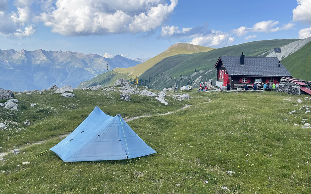
The Ela Hütte
One last look at Bergün and the descend began on the other side of the grassy hill. Now the entire mountain range came into view and the Ela Hütte appeared as a tiny speck in the middle. With my goal clearly in front of me, the rest of today’s trail suddenly seemed so easy and this put me in a cheerful mood.

Ela pass (left) and Tinzenhorn rise high above the Ela Hütte
It was only 2 p.m. when I arrived at the Ela Hütte, so I might have hiked up the pass and find me a wild camping spot before the evening. But with the spectacular views all around the hut, this seemed a perfect place to spend the rest of the day.
I found the friendly Bewärter (hut warden) at the table in front of the hut. Although there was a clear ‘No Camping’ sign attached to the wooden beams behind him, he said it would be no problem if I put up my tent here. I offered him to pay for the water and use of the toilet and for 20 Swiss francs I was allowed to use all the facilities at the hut, including the kitchen.

View from the Ela Hütte
Although the hut did not provide meals, there were cooled drinks for sale! I sat down at the table with a Coca Cola, took off my boots and relaxed for the rest of the day.
A woman was coming down from the Ela Pass, running. She sat down for a drink and told me she came running all the way from Samedan (about 3 of 4 mountain passes away) and was on her way to Bergün to take the train back. I was baffled, for Samedan would have taken me at least 2 or 3 days to hike to.
Various groups of mountaineers came by, returning from the Tinzenhorn summit. Within a few minutes the whole site was full of climbing gear, ropes, helmets, bottles and an occasional mountain bike. They disappeared as quickly as they came into the valley.

Ela Hütte
After a while it was getting too hot at the table in front of the hut so I sat down in the shadow on the other side, reading my book. Guests were arriving now, one large group and some couples and pretty soon the hut resembled a busy downtown café.
I ate a simple meal of cold beans (‘Mexican salad’), a handful of mixed nuts and half a bar of white chocolate as dessert.

My tent below the Ela Pass near the hut
Finding a level camping spot was not so easy. Most of the terrain was steep and very rocky. I took my time and after weighing all pros and cons of two possible sites, I settled down quite close to the trail. When I had everything set up, my sleeping pad was still not level at all, but at least the ground was soft with grass.
After some more reading, I fell asleep to the murmur from the hut close by.
Day 8: Ela Hütte to Alp Flix (Sur)
Start: Ela Hütte, 2.252 m (7,388 ft)
End: Sur, 1.544 m (5,066 ft)
Distance: 20,2 km (12.6 miles)
Elevation gain: 948 m (3,110 ft)
Elevation Loss: 1.660 m (5,446 ft)
Highest point: Ela Pass, 2.724 m (8,937 ft)Time: 6:30 hrs moving time, 8:10 hrs total time
Date: August 22, 2021
Ela Pass
It was about 4 a.m. when strange flashes of light outside woke me up. The Dyneema fabric of my Zpacks tent is so thin, that moonlight easily shines through. I saw bright flashes in the distance from across the valley: a helicopter? Someone’s flashlight in the hut? Or was it lightning? I opened the fly of my tent to take a better look and I concluded that if is was a thunderstorm, rain would probably be here soon. I decided to pack my tent now it was still dry and have an extremely early start on the trail.

Approaching the Ela Pass with a view of Piz Ela
Before 5 a.m. I was ready to go. Although the moon had disappeared behind clouds, it was light enough to hike without my headlamp. The trail was rocky and the last stretch to the pass quite steep, but it was actually spectacular in the faint light of dusk. Near the pass the 3.338 m (10,951 ft) Piz Ela dominated the scene.

View from the Ela pass
It took me about one and half hour to reach the Ela Pass (2.724 m / 8,937 ft). When I finally stood next to the yellow sign it was 6:30 a.m., the sun was rising and the darkness gave way to an impressive view of the mountain range on the other side of the Oberhalbstein valley. Right in front of me was the first (unnamed) lake of three lakes below the Ela Pass.
Although there was a very steep direct route down to the second lake (Lai Mort), I took the easier route to the right, leading me to the first lake. Descending, a chamois ran across the steep wall on my left, racing away from me.

Unnamed lake below the huge Pizza Grossa
It was a perfect time for my breakfast now. I found a flat grey rock to sit on above the turquoise water, with a view of a massive brown-grey mountain (called Pizza Grossa, 2.937 m / 9,636 ft). The sky was clearing on this side of the pass, and I was happy that I had started so early this morning. Eating bread and cheese from the Volg in Bergün I experienced one of those perfect moments in the mountains. Everything was silent, fresh air energized me, the view of the dramatic mountains and lakes promised a beautiful day.
Cotschna Valley to Alp d’Err

Cotschna valley
Moving on, I passed the next lake (Lai Mort) and I saw Lai Grond in the distance. My backup plan to camp here would not have been very comfortable, I realized. The terrain is rocky, muddy and no level spot to be seen. I descended further on a really steep trail when the weather turned and suddenly I was hiking in mist and rain to the Cotschna valley, where a fairly flat path took me to the next valley: Alp d’Err.

Private hut in Val d’Err
The weather got worse and worse – it rained so hard that my rain suit started to fail. My shirt was wet with either sweat of rain and I began to get really cold. Then, not far away, I saw a wooden cabin. A mountain hut? A shelter? I headed toward the front door, I needed to be out of this torrent as soon as possible. The official Parc Ela sign next to the door made the hut look like designated shelter. I tried the door, it was open and I stepped inside. Two pairs of shoes and lots of clothes were lying on the floor, and I asked aloud if this was a hut. ‘Ja, aber privat!’ was the answer from the bedroom to my right, were I saw two young people barely awake. I rushed out the door apologizing.

Approaching Furschela da Colm
By some kind of miracle the rain had stopped at least it was no more than a soft drizzle, while I had been inside the private hut for just one minute. Outside I changed my wet shirt for my dry and warm merino sleeping shirt, hoping the change would get me a bit warmer again.
Alp Flix
I hiked up a green meadow called Parsettens and soon reached another waymark simply called Punkt 2450, where a 10 minute side trail started to the mountain top Piz Colm. The strange thing of this Piz was that it was actually lower (2.415 m) than the Punkt 2450 I was standing at. As it was still quite misty, I did not bother doing the side trail and continued to Falotta (2.460 m), where the final descend to Alp Flix started.

Alp Flix
Descending Falotta was a joy, after so many hours of climbing in bad weather. The clouds were subsiding to make room for a modest sun. According to my somewhat outdated guidebook Bergtochten In De Zwitserse Alpen by Jolanda Linschooten, there should be plenty of places to have a drink in the little hamlets on Alp Flix. The trail ended in Tgalucas, right on the premises of Cotti Coltura, a well known cafe/inn and tourist magnet of the area. I sat down exactly at noon – after 7 hours of hiking. I had a delicious apple juice and a not-so-good Nusstorte while I dried out my rain gear and backpack in the sun, watching at all the day hikers just about to start their hike.

Descending to the village Sur
From Tgaluca I walked 5 minutes west to the village of Cuorts, where I found the trail to Sur, my destination for today. I had booked a room in Hotel Edelweiss at the bottom of the village, which meant I had to descend another 500 m (1,650 ft). According to the sign this would take met 45 minutes, but the trail ran pleasantly along a fast running creek and within half an hour I was at my hotel Edelweiss. I spent the rest of the afternoon washing my clothes under the shower with douche gel, shaking out my entire backpack to reorganize my stuff and tracing my tour on the map.
Dinner was fine, a typical Swiss Rösti, which is a simple grated potato meal with a truly excellent Möhl Apfelwein, which is a Swiss appel cider and the best thing I ever drank in my life.
Day 9: Alp Flix (Sur) to Julier Pass
Start: Sur, 1.544 m (5,066 ft)
End: Julier Pass, 2.233 m (7,326 ft)
Distance: 13 km (8 miles)
Elevation gain: 1.188m (3,898 ft)
Elevation Loss: 502 m (1,647 ft)
Highest point: Fuorcla digl Leget, 2.711 m (8,894 ft)Time: 5:30 hrs moving time, 6:50 hrs total time
Date: August 23, 2021

Hotel Edelweiss, Sur in the early morning
The night had passed with a pelting rain and lightning, which made me a happy man. Initially I had a plan to wild camp somewhere above Alp Flix. With these torrents, that would have been a disaster. This became especially clear when I walked through the meadows above Alp Flix a few hours later.
Hotel Edelweiss served the best Bircher Müsli I tasted in a long times and the landlady revealed the exact recipe to me. When it was time to go I took an egg, some bread, yoghurt and cheese for lunch and at 7:30 I was outside to set the first step of a 1.167 m climb to Fuorcla digl Leget.

Back at Alp Flix, now seen from the east side
A muddy trail on Kanonnensattel
The ascent was steep, wet and stuffy from the evaporating rainfall beneath the tree cover. But the trail was silent and beautiful. After one hour I was on Alp Flix again. Heading east to higher elevations the mist returned and visibility was reduced to nearly nothing. In the company of many herds of cows, I slowly crawled up through the muddy trail to Kanonnensattel, a grassy saddle. The idea to camp here turned out to be really foolish. The saddle did not have one level spot, it was rocky and extremely muddy. And there must have been grazing two dozens of cows at least. Actually, the trail consisted of 50% cow dung.
Besides all these practical objections, it was actually forbidden to camp at Parc Ela anyway. So My decision to stay at the hotel in Sur had been a good one.

On the way up to the Leget Pass
The scenery changed from grass and mud into grey rock, and the mist was slowly dissolving. About 4 hours into my hike I met the first other hikers above Kanonnensattel. Two ladies in their sixties had come from the Leget pass and the Julier pass on the other side. It was good to talk to them – although I like to hike alone, I like to hear from other hikers what they have experienced on the trail.
Fuorcla Lake and Pass

Trail of huge rock slabs up to the Leget pass.
Leaving the grass, the trail continued on slabs of rock, a welcome change to my feet. My new hiking boots (Hanwag Tatra) had been put to the test in an extreme way: immersed in soaking wet grass for more than two hours. But unlike last year on the Haute Route, my feet were still dry. Before this thru hike I had greased the shoes with special wax and apparently this worked well.

Fuorcla digl Leget and Lai Leget on the left.
The pass was amazing. With the mist moving silently above the waters, the pale turquoise lake Lai Leget looked mysteriously beautiful. I sat along its shores for a while, watching the water and the rocks change colors as the clouds moved.

Lai Leget
This morning I had been dreading the lengthy climb, but Fuorcla digl Leget turned out to be one of the most impressive passes I’ve ever set my feet upon.

On top of the Fuorcla digl Leget
The actual pass at 2.711 m (8,894 ft) was a few minutes further east from the lake. On the other side the sky was clearer and spectacular mountain ranges came into view. The trail was going down steep, sometimes dangerously steep. It was remarkable that many fairly old people came walking up to the pass. I’m talking about 70 or 80 year old hikers, mind you! These people are an impressive example to me and I hope I will be able to hike such steep mountains, decades ahead.
Val d’Agnel

Corn Alv touching the sky
A striking rock was rising up: Corn Alv, with 2.980 (9,777 ft) not the highest of summits, but surely the most impressive in the Val d’Agnel. It reminded me of the granite rock towers in California.
When I reached the crossing to the Jenatsch Hütte and Preda, the trail became fairly flat and today’s goal came in sight: the Julier pass.

Val d’Agnel and Julier Pass
I had returned to an elevation with green grass and many purple alpine flowers welcomed me back. From far away, I could see the sun reflecting on the tin roof of Hospiz La Veduta. It would only be another hour or so before I could indulge in a soft bed and a hot shower there.

View from La Veduta of the Julier pass
It was 2:30 pm when I jumped on the spotless white sheets of my carefully made bed in La Veduta. The room was big, light and the large balcony offered a view east and north. Just like in many hotels before on this trip, I was the one and only guest in th Hospiz. So I had the shared showers and bathroom all to myself. For dinner I had a plate of Spätzli, a Swiss egg-noodle pasta with, again, a most refreshing half liter of Möhl. In the evening I planned the final fourth part of this thru-hike and I determined the village Promontogno in the Bergell valley as my final destination. I made a reservation at the Hotel Bregaglia – 3 days ahead of today.
If you have any questions about this hike, please leave a comment below!
< Previous: Kesch-Bergell Trek part 2: Kesch Trek
> Next: Kesch-Bergell Trek part 4: Bergell
0 Comments