The Kesch-Bergell Trek part 2 consists of the spectacular Kesch Trek. A four day hut-to-hut mountain hike. Because the first hut on the route (the Grialetschhütte) was closed all season, I hiked the trek in 3 days. And I included the ascent of the 3.147 m high Flüela Schwarthorn at the start.
Trail Overview Part 2 (day 4–6)

Kesch-Bergell trek day 4 to 6: Flüelapass to the Scalettapass, Chamanna d’Es-cha and Bergün
Day 4: Flüelapass to Scalettapass
Start: Flüelapass, 2.383 m (7,818 ft)
End: Scalettapass, 2.606 m (8,550 ft)
Distance: 16,4 km (10.2 miles)
Elevation gain: 1.345 m (4,413 ft)
Elevation Loss: 1.138 m (3,736 ft)
Highest point: Flüela Schwarzhorn, 3.147 m (10.325 ft)Time: 7 hrs moving time, 9 hrs total time
Date: August 18, 2021
The Flüela Schwarzhorn
I woke up with a dense mist above the lake Lai da la Scotta next to the Flüela Hospiz, blocking all views. No mountain was visible, and especially the Schwarzhorn, my first goal for today, was nowhere to be seen.
Yesterday evening I wanted to fill my water bottles, but there was no drinking water from the tap – there were big ‘Kein Trinkwasser’ (no drinking water) signs in the bathroom. What I use to do in such a case, is take my Sawyer to filter the tap water. But when I got to work, my filter was completely clogged! I ordered a new Platypus QuickDraw filter online – to be delivered a few days ahead in Bergün. Without my water filter, I just took the risk and filled up my water bottles with the ‘kein Trinkwasser’ this morning (in this post about my gear list you can read more about gear failure).

Looking back to the Flüela Hospiz and pass
At 7:40 a.m. I was on my way, I crossed the road and followed the trail a bit higher on the other side of the pass. It led me to the smaller lake, Lai Nair. Interestingly, this lake spills into the Danube river, while the bigger Lai da la Scotta on the other side spills into the Rhine, making the pass a watershed between water flowing west to the North Sea and east to the Black Sea.

Trail to the Schwarzhorn
In 15 minutes the trail crossed the paved road again, now ascending into the mountains towards the Schwarzhorn. Today there were no cows but an abundance of curious sheep on the trail, questioning me with their tilted heads: what are you supposed to do here? Indeed a good question, because most of the time I could not see more than 50 meters in front of me. And when the mist cleared rain, snow and hail started to fall from the dark sky. I began to doubt my plan to climb the Schwarzhorn summit (read my article for The Hiking Club blog about embracing the bad weather).

The trail crossing below the Schwarzhorn
When I reached the trail crossing to the Schwarzhorn side trail, I decided to stay with my original plan. The summit would be 1 hour up and 30 minutes down, and this effort would provide me with a new personal altitude record in Europe, the first summit above 3.000 m. So I followed the steep and rough trail up to the snowfields, hiking deeper and deeper into the mist.

The Schwarzhorn summit, 3.147 m (10.325 ft)
As I climbed higher the mist became even denser until I really could not see more than 2 meters in front of me. The sharp rocks to my left and right acted as a fence between me and an unfathomable depth. Then suddenly a large wooden cross loomed in front of me: I had reached te summit. There were no views whatsoever, I was completely contained by the white mist. In a metal box fixed to the cross I found a Gipfelbuch and a Bergbibel. In wrote my name and the date in the Gipfelbuch. The mountain bible was a compilation of all bible texts that relate to mountains. And although I am not religious at all, I could appreciate the gesture of the person that brought the book here.

Overview of Chant Sura valley on the left and the scree from the Radönt glacier on the right
The Radönt Pass
Descending the Schwarzhorn summit back tot the crossing, I met a few other hikers going up. Just like me they persisted in their effort, despite the thick clouds above. At the trail crossing the sky was more or less clear. I could sea the Chant Sura valley in the distance and a massive field of scree to my right. A faint line crossed the grey mass: this was my trail to the next pass: Fuorcla Radönt.

Unnamed tarn below the Radönt Glacier
Continuing from an elevation of 2.800 m at the trail crossing, it was actually a net descent to the pass, as the Fuorcla Radönt sits at a 2.788 m. altitude. Walking through the scree slope it was lovely to have some views again, and a marvelous one this was! I passed an azure blue tarn, fed by an invisible glacier above me.

View south from Fuorcla Radönt to the Grialetsch glacier, Piz Vadret (3.291 m) and Piz Grialetsch (3.120 m) on the right
Reaching a mountain pass where an entire new valley and mountain range presents itself is always the highlight of the day for me. With two oval shaped tarns below me, this new world seemed to look me straight in the eye.
Fuorcla da Grialetsch
Following the trail down seemed easy. But without yellow signs nor red-white markings, I slowly began to doubt wether or not I was on the right track. When the trail went down steeply I decided to check my GPS, and discovered that I was on my way down to the Grialetsch valley, while I wanted to stay high as long as possible. I backtracked steeply and found a red-white mark on a boulder. I was on the trail again – or so I thought. The path suddenly vanished and for the next hour I would be scrambling a huge and difficult boulder field.

Hiking down to the Grialetsch Hütte, below Piz Grialetsch
When te boulder field came to an end I lost track again twice. But eventually I found myself on a nice and clear trail, crossing a grassy hill. In the distance the Grialetsch Hütte came into view, located next to a beautiful lake. I knew the hut was closed because of building activities. Still I hoped to be able to get some drinking water there. I had already used up a lot of water, and there would be no water source at the shelter on today’s destination – the Scaletta pass.

Grialetschpass and hut (almost hidden behind the hill on the right, Grialetsch glacier in the background
For the second time today I was descending to a mountain pass, this time a mere 300 m. lower: the Grialetschpass (2.537 m / 8,323 ft). So it didn’t really feel like reaching a pass when I got to the yellow sign. I was very anxious to find some water, but alas: a group of other hikers just returning from the Grialetsch hut said that everything was closed.
Hiking on I passed the Furggasee, a beautiful lake, tempting me to jump in. But it was getting late and I still had a major stretch of trail before me.

Hiking along the contours of the Dürrbodenberg with the Chüalphorn and (invisible) Scalettapass below it, on the far left
The trail took me lower and lower, which made for an easy hike right now. But I knew I had to win back all this lost elevation soon, when I would be hiking up the Scalettapass. I followed the trail down to the Dischma valley, but when I reached the point where the trail turned right to Dürrboden, I took a left turn, following the sign to the Scalettapass. I was delighted to see a ‘hut’ icon on the sign, because I had not found any official confirmation yet that there would indeed be a hut on the pass. Now I felt reassured about that, I only had to take care of my water problem.
The Scalettapass
I found no source or water fountain anywhere on the trail, and when I was finally hiking up to the pass, the chance I would find one was small. For this situation I had brought my water filter – but I had left my clogged filter in the garbage bin of the Hospiz, while the new one was to be delivered two days ahead. So I studied my map in detail to find the highest possible stream that I would pass on my way up. I would get my water there and use it unfiltered.

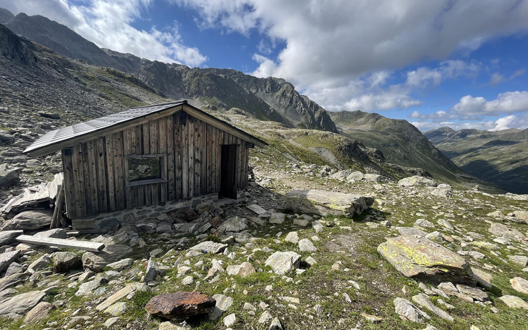
The Scaletta pass, 2.606 m (8,550 ft)
Just 10 minutes below the pass, while the roof of the shelter was already visible, I filled up my 2 liter water container from a small, clear stream. No cows or sheep up here – this water should be safe.
I reached the pass at 16:30 to find an excellent shelter all for myself. The wooden hut is large enough to sleep 3 or 4 people and has two tables with benches along the wall. Two windows with a view to both sides of the pass complete the scenery. There is no water or electricity and no (pit) toilet, so it takes some preparation and improvisation. But this is a truly magnificent place te spend the night.

Looking back from the Scalettapass and the schutzhütte, with the Schwarzhorn in the center
Looking back north, the Schwarzhorn peak stood firm in a cloudy but blue sky. It was only 6 hours ago that I was on the misty summit and now I could see all the way back.
Day 5: Scalettapass to Chamanna d’Es-cha
Start: Scalettapass, 2.606 m (8,550 ft)
End: Chamanna d’Es-cha, 2.594 m (8,510 ft)
Distance: 21,6 km (13.4 miles)
Elevation gain: 1.171 m (3,842 ft)
Elevation Loss: 1.182 m (3,878 ft)
Highest point: Fuorcla Pischa 2.871 m (9,420 ft)Time: 7:20 hrs moving time, 8:50 hrs total time
Date: August 19, 2021
The fifth day of my thru hike would turn out to be the most challenging of all. Ironically I would finish at almost exactly the same altitude as from where I started – with a steep 1200 m. down and up again in between.

Early morning view of Val Funtauna below the Scalettapass
The night had been bright and full of stars, so I was confident this would be a dry and sunny day. I was on the trail before 7 a.m., leaving the pass and connecting to a high trail contouring the mountains above Val Funtauna. There is also a trail descending into this valley, but aiming for the Kesch Hütte it is smart not to lose height.
I passed a small stream coming up from high in the mountains, and I guessed this stream must also be safe enough to drink. I had no other choice anyway, so I filled my bottles with the ice cold clear water.

The twin mountain tops Aguoglia d’Es-Cha (3.379 m) and Piz Kesch (3.406 m)
The trail was only slightly going down for about two hours. After a while it was low enough for herds of cows again, using the trail for their own convenience. After an hour or so the massive black Piz Kesch came into view. Its twin peak is called Aguoglia d’Es-Cha. The white mass is the glacier Vadret da Porchabella; there is an alpine route crossing this glacier that brings you directly to the hut on the other side: Chamanna d’Es-cha.
Which brings me to an interesting phenomenon in this part of Switzerland. Multiple languages are used next to each other in the geographical names. Not only Italian and German but also Rätoromanisch (which comes in different dialects). So it is not surprising to find many different words for the same geographical features on maps and signs, like:
Aguoglia, Piz, Horn = mountain top
Fuorcla, Pass = mountain pass
Vadret, Gletscher = glacier
Chamanna, Hütte = hut
Lägh, Lai, See = lake
The Kesch Hütte
Anyway, while I was ascending a short steep trail to the Kesch Hüttte, the mighty Piz Kesch slowly disappeared from view until I was at the top of the pass Fuorcla da Funtauna. I had reached the Kesch Hütte.

View west from the Kesch Hutte with the massive mountain range of Piz Ela (3.329 m) back on the left
At the hut I met a mother and daughter who were going to hike to Chamanna d’Es-cha via the alpine route. They assured me that this route had very exposed sections and was suitable for experienced alpine climbers only. I was happy taking the ’normal’ route trough the valley and up to another pass.
After a cup of hot chocolate it was still before 10 a.m. when I left the hut. There was no drinking water at the hut by the way, so I hiked on with the water I had collected in the stream this morning.

Descending from Kesch Hütte
Hiking down a beautiful path I finally found a water fountain in a meadow next to the trail. The first ‘officially’ potable water since I left Berghaus Vereina two days ago! But I was wondering: the water from this fountain must come directly from the glacier. So why would the water in the hut be any different, as it must come from the same source? Later today I would be talking with a local hiker about this matter (spoiler: there is no difference).
The Fuorcla Pischa
Before noon I reached the crossing to Chants, where I turned left for the Plazbi valley, which would lead me to the next pass: the Fuorcla Pischa.

Val Plazbi looking towards Piz Üertsch (3.265 m)
Passing Alp Chants, a small farm in the valley, the trail was still relatively flat. To my right I saw the high green mountains topped by Piz Darlux, and a dark wall of rock looming in the distance. My initial plan for tomorrow had been to hike back from Chamanna d’Es-cha over the Pischa pass, following the ridge to Piz Darlux and descend to Bergün from there. But now I understood that such a route would be hellishly hot – no shadow and very steep, and to be honest, a bit boring. So I changed my plans and decided to hike the normal ’Kesch Trek’ route through the Albula valley tomorrow.
But first I had to overcome the grueling ascent before me.

The trail to Fuorcla Pischa with Piz Blaisun in the center
The trail became remarkably steeper and soon I was zig-zagging my way up through dry and grassy fields. The sun was burning and there had been no shade for about two hours now, and there would be none for the rest of the day. I reached a massive field of scree. The trail was well marked, but the loose rocks and gravel were difficult to negotiate. I could see the tiny silhouettes of people at the pass ahead. It took me an hour of plodding through the rocks to get there.

Fuorcla Pischa 2.871 m (9,420 ft), looking back west to Piz Ela in the clouds
The final push to the top of the pass was extremely steep. And dangerous because of the snowfield that covered the pass at both sides. I was exhausted when I reached the top. The last hour of tiresome scrambling had put me in a bad mood and for the first time I didn’t like this hike anymore. All I wanted was some shade, but looking down the eastern side of the pass I saw that there would be none soon.

Descending from Fuorcla Pischa, looking back at the silhouette of a hiker that would be one of my room mates in the hut.
The descent was steep and the trail was rough. I crossed an enormous field of grey rocks again, and later an entire part of the trail was devastated by recent rockfall. Scrambling on, my mood was not getting any better. The massive grey mountains seemed a menace to me and all I wanted was get out of this place.
Chamanna d’Es-cha

Chamanna d’Es-cha, high above Val d’Es-cha
Slowly the landscape became less dark until I was surrounded by green fields again. Then the hut came into view. It was 4 a.m. – two full hours after the pass – when I finally reached Chamanna d’Es-cha.
The mother and daughter who had taken the alpine route were already enjoying drinks and snacks on the terrace in front of the hut. They told me the route had not only involved challenging glacier crossing, but also dangerous abseilen (rappel) from an icy wall.
The hut was very fine and provided everything I needed. Drinking water. A shower. Outlets to charge my phone. Food and drinks. Shade. And of course great views all the way to the snow capped Bernina range, with the 4.000-plus meter high Piz Bernina.

Chamanna d’Es-cha (2.593 m / 8,507 ft)
I shared a room with three other solo hikers: a german hiker, a Swiss girl that was hiking back home to the valley and the hiker I already saw at the Pischa Pass. His name was Wan and he was a Chinese student in Zürich. The four of us had dinner together on a separate table in the dining hall. The Swiss girl told me that the water in huts is actually perfectly safe to drink; the ‘Kein Trinkwasser’ signs are merely a legal obligation. Also, all streams that are high enough above grazing fields can always be considered a secure source of drinking water.
After diner we taught Wan how to play Uno, together with a Dutch family and we had a lot of fun.
Day 6: Chamanna d’Es-cha to Bergün
Start: Chamanna d’Es-cha, 2.594 m (8,510 ft)
End: Camping Albula, Bergün, 1.400 m (4,593 ft)
Distance: 19 km (11.8 miles)
Elevation gain: 101 m (331 ft)
Elevation Loss: 1.260m (4,134 ft)
Highest point: Chamanna d’Es-cha, 2.594 m (8,510 ft)Time: 4:30 hrs moving time, 5:40 hrs total time
Date: August 20, 2021
Today’s trail was surely the easiest part of the Kesch Trek. After descending to an elevation as low as 1.400 m (4,593 ft) at Bergün, I reached the end of the Kesch Trek, and I was halfway my thru hike.

Chamanna d’Es-cha in the morning sun
Up before 6 a.m., showered, dressed and packed at 7 a.m., I was ready for breakfast. While this meal was a bit meager (the muesli was too watery), the lunch package that I bought was very good (apple, bread and cheese and 2 chocolatebars).

The last view of Piz Bernina and Piz Morteratsch before everything disappeared into the fog
Getting ready for the trail, my room mate Wan chose to stay a bit longer to enjoy the views. How right he was! As soon as I descended I was surrounded by fog and lost all views for the next 2 hours.
Val d’Alvra

Turning the corner to Val d’Alvra
Hiking in the fog is a bit odd. I knew there were spectaculair views around me, as I had seen yesterday. But now I hardly saw the trail in front of me. But, as they say, a bad day on the trail is better than a good day at the office. This is especially true in the Alps in my opinion. I enjoyed the almost perfect stillness of the mountains as I descended the narrow trail step by step.

The Albula Pass (2.315 m / 7,595 ft)
After about two hours I reached the Albulapass – another pass I had to descend to, a recurring theme this thru hike. There was a lot of construction work going on at the pass. It was busy and noisy, this was not the right place for a break. I found back the trail behind a construction fence and continued into the Val d’Alvra (Albula valley).

Val d’Alvra, Piz Ela (3.329 m) in the clouds
On the other side of the Albulapass the clouds were mostly gone. A sunny valley lay before me, with the big Piz Ela welcoming me.
Palpuogna Lake
I had a break next to a small waterfall looking out over the mountain range and a small lake below me. It was getting hot now, and I relaxed my feet in the ice cold water before moving on to the Palpuogna Lake.

Looking back east from Lai da Palpuogna with Piz da las Blais and Piz Dschimels in the background
The Palpuogna lake is wonderful, with its turquoise waters and green forest around the shores. But: no swimming allowed. As a matter of fact I’ve never seen so many prohibition signs (except maybe in Rifugio Bertone during the tour du Mont Blanc). Of course I understand: the area is visited by thousands of people and the beautiful lake needs some protection. And I wholeheartedly agree with the banning of drones in the area. But how I would have loved to have taken a dip in the water.

Bergün
The next two hours I descended further to the village of Bergün, sometimes quite steep. The trail passed some impressive railway constructions. As a matter of fact, the trail is called the ‘Bahnerlebnisweg’ (Railway Adventure Trail) from here on. If you’re lucky, you can see the iconic red trains above or below you.

Camping Albula, Bergün
The camping Albula is located about 1 km (0.6 mile) south of the village Bergün. The trail leads directly past the camping. There was a car free grassy field for tents with a covered picnic table and fireplace. Across a small bridge I found the showers and a small kiosk. The rest of the camping has RV’s and caravans and a couple of small wooden houses. All in all it was a fine, but not spectacular camping. After setting up my tent, I walked to the village (10 minutes along the main road).

Bergün village
The village of Bergün has many very old buildings, in a typical style that has an Italian feel to it. I visited the supermarket at the village square and later sat down in the shaded garden of Hotel Ela. It was still quite early in the afternoon, so I took my time to write, tracing my progress on the map and plan my next few days.
Back at the camping I made myself a good hot meal, trying to master the fire in the fireplace and not succeeding. The wood was too wet and there was smoke everywhere. Nice try though – this was my first night camping and I wanted a fire so much. At least all my clothes smell like smoke now.
If you have any questions about this hike, please leave a comment below!
< Previous: Kesch-Bergell Trek part 1: Vereina
> Next: Kesch-Bergell Trek part 3: Parc Ela
0 Comments