Departing from Tanner Beach, the first part of the Escalante Route is pleasantly easy. The second half, starting with the Dox Traverse, is more strenuous but offers the most impressive views of the Grand Canyon.
Escalante Route Day 2: Tanner to Escalante Beach
Start: Tanner Beach (2,700 ft / 823 m)
End: Escalante Beach (2,560 ft / 780 m)
Trail: Escalante Route (unmaintained)
Distance: 9 miles (14,5 km)
Elevation gain: 1,407 ft (429 m)
Elevation loss: 1,516 ft (462 m)
Time: 5:10 hrs moving time; 6:20 hrs total time
Date: November 12, 2023

Escalante Route day 2: Tanner Beach to Escalante Beach
Tanner Rapids
I slept quite well on the soft sands of Tanner Beach. The night was cold though. Underneath my ‘20-degree’ quilt I wore every single piece of clothing I had, except my rain gear and shoes. With an almost full moon it was never really dark; I could follow the moon’s westward movement during the night as I woke up every now and then.
At the first daylight, around 6 a.m., I got out of my tent. I didn’t need to dress, because I already was fully clothed and it was way too cold for a wash in the river.
After my visit to the open air pit toilet (the only one on the entire hike that has an, so after my visit there, I freshened up, brushed my teeth and I was ready to make my breakfast. The oatmeal didn’t taste good. Later I found out I had put too much alum in the water yesterday, trying to accelerate the sedimentation.
Around 8 a.m. I was ready to leave and start the Escalante Route for real.

An early morning fisher downstream of Tanner Rapids
I followed the sandy trail along the river, passing a few campsites. A group of hikers was getting ready for their way back up the Tanner Trail today. I seemed to be the only one heading west on the Escalante Route.
When I reached a spacious sandy area, I lost track for a couple of times and had to backtrack. Aided by my GPS app I found the trail again underneath the willows and tamarisk shrubs.

View of the Colorado River with Vishnu Temple in the background
With the sun risen above the canyon rim, the temperature was getting more comfortable as I hiked on, accompanied by the roaring sound of the Colorado River. What a wonderful morning!
The trail was mostly flat now, but faint in some places. Sometimes all I could rely on were a few footprints left by one or two hikers in the dusty red soil.

Faint trail towards Cardenas Beach
Cardenas Beach
The red sandy trail was undoubtedly the easiest part of the entire 5 day hike. Within 1,5 hours I reached Cardenas Beach, another breathtaking oasis in the desert. I think it was even more beautiful than Tanner Beach. No surprise some Escalante Route hikers choose this as their first night camp instead.

Cardenas Beach at the Colorado River
It was still early (9:30 a.m.) and I already covered one third of today’s hiking distance, so I decided to take a long break at this beautiful beach. I unfolded my little chair and unlocked my bear canister for some food. The next half hour I enjoyed the view of the red rocks and the soft murmur of the river flowing by.
Anasazi Ruins
From Cardenas Beach the moderate ascend to Dox Traverse started. Hiking up the first hill – Dox Hill – I followed the main trail to the right. But (at least on my GPS map) there is also a trail to the left, that leads directly to the highest point of the hill. On this high point sits the ruin of an Anasazi building. Following the right hand trail I almost passed the ruin, but contouring the hill, I scrambled up some rocks from the south side to find the ruins on top.

Anasazi ruin on the Dox Hill.
The ruin was bigger and better preserved than I had imagined, being about 1200 years old. Looking at the ruins I wished I had known more about the history of the Anasazi people in this area. All I knew was they lived here around 800 AD and actually grew crops in the Unkar Delta. Looking down on the land below I tried to imagine what it would be like living here. If only the rocks could speak.
I scrambled down to the narrow trail south of the hill through the red sandstone. The trail approached the steepest cliff along the entire trail, following the flow of the river about 650 ft (200 m) below. I was now on the Unkar Overlook.

View of Colorado River and Unkar Overlook
The trail was flat and wide enough as well as 5 yards away from the cliff’s edge. It was never dangerous, however this was not a place to walk backwards trying to make a selfie. Hiking further I looked back and only then I saw how steep the overlook actually was.
The Dox Traverse
The trail continued on a field full of little cacti, with tiny yellow hairs shining in the sunlight like halo’s. The trail seemed to aim for a dead end towards a steep and dark ridge. I was walking above an unnamed drainage (or side canyon) and I had to hike all the way to the point were it was possible to cross to the other side. The steep slope seemed impossible to negotiate and I wondered how on earth I would ever get to the end of it. I had no choice but to put my trust it the sparse cairns on the side of the trail. Turning 90 degrees to the west I started the exposed traverse below the ridge, all the way to a crest that I would not reach until 1.5 hours later.

Towards the Dox Traverse / Escalante Creek ridge
This section is referred to as ‘a traverse below the ridge north of Escalante Creek’ by the National Park Service but called the Dox Traverse by some hikers – I adopted the latter name. The Dox Traverse was, in hindsight, one of the most difficult parts of the Escalante Route – yes, more intimidating than the feared Papago Wall and Slide. Exhausting because of its length and demanding because the steep slopes required a constant alertness.

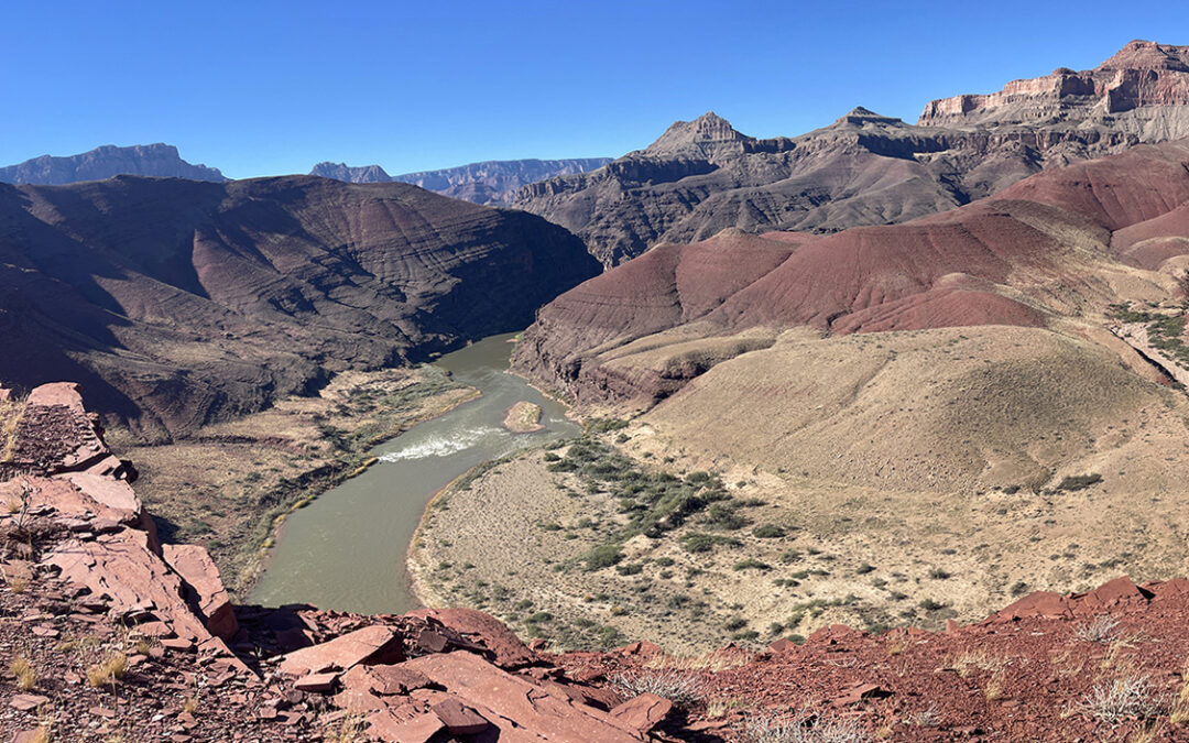
Colorado River and Neville Rapids as seen from the crest above Escalante Creek
When I finally reached the crest at the end of the traverse I was awarded with a view beyond words. To the left: grey cliffs marking the beginning of the dark Granite Gorge with the whitewater of Neville Rapids below. To the right the red sandstone cliffs of the Unkar Delta with views beyond Tanner Beach. And looking down there was Escalante Creek canyon waiting deep in the shadows.
Escalante Creek
I descended from the crest to the Escalante Creek bed. Suddenly I was on the sunny and hot south side of the ridge. I took off some layers of clothing and paused for a while in the shadow of a huge boulder before heading on. It is not possible to follow the dry creek all the way to the Colorado River, because of a deep fall halfway. So the trail crossed the creek bed to the other side, ascending towards an impressive side canyon.

Escalante Creek side canyon
Following the dry creek bed in this side canyon for a while, the trail changed to some sort of a slot canyon, with a winding path between narrow walls. The trail ended abruptly at another (dry) fall: a 150 ft (50 m) deep drop-off that was impossible to descend. I wondered how to proceed but then I realized I was off trail again – I backtracked 20 yards and found the trail to the other side of the canyon.

Escalante Creek mouth
Hiking down the last 10 minutes to the Escalante Creek mouth I met a group of four hikers from Flagstaff – the first human beings I saw that day. Although it was already past 2 p.m. (that’s about 4 hours of daylight left) they hiked on to tackle both 75 Mile Canyon ànd Papago Wall to eventually camp at Hance Rapids tonight. A doable, but to me a somewhat rushed itinerary.

Escalante Beach at sunset
A few yards downstream of the creek mouth I found the most astonishing beach on a secluded bay. A group of 4 ladies had already picked the spots on the first half of the bay, but there was more space a bit further. I set up my tent in the soft sand below a willow tree, just a few yards from the sea – excuse me: the river. This was a tropical paradise inside a canyon: waves coming in calmly while I walked around on my bare feet. I was tempted to go in for a swim but I thought it wise not to because undercurrents in the water can be dangerous. I went in up to my knees and rinsed the icy water over my body. What a place! What a day!
> Previous: Day 1 – Lipan Point to Tanner Beach
> Next: Day 3 – Escalante Beach to Hance Rapids
Thanks immensely for this clear and complete blog.
My husband and I hope to hike the escalante route this year in May, if the wheather is not to extreme.
I am looking into how to reserve campgrounds on recreation.gov. However, I cannot find a campground called escalante beach on the reservation page.
If I understand correctly from your overview
Did you stay overnight:
– 1st night BB9 tanner
– 2nd night ?
– 3rd night near BD9 red canyon
– 4th night Hance creek
A document from nps.gov does mention Escalante
Creek (BC9), however it is also not listed among reservation options. In several blogs I read about overnight stays on Escalante beach, and I can also find it on the map. Or should I just make reservations for Cardenas Creek (BC9) (same code) do you know if this means we can camp on escalante beach then
Hopefully you can help me here
Greetings from the Netherlands, Joan & Louise
Hello Joan & Louise,
Thanks for your comment.
The campsites and codes are: 1st = Tanner BB9; 2nd = Escalante Beach BC9; 3d = Hance Rapids BD9; 4th = Hance Creek BE9.
As far as I know you should reserve EXACTLY the place where you will camp.
Recreation.gov won’t let you book some remote campsites due to difficulty. Hikers must contact the Backcountry Permit Office (grca_bic@nps.gov) directly to get the right permits.
I hope this works out for you.
Hartelijke groeten en veel plezier, Pieter
Ha Pieter,
Thank you for your response.
We managed to reserve the pitches. And are now going to prepare for the adventure.
Thanks for your clear blog, it will definitely come in handy for us.
Goede reis!
Hi Louise,
How was the trip? I am planning the same itinerary for the end of April ’26 and should get the permit this week. Did you follow Pieter’s route suggestions and camp areas? What is your thoughts on the 4 vs 3 nights?
Thank you