A sunny sixth day on the Haute Route: I hiked along an incredibly blue lake to Col de Sorebois. Leaving the amazing view of the mountain range east I decended to the village of Zinal, where I found the first campsite of my thru hike.
Haute Route 6: Cabane de Moiry to Zinal
Start: Cabane de Moiry, 2.814 m (9,232 ft)
End: Zinal, 1.678 m (5,505 ft)
Distance: 22,7 km (14.1 mi)
Elevation gain: 549 m (1,801 ft)
Elevation Loss: 1.689 m (5,541 ft)
Highest point: Col de Sorebois, 2.832 m (9,291 ft)
Time: 6 hrs moving time; 7 hrs total time
Date: August 5, 2020

Haute Route day 6: Cabane de Moiry to Zinal (base map layer by Gaia GPS)
Cabane de Moiry
A very good night in Cabane de Moiry. Quiet and not too hot in the 4-bed dorm. I woke up just two minutes before my alarm went off at 6 a.m. Although today would not be a very strenuous hike, I wanted to be early to avoid crowds at the shower and breakfast. But there was no one waiting for the showers and downstairs at the common room there were only a few early risers preparing breakfast.
Fully packed except for my hiking boots I sat down for an excellent breakfast with the original Bircher muesli as they can only make it in in Switzerland. There was toast, orange juice and tea and a view of the glacier catching the first rays of sunlight.

Early morning at Cabane de Moiry
Outside was a clear blue sky and for the first time I was able to see the mountain tops above the glacier that were obscured by clouds yesterday. It was a few minutes after 7 am when I started my hike to the Moiry valley again. In the clear morning sun the path down looked so different from yesterday. Not a menacing steep trail anymore, but a spectacular walk down along the hairpin corners.

Looking back to Glacier de Moiry
I hiked down for a while with the American guest from yesterday evening’s dinner. She was living in Switzerland with her family – that’s why she was probably the only American on the trail (due to Covid there were no other Americans this year at all).
Lac de Moiry
At the junction of the trail to the lakeshore and the high trail around the lake, we passed a yellow sign to the cabane that was pointing completely the wrong way (down instead of up). My American companion had taken a wrong turn here yesterday (and an unnecessary detour). So I learned that even the meticulous Swiss signage can be wrong sometimes. I turned the yellow sign around until it was pointing toward the cabane again.

View of Lac de Moiry from the high trail along the lake.
Hiking along the incredibly blue lake, we heard a constant hum of helicopters flying above. They were going back and forth between a platform at the lake and somewhere in the mountains, on the other side of Col du Tsaté. The heli’s were not rescuing unfortunate hikers, but they were hauling big metal fences for a construction that they were apparently building.
It was about 9.30 am now and after 2.5 hrs of hiking I took a break for an early lunch or late breakfast snack with a magnificent view of the lake. Although it was nice to have companion on the trail, it was o.k. to be alone again when my American companion hiked on to the barrage below.

Lac de Moiry from above the barrage
The trail along the lake is quite flat until close to the barrage, where the trail splits. To the left the trail descends to the barrage and hut, the right hand path leads up steeply to the Col de Sorebois. I was tempted for a moment to go down and visit what seemed to be a restaurant with inviting red parasols. But I didn’t want to loose altitude and besides, I wasn’t even hungry or thirsty. So I hiked further up among the cows that were grazing freely in the meadows.

The trail was passing a free cow range and about two dozen of cows and calves were suddenly running down together. I halted for while to let them all pass. When I hiked on, a black mother cow that was descending later than the rest, was crossing the trail. Suddenly she ‘bluff charged’ me, protecting her calf. Luckily I was far enough and the cow walked down without further trouble.
Col de Sorebois
Now the sun was appearing above the mountain tops, and with no shadows anymore it was getting freaking hot in the pasture. It would take me about an hour of steep ascent to get to the col.

View south from Col de Sorebois with the Weisshorn (4.505 m / 14,780 ft) on the left
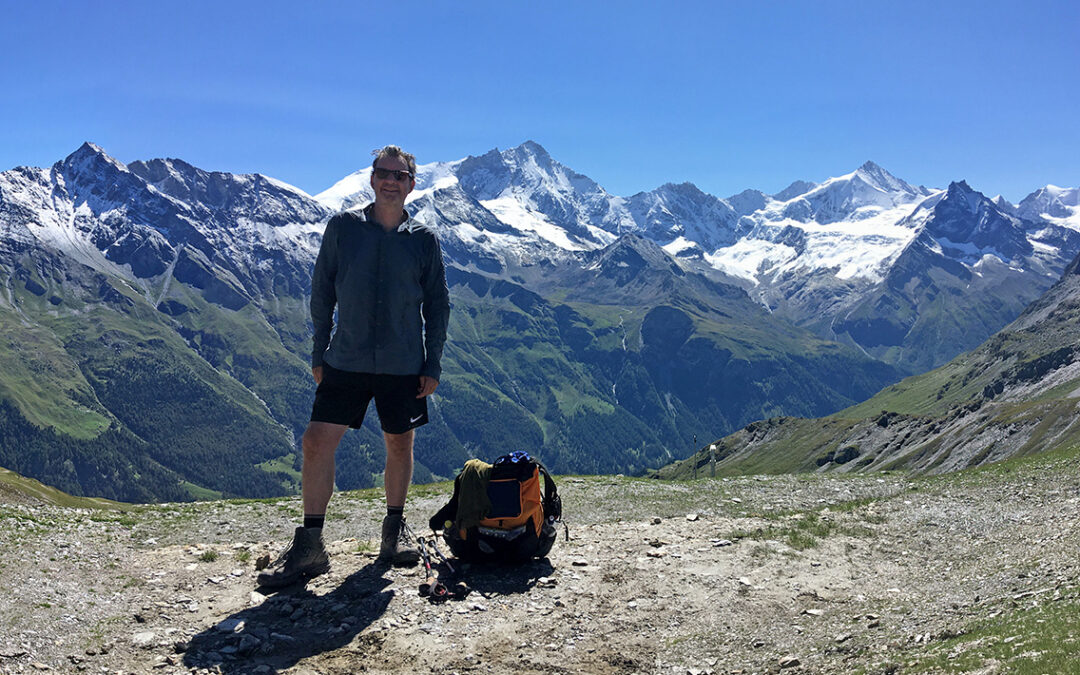
At 11.30 am I reached the Col de Sorebois. This col had one of the most amazing views of the entire Haute Route, with white peaks of the Bishorn, the Weisshorn and the Zinalrothorn, among others (see photo on top of this post). There were quite some people on the col, mostly coming from the east side of the saddle, where the cable cars had taken them from the deep valley.
Hiking down, the only shade I could find was a ski lift pylon below the col. So I sat there for a while, eating the rest of my lunch I bought at Cabane de Moiry (which at CHF 17 was more than a bit expensive, by the way).
The next half hour I was crossing a scarred skiing field with lots and lots of people strolling about, all swarming around an ugly and noisy cafetaria. This was really the least attractive part of the Haute Route. But hiking on swiftly, I was alone again soon, with a beautiful descent ahead of me.

Bishorn, Weisshorn (4.505 m / 14,780 ft), Schalihorn (center), the white Zinalrothorn and the black Besso (right)
Zinal
There are several trails leading to Zinal, but the direct route to the campsite La Tzoucdana, located south of the village, is the La Latte trail. Now officially this trail was closed and a detour north of the village was announced on paper signs. The yellow metal sign at one of the crossroads was covered with grey tape to indicate this closure. But I didn’t feel like hiking back to the crowded trails, so I followed the trail to La Latte anyway.

Descending La Latte
The trail was actually not physically closed, it was just closed because big trucks were hauling up massive parts for a new ski lift. So all it took was listening careful for upcoming trucks, and stepping aside when one passed me.

Zinal Valley with campground
Before I came to the last part of the trail zigzagging down, I could see the campground across the river. At that moment there were just a few tents in the grassy field, but the camping would fill up completely during the rest of the day.

The river La Navisence, next to the campsite of Zinal
At 2 pm I arrived at the camping La Tzoucdana rather overheated – the temperature down in the sunny valley was high and there was only little shade on the campground. So after I put up my tent (the first time this hike!) I cooled down in the nice river next to the campground.

The old village of Zinal
More than being a camping, La Tzoucdana is actually a restaurant in the first place, very popular with day tourists (hence the big parking lot). But despite of the crowds it was actually a nice place, with some good foods. The proprietors had created lots of shade with big parasols, and there were enough seats and tables for everyone.

My perfectly pitched Zpacks Duplex tent at La Tzoucdana
I spent most of the afternoon in the shade, writing notes, reading and retracing today’s route on my map. And I made a short walk to the village supermarket, for my regular grocery list of Swiss cheese, yoghurt and fruit.
It was very nice to be camping again. I had missed my little blue tent the past days in the mountain huts.
< Previous: Haute Route 5: Cabane de Moiry
> Next: Haute Route 7: Meidsee
Did you have to book a spot at the campground in Zinal or was it first come first served??
Hello Michelle, I did not book a place for the campground, I don’t think they take reservations at all. There is quite a large field that fills up with tents during the afternoon. I’m sure there will always be enough room for your tent.
Ok great! Thanks for the information. Your blog has been really helpful for me for planning some epic treks. I did the Escalante Route in the Grand Canyon this spring – following your route almost exactly. It was one of the best backpacking trips I’ve ever done!
That’s wonderful, thank you.