A long and spectacular day 7 of the Haute Route brought a view of Val d’Anniviers with the Bernese Alps in the distance. Then the first view of the Matterhorn peak and excellent wild camping at the Meidsee at the end of the day.
Haute Route 7: Zinal to Meidpass and Meidsee
Start: Zinal, 1.678 m (5,505 ft)
End: Meidsee, 2.664 m (8,740 ft)
Distance: 25,9 km (16.1 mi)
Elevation gain: 1.469 m (4,820 ft)
Elevation Loss: 483 m (1,585 ft)
Highest point: Meidpass, 2.832 m (9,291 ft)
Time: 8:15 hrs moving time; 11 hrs total time
Date: August 6, 2020

Haute Route day 7: Zinal to Meidpass and Meidsee (base map layer by Gaia GPS)
Zinal to Bella Lé
I Woke up at 5.30 am and I thought it would be smart to be first at the showers. There were just two showers for what must have been at least 50 hikers in the campground this night. Then I packed all my stuff except my tent, because it was completely wet with condensation (this is wat camping so close to the river means).
At 6 am I was eating a muesli breakfast with my Lapsang Souchong tea, still in the early morning twilight. A group of a dozen young climbers, just like me eager to get to higher elevations as early as possible, was having a big breakfast next to me.

Having finished my breakfast, my tent was still very wet. So I made sure all my gear was secure in my waterproof inline bag and I put the wet tent on top of it, inside my backpack. It was just before 7 am when I left the campsite. I walked to the village again, but now turned to a path to the east, away from the supermarket, passing some apartment buildings and then headed steeply up into the forest. Hotel Weisshorn was already announced in yellow paint on a big rock.

View of the Zinal valley with the dark top of Besso on the left, Pointe de Zinal (center) and Dent Blanche (4.357 m) just behind Grand Cornier and Pigne de la Lé on the left.
Once I reached an elevation of about 2.300 m (7,500 ft), a long stretch of balcony trail started. The trail going north along the east wall of Val d’Anniviers was easy going now, a relief after the short steep climb, with the sun already heating up the valley.

Drying my tent with a view of Col de Sorebois and its ski slopes
Now it was getting warm, it was time for a break and a first attempt to dry my tent. Eating a small snack and watching my tent glistering in the sun, I looked back at Col de Sorebois. I remembered yesterdays view from the col to where I was now – what a distance!

View from the Berneuse Alpage with the same group of mountains – but now with the snow top of the Matterhorn popping up from behind (little white cap right of the black Besso)
Hiking on, it was getting hotter and hotter, so after a while I took a break again at a point called Bella Lé (at 2.367 m), where I could cool my feet in an ice cold stream, and do a second phase of tent-drying.
I cooled my feet until it hurt, after which my feet felt 1 size smaller in my boots.
Hotel Weisshorn
This balcony trail is truly spectaculair, with views of the valley below and the Bernese Alps far away. Preparing this thru-hike, I had read that this part of the trail was one of the highlights in the Alps, and it certainly did not disappoint me.

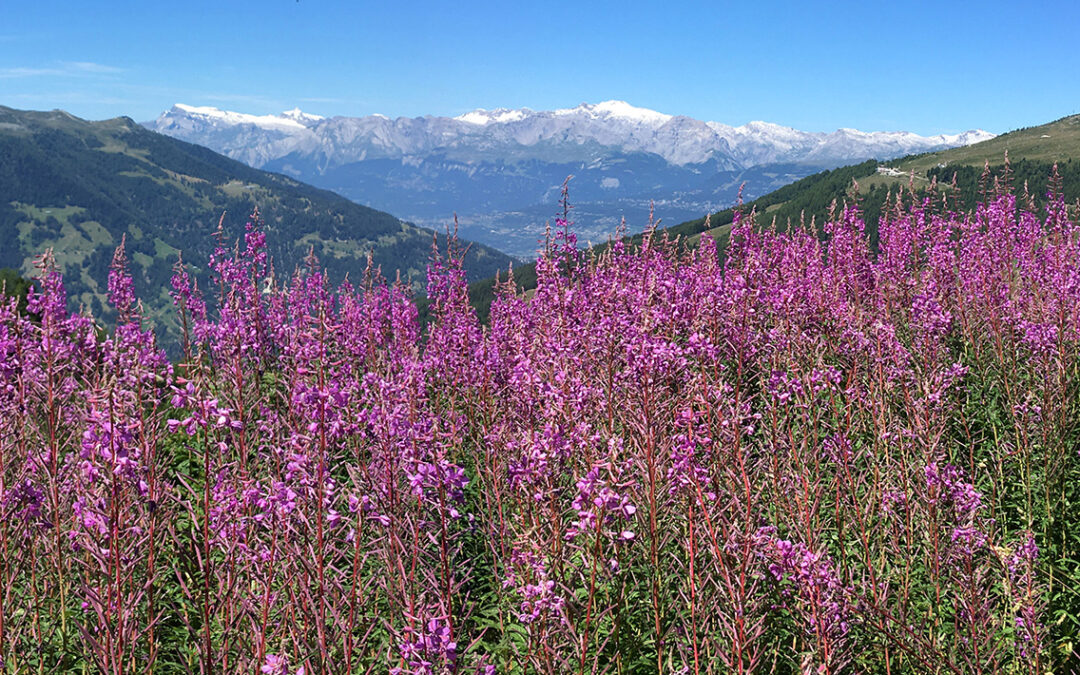
View of Val d’Anniviers and the Bernese Alps in the distance
Hiking on, the trail began to climb to higher elevations again, and then I saw Hotel Weisshorn in the distance. It did not take too long before I reached the hotel. At 11.30 am, and it was already crowded (there is a road and cable cars close by). All tables required a reservation, so even the empty tables were not free to use. But I found an abandoned deck chair at the back of the hotel, hauled it to a spot in the shadow with a view of the valleys, enjoying my Cola Zero and some snacks.

After phase 3 of drying my tent, it was finally good to pack, and I was ready to start the second part of the trail.

On the way to Le Chiesso
Cabane Bella Tola
There are different routes to the Meidpass, the first and shortest way is turning east at Le Chiesso for a direct approach. But this route misses the Bella Tola hut with a promise of outstanding views, so I decided to on north.

Approaching the Cabane Bella Tola
It took me 1:30 hours to reach the Cabane Bella Tola on the extended part of the balcony trail. The extra time and effort was well worth it: the crowds thinned out, the lovely trail was getting more and more quiet and the view even better.
Cabane Bella Tola was a very nice small mountain refuge with a wonderful terrace (with parasol for shadow), looking out over the valleys below. I was very glad the outside restaurant was still open, while the hut was closed for the night due to Covid. The most visitors here were apparently non-hikers, due to a cable car or something nearby.

View from Cabane Bella Tola: snow capped Weisshorn (4.505 m) on the left and Dent Blanche (4.357 m) just right off the center. In between the Matterhorn.
The views from the cabane were marvelous. Looking south I had the first glimpse of the Matterhorn, aided by the display, naming all peaks in the distance. Note: Matterhorn is called Mt. Cervin in French. (Unaware that the Matterhorn was already visible from the Berneuse Alpage a few hours before.
After a bowl of fried potatoes and a drink, I was allowed to use the bathroom inside of the hut. I got myself 2 liters of fresh, cold water and I hit the trail again for what was to be the most impressive part of the Haute Route.
Lac de la Bella Tola
Leaving the cabane, the trail was pretty straightforward, but after some time there were many trails and service roads crossing each other, or they were aligned side by side. So at one moment I lost the trail and deviated a bit. After some wayfinding, consulkting both my map and my GPS app, I found the right trail to the lake of Bella Tola.

Lac de la Bella Tola with the small stone cabin on the far side
It was late in the afternoon and despite the altitude it was quite hot. So when I finally reached the Lac de la Bella Tola, I jumped in for a hort swim in the ice cold water. Oh that is SO good.
Unfortunately I cut my toe while losing a flip flop that I was wearing for protection. Next time I will bring my water shoes instead.

Lac d’Armina, one hour before reaching the Meidpass
It was getting late and very quiet now, at 4 pm. I had the trail all to myself. I passed a beautiful lake just before the pass, with good wild camping possibilities. I had set my mind to camping at the Meidsee though, so I pushed on to the pass. But what a wonderful place this was.
Meidpass
Then followed a long and steep ascend. I was going slow, the air was thin, I was tired and the climb did not seem to have an end. But then suddenly: the Meidpass! It was 5:15 pm when I stepped on top of the pass, 2.5 hours from cabane Bella Tola.

The Meidpass with white cap of the Dom (4.546 m) on the left and the sharp top of Weisshorn (4.505 m) on the right.
What a view: snowy white mountain tops far beyond, and a big field of scree in front of me. Then a sound that startled me at first: a deep, echoing call. A slow two-note melody. Then I realised it was someone blowing an Alphorn! There was not a man to be seen anywhere – the sound of this horn must carry many miles through the valley. It felt like a welcoming concert, now I was entering the German speaking part of the Haute Route in the Turtmanntal.

View from the Meidpass with Meidsee in the distance. Distinctive Schwartzhorn (3.196 m) in the center, the white Fletschhorn (3.990 m) far behind it.
I really like being alone on the trail, but somehow the emptiness of the rocky field below me made me nervous for a moment. This would be my first wild camp in the Alps, and wasn’t sure what to expect at the lake.
Meidsee
I didn’t take long to reach the deep blue lake, now I was descending again, attracted to the lake like a magnet.

Reaching the Meidsee in about half an hour from the pass, I saw a lone hiker on the edge of a cliff at the lake (what a spot!) and in the distance a group of 3 or 4 hikers were just getting out of the water after a swim.
Unlike trails in the High Sierra and on the Tour du Mont Blanc, I found hikers in this part of the Alps more solitary, less eager to make contact with others. Maybe because there are more people on the trail, or because everybody is doing their own specific trail (apart from fellow Dutchman Keimpe I met on day two, I did not meet any other Haute Route hiker). So anyway, we all kept to ourselves and I set up my tent on a hill east of the lake.

Wild camping at the Meidsee with my Zpacks Duplex tent
I found a nice spot where others had built a small rock wall. It seemed a good idea to use this wall to protect against the strong wind blowing from the pass over the lake.
When my tent was pitched, I walked to the lake to wash myself with the ice cold water. I collected 2 liters of fresh water, that I filtered at my tent again. I was almost too exhausted to make myself a meal. But the dehydrated pasta did not take much effort to prepare. So after this delicious dinner and a cup of tea I went to sleep early. This was a long, demanding but unforgettable day.
< Previous: Haute Route 6: Zinal
> Next: Haute Route 8: Sankt Niklaus
0 Comments