On day 9 of the Haute route I hiked the valley bottom of the Mattertal to the village of Herbriggen, because the first half of Europaweg to Zermatt was closed. Then I climbed out of the valley again, up to the Europahütte, halfway the Europaweg trail.
Haute Route 9: Sankt Niklaus to the Europahütte
Start: Sankt Niklaus 1.110 m (3,642 ft)
End: Europahütte, 2.220 m (7,283 ft)
Distance: 14,3 km (8.9 mi)
Elevation gain: 1.494 m (4,902 ft)
Elevation Loss: 349 m (1,145 ft)
Highest point: Geisstriftbach river crossing, 2.601 m (8,533 ft)
Time: 5:45 hrs moving time; 6:50 hrs total time
Date: August 9, 2020

Haute Route day 9: Sankt Niklaus to the Europahütte – Note: North is on the left
The valley walk to Herbriggen
The friendly warden of the hotel La Réserve in Sankt Niklaus served an early breakfast especially for me at 6.30 a.m. so I could be on the trail to Herbriggen at 7 o’clock.
The last stretch of the Haute Route to Zermatt follows the Europaweg, a balcony trail high up the east side of the valley. Hiking through the valley is usually just the bad weather option.

The first part of the valley walk follows the river and the railroad south.
Unfortunately, the northern part of the Europaweg between Grächen and Galenberg is closed due to rock fall in 2019. And when I say ‘closed’, I really mean that the trail is physically closed. Huge parts of the trail have collapsed and trying to hike there would be deadly dangerous.
So in the past two hiking seasons, and probably a lot of seasons in the future, hikers have to use the valley trail to Herbriggen and ascend to the Europaweg from there.
2024 update: The original Europaweg between Gasenried and Galenberg is now permanently closed. A new trail has been built between these points. Make sure to use up-to-date information on this section, as all guidebooks and maps before 2023 might be unreliable.

A perfect camping spot on the trail to Herbriggen
The valley walk was almost completely flat and easy going. It made a good warming up exercise to start my day. Within an hour I approached the little village of Herbriggen. Temporary paper signs were taped to the yellow metal signposts to guide hikers from the alternative valley trail up to the Europaweg. Crossing the railroad and passing a small church in Herbriggen, I followed the very steep trail through the woods, all the way up to Galenberg.

The final part of the trail before Galenberg, with a camouflaged trailer against the rock wall.
The trail was very steep with loose rocks and tree roots making the ascend a bit tough. Although I was still in the shadow, it was getting hot with the humid air under the trees. After 1:30 hours of climbing I passed a water fountain, a good place to take a short break (although I still had plenty of water with me).
Further on, below a steep ridge, I found a camouflaged trailer (see photo above) resting against the rock wall. I couldn’t see what is was for.
Galenberg
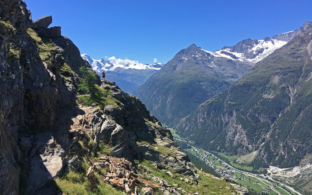
It took me three hours of climbing to get to the ‘top’ of the trail at Galenberg, a yellow-green meadow, now in the full sun – Galenberg is a mountain top nearby, but apparently the meadows below it go by the same name. At this altitude I felt a light breeze welcoming me, and what a view!

Weisshorn and Bisgletscher on the right – and Matterhorn peeping from behind
From Galenberg the trail was relatively flat, curving around the mountains, with sometimes a short climb. Every now and then there was a deep chasm next to the trail, which was very scary for people with vertigo like me.
The small stream called Birchbach is a moderate stream in summer. But according to the bridge and the broad dry riverbed it must be quite wild in other seasons. Crossing this wobbly bridge I thought with fear about the big suspension bridge which I would cross the next day.

Crossing the Birchbach on this wobbly metal bridge was today’s highlight of excitement.
I crossed another stream where I could wet my shirt and hat, trying to cool down as the midday sun was starting to heat up the day. It was a pleasant walk, and it took me about 2 hours from Galenberg to reach the Europhütte, which was invitingly perched on a rock and surrounded by trees.
Europahütte
It was only half past one p.m. when I arrived at the Europahütte. The wooden hut was quite small but had a terrace all around, shaded by a few parasols. At an elevation of 2.220 m. (7,283 ft) the Europahütte offers nice views across the narrow valley (but no view of the Matterhorn).

Europahütte, halfway the Europaweg trail
Compared to Cabane de Moiry, this is a small hut and it has a completely different atmosphere. A more traditional (though not very old) wooden building, it was more cosy with a fireplace (that we didn’t need today of course) and a big cupboard full of books and boardgames.
The rooms were quite small and cramped with bunkbeds, but I was lucky the six-person room was only booked half full. It was so narrow, I hardly found enough room to put my backpack next to my bed. Of course I took a refreshing shower first, before I sat down outside under a parasol with a homemade Apfeltorte.

Charles Kuonen suspension bridge
From the terrace I had a view of the infamous Charles Kuonen suspension bridge, spanning 494 m. (1,621 ft) and running 85 m. (279 ft) above the ground. It looked horrifying. I had read about the bridge, but had not realized that I probably would be scared to death crossing at it. It made me question myself: why do I love the mountains so much, while I am terrified by them at the same time?

The Europahütte at 2.220 m ü M (meter über Mer – above seal level)
The dinner in the Europahütte was a somewhat mediocre. My vegetarian meal was a thick slice of white bread soaked in cheese and egg. Although this was apparently a Swiss traditional meal, I would I really have liked some vegetables with it. I shared the dinner table with a group of young Swiss and Italian hikers, who did the partly overlapping Tour du Monte Rosa. In a mixture of Italian, German and English it became a noisy but amusing meal.
< Previous: Haute Route 8: Sankt Niklaus
> Next: Haute Route 10: Zermatt

0 Comments