Offering more than 100 hiking trails, Sedona is known as the Day Hike Capital of America. Many of the shorter trails can be combined to one long day hike, as I did on a sunny November day when I linked as many as 7 trails to reach Secret Canyon and Sterling Pass in one day.
Secret Canyon – Sterling Pass, Sedona
Location: Sedona, Arizona, USA
Trails: Chuckwagon, Dry Creek, Secret canyon, David Miller, Bear Sign, Vultee Arch, Sterling Pass
Distance: 13.4 miles (21,6 km)
Elevation gain: 2,405 ft (733 m)Elevation loss: 1,988 ft (606 m)
Highest point: Sterling Pass, 5,922 ft (1.805 m)
Time: 6:20 hrs walking time, 7:25 hrs total timeHiked: November 7, 2022
Getting to the Trailhead
I was staying at the Manzanita campground north of Sedona for a couple of nights, so I wanted to finish my hike at the Sterling Pass trailhead, just across the road from the campground. Hence I needed transport from Manzanita to the trailhead on the other side of Wilson Mountain, northwest of Sedona.
I have already written about the difficulties finding a taxi in Sedona for my Wilson Mountain hike. This time I tried Sedona Taxi. Well… at least he showed up (15 minutes late) and he drove me to the Longs Canyon Trailhead in a beaten up and rusty car (for $50).

Overview of all connecting trails from Longs Canyon Trailhead to Manzanita Campground
To get to the Secret Canyon trailhead there are three options. The first option is driving all the way on Dry Creek Road and park at the Secret Canyon trailhead. Beware that this road is extremely bumpy and can only be accessed by 4×4 wheel vehicles – and no taxi service will get you there.
If you don’t have a 4×4, you could choose the second option: park your car at the Dry Creek trailhead and walk the long and dusty Dry Creek Road to Brins Mesa and eventually to Secret Canyon Trailheads. This would take you about an hour and a half.
I decided on the third option, starting at Longs Canyon trailhead. From this trailhead I followed the Chuckwagon Trail to Brins Mesa trailhead and to the Secret Canyon Trailhead. Compared to the long Dry Creek Road, I think this is the most scenic option (and about 30 minutes shorter).
Chuckwagon Trail

Chuckwagon Trail
At the Longs Canyon trailhead there is a small parking lot with acces to Longs Canyon at the west side and to the Chuckwagon trail on the east side. It was 8.15 a.m. when I fastened my backpack and laced up my boots one more time and took off on the trail east. The Chuckwagon trail was meandering through trees and shrubs with red mesa’s in the distance. What a fine trail to start the day!
From the trail there was no sign of the city of Sedona nearby, it was as if I was hiking in a desolate wilderness. Halfway to the Brins Mesa trailhead I only saw one isolated desert villa in the distance and a NO TRESPASSING sign in the ground.
I crossed a small stream – which was actually Dry Creek – and climbed out of the woods to a more open area. I had reached the junction with Dry Creek road and the Brins Mesa trail.

The red dirt track of Dry Creek Road
Dry Creek Road
Dry Creek road is a wide jeep track of red earth, with ruts a foot deep. Even with a 4×4 vehicle this would be a hard day’s drive. Luckily I was early (it was 9 a.m. now) and there was not a soul – nor a 4×4 – around.
I walked the dirt road for about 15 minutes, until I reached the Secret Canyon Trailhead sign. This road walk was not as bad as I had I feared: not the hot, crowded and dusty nightmare I saw on a Youtube video. I was happy with my decision to hike Sedona in Autumn.

Sign on Dry Creek road to Secret Canyon
Secret Canyon Trail
I turned left from the dirt road onto a narrow and more shaded trail. The vegetation was a strange combination of fir trees, oak, cacti, agave plants and the typical red branches of the Manzanita shrubs. Then I hiked into a more open field with yellow grass, white plumes and large slabs of red rock. All the colors on this trail didn’t stop to surprise me.
Below me, on the left, I saw the dense woods of HS Canyon (the name presumably comes from the early settlers finding lots of horse shit here). Above this green canyon the huge red and black walls of unnamed mesas towered in the blue sky.

Secret Canon, hidden between red walls
Within an hour from the Brins Mesa junction, I arrived at the trailhead of the actual Secret Canyon. Following the small wooden sign I entered the canyon. First I climbed along a deep cleft in the red rock (and lost track for a moment), then I descended to the wooded bottom of the canyon, abundant with trees and cottonwood.

Secret Canyon in fall colors
The canyon was beautiful. It was colorful, silent and a bit mysterious because of the dense trees. The yellow color of the cottonwood trees contrasted magnificently with the red canyon wall. The entire canyon trail is about 5 miles in and 5 miles out (it’s a dead end), but I did not intend to hike the entire trail today. I had many miles to hike all the way to Sterling pass today, so I turned around after about 30 minutes. It was not as if there was a real secret treasure waiting for me at the end of the trail.

Hiking out of Secret Canyon towards the David Miller trail
David Miller Trail
At the junction of Secret Canyon and David Miller trail there was a secluded and shaded area with logs and rocks lying around, providing a perfect picnic spot (or maybe a camp spot).

David Miller trail junction
Until now the trail had been fairly level, with no remarkable ascends. The David Miller trail however led to a much steeper section towards a nameless saddle that leads to Bear Sign Canyon. It was getting hot now and I was trying see the saddle above me, but because of all the trees and shrubs, I only saw the high point just before reaching it.
Bear Sign Canyon
From the saddle the trail plummeted into Bear Sign Canyon. It was dark and much cooler on this side of the saddle. The first thing I saw was some bear scat, living up to the name of the canyon. Descending into the dark canyon I was calling HEY BEAR every now and then. Even though the bear scat was dry, I didn’t want to take the risk of running into the big mammal today.

Crossing a dry creek in Bear Sign Canyon
Bear Sign Canyon was beautiful with all the fall colors and, once at the bottom, very easy and slowly descending all the way. The trail crossed the dry creek several times for quite some time and after about an hour on this trail I met the first other hiker of the day, a girl who was heading in the opposite direction. Later on the trail I saw three little tents pitched on the on the red slabs on other side of the dry creek, which surprised me. Not only because camping here is prohibited, but it was still so early (about 1 p.m.) and what would you do in that place all day – without a water source?
I had been hiking for about 5 hours when I reached the end of this part of the trail, at Sterling Canyon and the Vultee Arch trailhead.
Vultee Arch Trail

Vultee Arch trailhead, below Wilson Mountain.
The Vultee Arch trail started at a flat and open space below the huge Wilson Mountain – it was just one day before that I was standing at the steep cliffs on the north side, looking down at the canyon that I was about to enter now.

The trail to the arch was mostly flat and easy going, and shady. More fall colors here: flaming red leaves backed by orange, yellow and geen. Sedona is a great place to visit in November!

Vultee Arch
After an hour I reached the Vultee Arch side trail. From under the canopy of the tall trees I could see the arch reaching from left to right along the canyon wall. The side trail is only half a mile out and back, but I was getting tired after 6 hours of hiking and I especially didn’t feel like leaving the cool shadows to see the arch up close. I decided that this view alone was spectacular enough and I continued towards Sterling Pass.
Sterling Pass
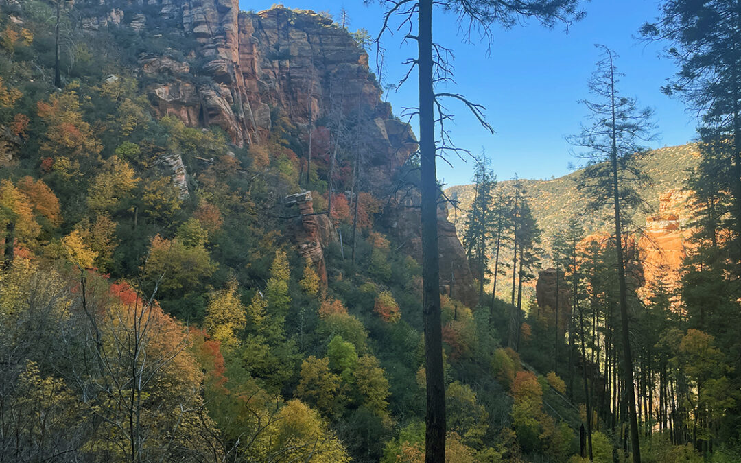
Following a steeper ascending path now, the canyon walls were closing in slowly. The autumn colors were unbelievable, contrasting with the black bark of the tall trees. I think this was the most beautiful of all of todays trails.

Sterling Canyon
The last 20 minutes to Sterling Pass were physically gruesome, though. To make the steep ascend bearable I started counting switchbacks – I lost count somewhere after 2o. But finally I reached the pass – an overgrown saddle with just enough room to sit down for a while. I drank most of the water that I had left, mixed with electrolyte lemonade powder.
Below me was the Sterling descent: yesterday I talked with two hikers about what difficulties I could expect on the Grand Canyon’s Tanner trail, a trail that I would hike four days later. They said if I could descend Sterling, I would be able to do Tanner just as well.

Looking back at Sterling Pass
The first switchbacks down from the pass were extremely steep, indeed. I had to go very slow and carefully manoever through the many branches and shrubs that almost blocked the trail. But it wasn’t really dangerous so when I reached the last switchback I felt more assured that my upcoming Grand Canyon hike would go just as well.
The last part of the trail were quite easy and within 30 minutes I could already see the yellow stripes of the US 179 below me. On the other side of the road I returned to Manzanita Campground.
Manzanita Campground

My Zpacks tent in the moonlight at Manzanita Campround
Back at Manzanita Campground I sat down at the banks of Oak Creek just a few steps away from my tent. Cooling my feet in the ice cold water I enjoyed the last rays of sun. When it got dark I made a fire and warmed myself until I completely burned two bags of firewood ($7 a piece) and it was time to go to sleep. In Oak Creek Canyon it first got very dark in the beginning of the night, but then the full moon would rise above the canyon wall. The moonlight was so bright, as if some Hollywood producer had forgotten to shut down the movie set light.