At day 4 of the Escalante Route I said goodbye to the Colorado River as I ascended to the Tonto Platform and beyond to the Hance Creek oasis.
Escalante Route Day 4: Hance Rapids to Hance Creek
Start: Escalante Beach (2,560 ft / 780 m)
End: Hance Creek (3,570 ft / 1.088 m)
Trail: Tonto East Trail
Distance: 6 miles (9,8 km)
Elevation gain: 1,375 ft (419 m)
Elevation loss: 420 ft (128 m)
Time: 3:35 hrs moving time; 4:10 hrs total time
Date: November 14, 2023

Escalante Route day 4: Hance Rapids to Hance Creek
Tonto Trail East
With probably the easiest section of my hike ahead of me, there was no need to hurry this morning. I slept over until 6.30 a.m.! It had been a cold night, but with 5 layers of clothing, a liner bag and my down quilt I made it through the night. After my oatmeal breakfast I tried to clean my tent, but it was even more dirty with wet sand than yesterday.
As I was wiping my tent floor in the dry creek bed, the 4 ladies from Escalante Beach passed by. They were heading back to the South Rim in one day on the New Hance Trail. I said that I was glad to have another 2 days in the canyon left.

The Easternmost point of the Tonto Trail
The first thing I did when I was all packed, was searching the East Tonto trailhead. There was no sign (as had been are none the entire hike) so I consulted my GPS app to find the trail somewhere behind the sand dune, close to the river.
The trail was sandy and flat but quite soon it turned left to higher elevation above the river. On my right hand I did see another parallel trail on the beach, but I am not sure if this trail ever connected with the Tonto trail.
I was moving further away from the Colorado River with every step now and I already began to miss its constant roar.
Mineral Canyon
The 500 ft (150 m) ascend to the entrance of Mineral Canyon took me about 30 minutes. Mineral Canyon look very dark and gloomy in the shadows of the early morning.

Looking down into Mineral Canyon
The trail was contouring all around this side canyon until the point where crossing was possible, just like before at 75 Mile and Escalante Canyon. First I entered a relatively flat part of the trail with giant boulders. The trail meandered through this field for a while and then continued ascending close to the canyon’s edge.

Mineral Canyon, backed by Coronado Butte (center left) and Ayer Point on the right
As I came closer and closer to the canyon crossing, the terrain changed from dark brown to grey and green and then to the deep red again. I crossed the (dry) Mineral Creek and ascended steeply through red sandstone until I arrived at the Tonto Platform.

Crossing Mineral Canyon, view of Cape Royal (North Rim) in center and the sharp Vishnu Temple on the right.
The Tonto Platform
The Tonto Platform is relatively flat area (hence ‘Platform’) with a distinctive grey-brown soil and silver-green shrubs of Mormon Tea and Blackbrush. It’s a dry desert with no shade and it gave me a somewhat desolate feeling. The trail was meandering under the watchful eye of Ayers Point (the top of a massive red and yellow wall). I passed a field with brown boulders and I had to keep a sharp eye out for cairns to be sure stay on trail.

The Tonto Platform
Hance Canyon
When I finally reached Hance Canyon, I was slightly shocked by the fathomless depth of the brown ravine in front of me. The Canyon was dark and deep and the trail so close to the edge. For the first time in 4 days I suffered from fear of heights. The difference with the previous exposed trails at Tanner or the Unkar Overlook was that now there was a slope to my left going up and a ravine to my right going down. And in between a narrow and rocky path. Falling here means a certain death.

Hance Canyon with a view of the giant Horseshoe Mesa
Luckily this intimidating part of the trail did not last long. The trail turned away from the canyon’s edge, contouring a more shallow wash on the left. After some more scrambling, cairn searching and persistently hiking on, I eventually saw the yellow and green leaves of the cottonwood trees in the distance below. A silvery stream of water was glinstering in the sun. I had almost reached the little oasis of Hance Creek.
Hance Creek

Cottonwood trees at Hance Creek and spring
After 4 hours of hiking completely alone, I felt delighted to see some form of human presence in the canyon. From above I saw rocks stacked under a big cottonwood tree, indicating a camp spot down in the canyon. I had to hike for another 1o minutes to reach the access to the canyon floor, right at the Hance Creek spring. An amazing sight: out of the dry creek bed full of pebbles and gravel there was a tiny stream of clear water emerging from the ground. Seemingly out of nowhere, a water source. Fresh, cold and clear.

Hance Canyon creek
I immediately filled my bucket with the fresh water, directly from the source. The water was quite different from the Colorado River: no silt, completely clear.
The actual campsites were a bit further downstream, soI walked towards the cottonwoods. Further down into the canyon the tiny stream grew into a more serious little creek, the one I had seen from above. I is possible to follow the creek all the way down to the canyon (for experienced canyon hikers only) to what is called Sockdolagers Rapids. If I ever come back here, I would certainly want to try that trail, as I love hiking in or close to creeks.

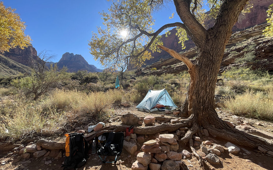
Hance Creek camp site
It was about half an hour past noon when I found the best camping spot right under the big tree with the stacked rocks. I sat comfortably in my camp chair in an excellent spot in the warm sun. A splendid oasis to enjoy my tuna tortilla. I took my time to filter water, journal and read for a while. This was my last afternoon in the canyon, tomorrow I would be back in the world, so I thought I might as well finish off my last chocolate and salty nuts now!
Before I knew, the sun was disappearing behind the red wall (at 2:30 p.m). Within minutes it was ice cold. I put on all my clothing, hat, gloves and decided to go for a short walk around my camp to keep warm.

Cottonwood trees at Hance Creek
As I was walking around I became aware I had not met a single hiker today and I did not expect to see anyone at this hour anymore. I was completely alone and I sensed the wild and sometimes dangerous environment of the canyon. But I felt safe, I felt at home. And I knew that I would miss this canyon terribly once I would emerge from the South Rim tomorrow.
< Previous: Day 3 – Escalante Beach to Hance Rapids
> Next: Day 5 – Hance Creek to Grandview Point
What was your starting pack weight Peiter?
My base weight was about 9 kilograms (19.8 pounds), this was including a 930 grams (2 pound) bear canister to keep my food safe from rats and birds.
If you have a rat sack you can save weight!
Plus 6 kg (13 pounds) of food and water (including 3.5 liter of water)
You can read the details on https://www.overseashiker.com/escalante-route-gear-list/.