An amazing third day on the Haute Route. I climbed four mountain passes, sled down a snowfield and crossed glacial waters. On the way there were turquoise lakes, a herd of ibex and I reached the highest elevation of the entire Haute Route.
Haute Route 3: Cab. du Mont Fort to Lac des Dix
Start: Cabane du Mont Fort, 2.451 m (8,041 ft)
End: Refuge des Ecoulaies, 2.568 m (8,425 ft)
Distance: 15,2 km (9,4 mi)
Elevation gain: 1.097 m (3,599 ft)
Elevation Loss: 969 m (3,179 ft)
Highest point: Col de Prafleuri, 2.987 m (9,800 ft)
Time: 6:50 hrs moving time; 9:10 hrs total time
Date: August 2, 2020

Haute Route day 3: Cabane de Mont Fort to Lac de Dix, base map layer by Gaia GPS
Col de la Chaux
The third day on the Haute Route started with a simple but good breakfast with muesli and a piece of bread. It was 6 a.m. and I was discussing today’s route with my fellow hiker Keimpe. Although the sky was partly clear and the heavy rain was over, the hut warden said the Col Termin route (also known as Sentier des Chamois), would still be too dangerous, being soaked with last night’s rain. So we decided to stick to yesterdays plan and hike the alternative route via Col de la Chaux.
At 6.45 a.m. we took the last pictures of the sun rising above the mountains, and up we went.

The Massif Mont Blanc in sunrise, view from Cabane du Mont Fort

Col de la Chaux in the distance seen from the hut
The trail up to Col de la Chaux was quite easy at first, a very broad track of ski piste, intersected by a ski lift to the Col des Gentianes. Then when the broad track swerved to the left, a blue arrow pointed to a more narrow trail up.

We passed a small tarn and then entered big snow field. The path actually ended and we needed to improvise our trail from here.From this point on, it became clear that the Haute Route was going to be something completely different from the Tour du Mont Blanc. The snow was hard and slippery and I really needed my hiking poles and all my strength to get to the top. I was very happy that I was wearing my good old sturdy hiking boots!

Hiking together with Keimpe was fun and encouraging, now the trail got a bit rough. Keimpe put on his microspikes, a piece of gear that I had very much liked to have had for this col.
The clouds and constant threat of rain made us hike on in a steady pace, up to the first of the four cols of today.

Col de la Chaux at 2.945 m (9,662 ft)
Reaching the top of Col de la Chaux, we found a barren but beautiful landscape on the other side. Just black rock and snow – absolutely silent, not a sound to be heard.
The terrain was very rocky and the trail virtually non-existent. The only way to find our way was keeping a sharp eye on the blue-white blazes painted on the black stones.

Lac du Petit Mont Fort between Col de la Chaux and Col Louvie
After crossing the rocky basin, we hiked down a bit and passed a beautiful turquoise lake: lac du Petit Mont Fort. Then we sharply turned left, where our trail joined the end of the Sentier des Chamoix. A wonderful view of Lac Louvie below and the Grand Combin in the distance.

Looking back on the trail heading up to Col Louvie with Le Grand Combin in the background
From this point, the trail went up steeply to high and rocky terrain, leaving the short stretch of green and grassy trail behind us. Soon the next col came into view. The sky was still quite blue, so we climbed up higher without fear of thunderstorms.
Col Louvie
Col Louvie (2.922 m / 9,587 ft) was white with snow. Here we met the first of only a few hikers that day, going in opposite directions.
The eastern side of the col was packed with snow. Very carefully I tried to walk down through the snow, but at one moment I just slipped and continued the descent sliding on my butt. This would have been great fun, if not for the black rocks down below, where I was going to crash into very soon. Luckily, the slope was gradually getting gentler, so I hit the rocks with my boots without too much force.

Coming down from Col Louvie
Brushing off the snow off my pack and clothes, I had the first panoramic view of Le Grand Désert: a black rocky mess of stones, ice and more impressive turquoise tarns. The heavy clouds developing behind the rugged mountains were a reminder for us to keep on going.

Le Grand Désert
Entering the big black fields of Le Grand Désert, I was so much impressed by the emptiness of it. All that water and ice everywhere. Apart from the pink algae that live on the snow (Chlamydomonas nivalis), it seemed that no life could exist in this desert. No plants to as far as I could see, and no animals that I could imagine living here (I was proven wrong twice within half an hour).
We crossed the stream coming from the glacier, and continued over a relatively flat terrain, towards a big rock with a giant (at least 2 meters high) white-red-white blaze painted on it. In more snowy conditions this big blaze is the only indication to direct you across the field. With no snow in most places now, various other blazes were visible, and wayfinding was easy here. To my surprise i saw little cottonlike pink flowers close to the ground, growing from in between the rocks.

A herd of Ibex between Col Louvie and Col de Prafleuri
The trail was going up now, to what I believed to be Col de Prafleuri already. But this was just a short climb up, on a small hill between mountain passes, the type of ascent I would be calling a ‘false col’ from now on. My disappointment would be gone very soon though, because here we saw seven magnificent ibex! So I was wrong about no life being possible on these rocks. I still wonder what these animals eat here. The couple of flowers here couldn’t be enough to feed a herd?

Climbing down from the aforementioned false col, another field of glacial waters was revealed, with a black mountain pass (Prafleuri) far in the distance. The climb down was very difficult and it was certainly the most scary part of today’s trail. The trail had actually ended, and we found ourselves hiking along the steep slope though the snow. At one moment we had to step to another ridge of snow to make a corner. The snow ridge was so thin here, I couldn’t believe it would hold us – we looked right trough the snow into a deep hole. But we moved as slowly and careful as we could, and managed to get down safely.
Now we started crossing the final part of this black desert, past three extraordinary colored lakes and up we went to the third col of the day.
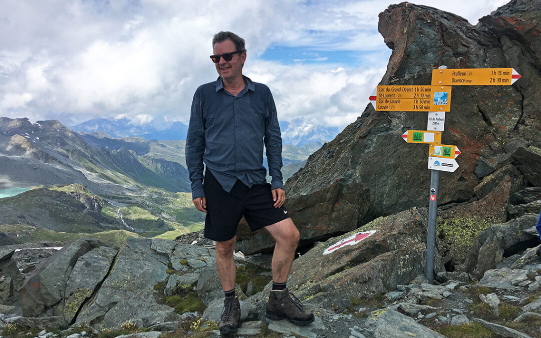
Col de Prafleuri
Finally: the climb up to Col de Prafleuri, at 2.987 m (9,800 ft) the highest point of the entire Haute Route (of all the mountain passes I have been in the Alps, they all seem te be just below 3.000 m, by the way). With one of the most amazing views I ever had, this was probably the highlight of the trail.

In the meantime my shoes had gotten a bit wet on the inside, and this worried me a great deal, for it was not even raining and I had another 10 days of hiking to do.

On top of Col de Prafleuri 2.987 m (9,800 ft)
Although we had been hiking for about six hours straight, we hardly had a rest and didn’t eat very much. I had no more than a piece of bread, some M&M’s and dried apricots. On top of the pass we had a break and I ate the rest of the bread and cheese that I still carried from the first day at Le Châble.
I took off my boots, trying to let the inside and my sock dry, which did not really work in the cold air, without sun.

Going down Col de Prafleuri I searched the horizon for the next mountain pass or hut, but nothing ahead hinted at any civilzation close by.

Again we crossed glacial waters, this time a bit more of a grey color, from the Glacier de Prafleuri. Not exactly a dangerous torrent, but a part of the trail that requires some concentration nevertheless.
Cabane de Prafleuri is located in a former rock quarry, where rocks were used to build the giant Grande Dixence Dam just around the corner of the mountain. At 285 m (935 ft) high, it is the tallest dam in Europe. From the trail the dam was not visible though, we would get a glimpse of it later. There was a small group of Chamois grazing on the first green patch of mountain since the grassy hill before Col Louvie. But beside these little animals, this part of the trail was not very attractive, not to say rather gloomy.

It was 2:30 p.m. when we reached the river just down below the hut. We had been hiking almost 8 hours and we were completely out of water by now. Not sure wether the hut was actually open (I had read online they would be closed until the next day) and not sure if we would find a source up the last hill, we filled our bottles with the water from the roaring river.
When we finally reached the top of a last steep rock, we saw the hut was actually open an we immediately headed for the bar to buy an ice cold Coke Zero and sat down for a while. From where we sat, we had an excellent view of the sharp zigzagging path to the last pass of the day: Col des Roux.
Before heading up, we saw a water fountain next to the hut and we both filled our bottles with 2,5 liters of clean water – after discarding the water we just took from the river. Probably it was exactly the same water, but somehow water coming from a metal tube feels more reliable.
Note to future hikers of the Haute Route: this is the first and only water source since Cabane du Mont Fort. Of course you could use water from the glacial streams and tarns, but that water appeared to be full of very fine grains of sand, ruining your water filter and maybe your stomach.
Col des Roux and Lac des Dix
We were ready for the last stretch of the day: Col des Roux. This was an easy climb, compared to what we had done before and within 20 minutes or so we made it to the top.

Col des Roux at 2.804 m (9,200 ft)
The view from this pass was amazing, with the giant Lac des Dix below and more snowy mountain tops in the background. Still not a drop of rain had fallen today and with the sky now filling up with clouds completely, we did not want to stay too long here. So down we went again, for the last time this day.
It took us just over half an hour to finally reach the Refuge des Ecoulaies. This is an unmanned hut in the meadows just above Lac des Dix. The hut is privately owned, and can be reserved in advance. For this day a reservation would not have been necessary: when we got there, we were the only guests. The only other hiker I saw was apparently hiking further down to the next (unmanned) hut, La Barma, fifteen minutes down the trail.
The hut had bunkbeds, clean water, tables and chairs, electricity and a flush toilet. Apart from a hot shower everything a weary hiker needs! We payed our CHF 20 by slipping a bill into a slot in a backdoor.

The unmanned hut Refuge des Ecoulaies
We cooked our meal outside until finally the long expected rain fell. We hurried inside where we spent the rest of the evening finishing our food and trying to find the switch for the lights.
Later we saw a marmot searching for crumbs of food from the stone fireplace where we sat. The evening fell, and it had been a beautiful and rewarding day.
Note for hikers looking for wild camping on the Haute Route. Between Cabane de Mont Fort and this hut, camping is virtually impossible. It is too high, too cold, too snowy and too rocky. On a few places at Lac des Dix wild camping is physically possible. Though signs point out that camping is strictly forbidden, I have seen and heard of hikers camping at the lake. But with two unmanned huts available, I thought it wiser and easier not to ignore the ‘No Camping’ sign here.
< Previous: Haute Route 2: Cabane du Mont Fort
> Next: Haute Route 4: Les Haudères
Hi there
What time of the year did you do this tour?
Looks amazing that tour…
Best Philipp
Hello Phillip,
I hiked the Haute Route in summer (August). The trail can be hiked from mid-July to September. Outside that period the mpuntain passes will be full of snow and hiking is not possible. Also the huts will be closed.
It is an amazing tour indeed, highly recommended (less crowded than Tour du Mont Blanc).